Vágar
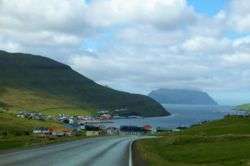
Vágar (Danish: Vågø) is one of the 18 islands in the archipelago of the Faroe Islands and the most westerly of the large islands. With a size of 178 square kilometres (69 square miles), it ranks number three, behind Streymoy and Eysturoy. Vágar region also comprises the island of Mykines.
Vágar Vågø | |
|---|---|
 Location within the Faroe Islands | |
| Coordinates: 62°05′N 7°16′W | |
| State | Kingdom of Denmark |
| Constituent country | Faroe Islands |
| Region | Vágar |
| Area | |
| • Total | 176 km2 (68 sq mi) |
| Area rank | 3 |
| Highest elevation | 722 m (2,369 ft) |
| Population (01-2020) | |
| • Total | 3.367[1] |
| Time zone | UTC+0 (GMT) |
| • Summer (DST) | UTC+1 (EST) |
| Calling code | 298 |
The Vágar island shape is very distinctive, since on maps it resembles a dog's head. The fjord Sørvágsfjørður is the mouth and the lake Fjallavatn is the eye.
History
Vágar is the first port of call for most foreigners travelling to the Faroe Islands, as it is home to the islands’ only airport, Vágar Airport. An airfield was built there during World War II by the British, who occupied the Faroe Islands with the islanders' consent. After the war it lay unused for about 20 years, but was then put back into service and expanded/modernised as required. It handles about 290,000 passengers a year (2016). Such large numbers by Faroese standards put a considerable strain on transport facilities, with the result that a road tunnel (Vágatunnilin) measuring 5 km (3 mi) in length and running under the sea now connects Vágar with the two largest islands in the Faroes and thus the capital Tórshavn.
Tourism
The tourist attractions on Vágar are excellent and perhaps the best in the Faroe Islands. The country's two largest lakes - Sørvágsvatn and Fjallavatn - are to be found there, and the tourist association organises excursions throughout the summer.
Villages
Vágar has three large villages: Miðvágur, Sandavágur and Sørvágur and three small ones: Gásadalur, Bøur and Vatnsoyrar. Earlier there were two more villages: Slættanes, which was abandoned in 1965[2] and Víkar,[3] which was abandoned in 1910.[4]
The largest is Miðvágur, which has 1,130 inhabitants[1] (01-2020). It is in the middle of the island and so has naturally become a centre, with a doctor's surgery, co-op and vicarage. It is also a historic village and was home to Beinta Broberg, a clergyman's wife who was dubbed “Wicked Beinta”. The story of her life was told in the famous novel Barbara by Jørgen-Frantz Jacobsen, which was filmed in 1997 by Niels Malmros. The farmhouse Kálvalíð to the north is the oldest house in the village and possibly in the Faroe Islands too. It is now the village museum.
To the east of Miðvágur lies Sandavágur, which has a population of 958 (01-2020). It too is a historic village. It was home to the law speaker of the Faroe Islands until 1816, when the office was abolished and the islands became a Danish administrative district. The clergyman V. U. Hammershaimb, who was born in Sandavágur in 1819 and became the father of the Faroese written language, was the son of the last law speaker. The Sandavágur stone with a runic inscription dating back to around 1200 was found there in 1917 and can now be seen in the Sandavágur church.
The third large village is Sørvágur, which is on the western side of the island near the airport and has 1,136 inhabitants (01-2020). During World War II, when the airfield was being built in 1942–1944, 5,000 British soldiers lived in Sørvágur, but now few traces remain of their camp to the south of the village. Tindhólmur, Gáshólmur and the two “drangar” (freestanding cliffs) belong to the village. The view out to them is among the most beautiful in the Faroe Islands.
Vágar has two other old villages: Bøur, which lies 4 kilometres (2 miles) west of Sørvágur and has 74 inhabitants (01-2020), and Gásadalur, which lies further west on Mykines Fjord and has just 16 inhabitants (01-2020). Many people have moved away from this village, but it now has a road link in the form of a tunnel through the mountain and it is hoped that the village will start to grow again.
A new village, Vatnsoyrar, which has 44 inhabitants (01-2020), appeared on Vágar in 1921. It was founded by three men, each of whom was given a plot of land to farm and set up home there with his family. The village is in the upland pastures belonging to Miðvágur and so forms part of Miðvágur District. When the British occupied the Faroe Islands and built the airfield on Vágar, Vatnsoyrar was their headquarters. The local population was evacuated, but was able to return home when the war ended.
At the northernmost point of the island, in the upland pastures belonging to Sandavágur, lay the village of Slættanes, which was founded in 1835. It grew for a time and at its largest was home to around 70 people. It also had a school, which can be seen on a stamp. The last residents left in 1964.
Another new village, Víkar, was founded in the upland pastures belonging to Gásadalur on the north side of the island in 1833. The area was good for farming, but the settlement was very isolated, and getting to the next village was a difficult business. The last few inhabitants moved away in 1910.
Geography
Climate
| Climate data for Vágar Airport, Vágar, 84 m.a.s.l. | |||||||||||||
|---|---|---|---|---|---|---|---|---|---|---|---|---|---|
| Month | Jan | Feb | Mar | Apr | May | Jun | Jul | Aug | Sep | Oct | Nov | Dec | Year |
| Record high °C (°F) | 10.3 (50.5) |
9.5 (49.1) |
12.5 (54.5) |
14.8 (58.6) |
20.8 (69.4) |
21.6 (70.9) |
24.0 (75.2) |
23.5 (74.3) |
20.5 (68.9) |
14.0 (57.2) |
12.0 (53.6) |
12.2 (54.0) |
24.0 (75.2) |
| Average high °C (°F) | 4.8 (40.6) |
4.8 (40.6) |
5.2 (41.4) |
6.4 (43.5) |
8.8 (47.8) |
10.8 (51.4) |
12.1 (53.8) |
12.3 (54.1) |
10.4 (50.7) |
8.6 (47.5) |
6.1 (43.0) |
5.3 (41.5) |
8.0 (46.4) |
| Daily mean °C (°F) | 2.7 (36.9) |
2.7 (36.9) |
3.1 (37.6) |
4.3 (39.7) |
6.6 (43.9) |
8.7 (47.7) |
10.2 (50.4) |
10.4 (50.7) |
8.6 (47.5) |
6.8 (44.2) |
4.2 (39.6) |
3.3 (37.9) |
6.0 (42.8) |
| Average low °C (°F) | 0.5 (32.9) |
0.6 (33.1) |
0.9 (33.6) |
2.1 (35.8) |
4.4 (39.9) |
6.6 (43.9) |
8.3 (46.9) |
8.5 (47.3) |
6.7 (44.1) |
4.8 (40.6) |
2.1 (35.8) |
1.1 (34.0) |
3.9 (39.0) |
| Record low °C (°F) | −10.0 (14.0) |
−11.7 (10.9) |
−10.6 (12.9) |
−9.9 (14.2) |
−5.0 (23.0) |
−0.3 (31.5) |
1.4 (34.5) |
1.0 (33.8) |
−2.5 (27.5) |
−6.4 (20.5) |
−10.0 (14.0) |
−10.9 (12.4) |
−11.7 (10.9) |
| Average precipitation mm (inches) | 163 (6.4) |
122 (4.8) |
141 (5.6) |
120 (4.7) |
83 (3.3) |
81 (3.2) |
115 (4.5) |
133 (5.2) |
151 (5.9) |
164 (6.5) |
140 (5.5) |
142 (5.6) |
1,555 (61.2) |
| Average precipitation days (≥ 1.0 mm) | 23 | 19 | 21 | 18 | 13 | 11 | 15 | 18 | 19 | 20 | 18 | 20 | 215 |
| Source: Danish Meteorological Institute[5] | |||||||||||||
Important Bird Area
The north-west, west and south-west coasts of the island have been identified as an Important Bird Area by BirdLife International because of their significance as breeding sites for seabirds, especially northern fulmars (100,000 pairs), European storm petrels (5000 pairs), European shags (500 pairs), great skuas (20 pairs), black-legged kittiwakes (8400 pairs), Atlantic puffins (40,000 pairs), common guillemots (2700 individuals) and black guillemots (400 pairs).[6]
Mountains
There are 41 mountains on Vágar, the major ones are:
| Name | Height |
|---|---|
| Árnafjall | 722 m[7] |
| Eysturtindur | 715 m |
| Malinstindur | 683 |
Major lakes
| Name | Area |
|---|---|
| Sørvágsvatn | 3.4 km2 |
| Fjallavatn | 1.02 km2 |
| Vatnsdalsvatn | |
| Kvilkinnavatn |
Major waterfalls
- Bøsdalafossur
- Múlafossur
- Reipsáfossur
Islets and rocks in the sea
- Tindhólmur
- Gáshólmur
- Skerhólmur
- Trøllkonufingur
- Dunnusdrangar
- Filpusardrangur
- Drangarnir - Lítli Drangur, Stóri Drangur
References
- Statistical Database
- "Visitvagar.fo, Slættanes". Archived from the original on 2014-03-02. Retrieved 2013-10-07.
- "Visitvagar.fo, Víkar". Archived from the original on 2015-06-12. Retrieved 2015-06-12.
- Heimabeiti
- "The Climate of The Faroe Islands - with Climatological Standard Normals, 1961-1990 Greenland" (PDF). Danish Meteorological Institute. Retrieved August 19, 2015.
- BirdLife International. (2012). Important Bird Areas factsheet: Vágar. Downloaded from http://www.birdlife.org on 2012-02-24.
- "US.fo, Fjøll". Archived from the original on 2015-07-15. Retrieved 2015-07-15.
External links
- Stamps.fo (public domain by Postverk Føroya)
- Personal website with 78 aerial photos of Vágar
| Wikimedia Commons has media related to Vágar. |


