Vadlamudi
Vadlamudi is a village in Guntur district of the Indian state of Andhra Pradesh. It is the headquarters of Chebrolu mandal in Tenali revenue division. It is located in Chebrolu mandal of Tenali revenue division.[2]
Vadlamudi | |
|---|---|
Village | |
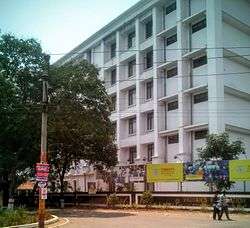 Vignan University building, Vadlamudi | |
.svg.png) Vadlamudi Location in Andhra Pradesh, India | |
| Coordinates: 16.2356°N 80.5605°E | |
| Country | India |
| State | Andhra Pradesh |
| District | Guntur |
| Mandal | Chebrolu |
| Government | |
| • Type | Panchayati raj |
| • Body | Vadlamudi gram panchayat |
| Area | |
| • Total | 1,518 ha (3,751 acres) |
| Population (2011)[3] | |
| • Total | 9,346 |
| • Density | 620/km2 (1,600/sq mi) |
| Languages | |
| • Official | Telugu |
| Time zone | UTC+5:30 (IST) |
| PIN | 522212 |
| Area code(s) | +91–8644 |
| Vehicle registration | AP |
Geography
Vadlamudi is situated to the northeast of the mandal headquarters, Chebrolu,[4] at 16.2356°N 80.5605°E. It is spread over an area of 1,518 ha (3,750 acres).[2]
Governance
Vadlamudi gram panchayat is the local self-government of the village.[1] It is divided into wards and each ward is represented by a ward member.[5] The village forms a part of Andhra Pradesh Capital Region and is under the jurisdiction of APCRDA.[6]
Economy
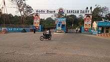
Sangam Dairy is the cooperative dairy for processing milk, which was formed by the Guntur district milk producers union.[7]
Transport
Tenali–Narakodur road passes through Vadlamudi.[8] Rural roads connects the village with Chebrole, Penugudurupadu and Sreerangapuram.[9] On this route, APSRTC operates buses from Guntur and Tenali bus stations.
Education
As per the school information report for the academic year 2018–19, the village has a total of 7 schools. These schools include 3 Mandal Parishad and 4 private schools.[10]
See also
References
- "Gram Panchayat Identification Codes" (PDF). Saakshar Bharat Mission. National Informatics Centre. p. 99. Archived from the original (PDF) on 18 August 2017. Retrieved 9 May 2019.
- "District Census Hand Book : Guntur (Part B)" (PDF). Census of India. Directorate of Census Operations, Andhra Pradesh. 2011. pp. 14, 414. Retrieved 2 June 2019.
- "Population". Census of India. Registrar General and Census Commissioner of India. Retrieved 9 May 2019.
- "District Census Handbook : Guntur (Part A)" (PDF). Census of India. Directorate of Census Operations, Andhra Pradesh. 2011. pp. 5, 662–663. Retrieved 4 June 2019.
- Seetharam, Mukkavilli (1 January 1990). Citizen Participation in Rural Development. Mittal Publications. p. 34. ISBN 9788170992271.
- "Declaration of A.P. Capital Region" (PDF). Andhra Pradesh Capital Region Development Authority. Municipal Administration and Urban Development Department, Andhra Pradesh. 30 December 2014. p. 4. Archived (PDF) from the original on 11 May 2019. Retrieved 14 May 2019.
- "Sangam Dairy to implement National Dairy Plan". The Hindu. 7 June 2013. ISSN 0971-751X. Retrieved 4 May 2016.
- "Existing State Highways" (PDF). Andhra Pradesh Road Development Corporation. Government of Andhra Pradesh. p. 10. Archived from the original (PDF) on 20 September 2018. Retrieved 10 May 2019.
- "Computerization of PR-Engineering Dept". predmis.ap.nic.in. Panchayati Raj Engineering Department, Andhra Pradesh. 10 May 2019. Retrieved 10 May 2019.
- "School Information". Commissionerate of School Education. Government of Andhra Pradesh. Retrieved 7 May 2019.