Utica–Rome Metropolitan Statistical Area
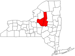
The Utica–Rome Metropolitan Statistical Area, as defined by the United States Census Bureau, is an area consisting of two counties in central New York, anchored by the cities of Utica and Rome (both in Oneida County). As of the 2010 census, the MSA had a population of 299,397.
Utica–Rome | |
|---|---|
 Map of New York highlighting the Utica-Rome Metropolitan Statistical Area. | |
| Country | |
| State | |
| Counties | Herkimer Oneida |
| Population (2010) | |
| • Total | 299,397 |
| • Estimate (2018) | 291,410 |
| • Rank | US: 168 |
Counties
- Oneida (not to confuse with the city of Oneida, New York in the neighbouring Madison County)
- Herkimer
Communities
Places with 10,000 to 30,000 inhabitants
- German Flatts (town)
- Kirkland (town)
- New Hartford (town)
- Whitestown (town)
- Herkimer (town)
Places with 5,000 to 10,000 inhabitants
- Camden (town)
- Frankfort (town)
- Herkimer (village)
- Ilion (village)
- Lee (town)
- Little Falls (city)
- Marcy (town)
- Vernon (town)
- Verona (town)
- Vienna (town)
- Westmoreland (town)
Places with 1,000 to 5,000 inhabitants
|
|
Places with less than 1,000 inhabitants
- Ava (town)
- Barneveld (village)
- Bridgewater (village)
- Clayville (village)
- Cold Brook (village)
- Holland Patent (village)
- Middleville (village)
- Newport (village)
- Norway (town)
- Ohio (town)
- Oneida Castle (village)
- Oriskany Falls (village)
- Poland (village)
- Prospect (village)
- Remsen (village)
- Stark (town)
- West Winfield (village)
Demographics
As of the census[1] of 2000, there were 299,896 people, 116,230 households, and 76,297 families residing within the MSA. The racial makeup of the MSA was 91.85% White, 4.62% African American, 0.23% Native American, 1.00% Asian, 0.02% Pacific Islander, 0.91% from other races, and 1.38% from two or more races. Hispanic or Latino of any race were 2.71% of the population.
The median income for a household in the MSA was $34,417, and the median income for a family was $42,956. Males had a median income of $31,051 versus $22,907 for females. The per capita income for the MSA was $17,329.
Colleges and universities
- Herkimer County
- Oneida County
- Hamilton College, in Clinton
- Mohawk Valley Community College, in Rome and Utica
- State University of New York Polytechnic Institute, in Marcy
- In Utica:
See also
- New York census statistical areas
References
- "U.S. Census website". United States Census Bureau. Retrieved January 31, 2008.
