Utica, Kansas
Utica is a city in Ness County, Kansas, United States. As of the 2010 census, the city population was 158.[6]
Utica, Kansas | |
|---|---|
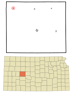 Location within Ness County and Kansas | |
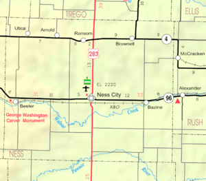 KDOT map of Ness County (legend) | |
| Coordinates: 38°38′34″N 100°10′8″W | |
| Country | United States |
| State | Kansas |
| County | Ness |
| Founded | 1870s |
| Incorporated | 1911 |
| Named for | Utica, New York |
| Area | |
| • Total | 0.24 sq mi (0.63 km2) |
| • Land | 0.24 sq mi (0.63 km2) |
| • Water | 0.00 sq mi (0.00 km2) |
| Elevation | 2,625 ft (800 m) |
| Population | |
| • Total | 158 |
| • Estimate (2019)[3] | 141 |
| • Density | 577.87/sq mi (223.20/km2) |
| Time zone | UTC-6 (CST) |
| • Summer (DST) | UTC-5 (CDT) |
| ZIP code | 67584 |
| Area code | 785 |
| FIPS code | 20-72650 [4] |
| GNIS ID | 0471453 [5] |
History
The first post office in Utica was established in 1879.[7]
Utica was named by early pioneer C.W. Bell who was from Utica, New York.[8]
Geography
Utica is located at 38°38′34″N 100°10′8″W (38.642899, -100.169024).[9] According to the United States Census Bureau, the city has a total area of 0.24 square miles (0.62 km2), all land.[10]
Climate
The climate in this area is characterized by hot, humid summers and generally mild to cool winters. According to the Köppen Climate Classification system, Utica has a humid subtropical climate, abbreviated "Cfa" on climate maps.[11]
Demographics
| Historical population | |||
|---|---|---|---|
| Census | Pop. | %± | |
| 1920 | 285 | — | |
| 1930 | 382 | 34.0% | |
| 1940 | 379 | −0.8% | |
| 1950 | 365 | −3.7% | |
| 1960 | 322 | −11.8% | |
| 1970 | 297 | −7.8% | |
| 1980 | 275 | −7.4% | |
| 1990 | 208 | −24.4% | |
| 2000 | 223 | 7.2% | |
| 2010 | 158 | −29.1% | |
| Est. 2019 | 141 | [3] | −10.8% |
| U.S. Decennial Census | |||
2010 census
As of the census[2] of 2010, there were 158 people, 78 households, and 42 families residing in the city. The population density was 658.3 inhabitants per square mile (254.2/km2). There were 102 housing units at an average density of 425.0 per square mile (164.1/km2). The racial makeup of the city was 95.6% White, 0.6% African American, 0.6% Asian, 1.3% from other races, and 1.9% from two or more races. Hispanic or Latino of any race were 1.3% of the population.
There were 78 households of which 24.4% had children under the age of 18 living with them, 42.3% were married couples living together, 9.0% had a female householder with no husband present, 2.6% had a male householder with no wife present, and 46.2% were non-families. 43.6% of all households were made up of individuals and 20.5% had someone living alone who was 65 years of age or older. The average household size was 2.03 and the average family size was 2.76.
The median age in the city was 47.5 years. 20.9% of residents were under the age of 18; 8.9% were between the ages of 18 and 24; 18.5% were from 25 to 44; 26% were from 45 to 64; and 25.9% were 65 years of age or older. The gender makeup of the city was 46.2% male and 53.8% female.
2000 census
As of the census[4] of 2000, there were 223 people, 94 households, and 53 families residing in the city. The population density was 932.4 people per square mile (358.8/km2). There were 104 housing units at an average density of 434.8 per square mile (167.3/km2). The racial makeup of the city was 99.10% White, and 0.90% from two or more races. Hispanic or Latino of any race were 0.45% of the population.
There were 94 households out of which 24.5% had children under the age of 18 living with them, 48.9% were married couples living together, 4.3% had a female householder with no husband present, and 42.6% were non-families. 39.4% of all households were made up of individuals and 22.3% had someone living alone who was 65 years of age or older. The average household size was 2.37 and the average family size was 3.28.
In the city, the population was spread out with 28.7% under the age of 18, 6.3% from 18 to 24, 23.8% from 25 to 44, 22.0% from 45 to 64, and 19.3% who were 65 years of age or older. The median age was 39 years. For every 100 females, there were 106.5 males. For every 100 females age 18 and over, there were 109.2 males.
The median income for a household in the city was $32,917, and the median income for a family was $36,875. Males had a median income of $27,000 versus $17,083 for females. The per capita income for the city was $15,508. About 13.1% of families and 21.2% of the population were below the poverty line, including 27.3% of those under the age of eighteen and 11.6% of those sixty five or over.
Education
The community is served by Western Plains USD 106 public school district.[12] The Western Plains High School mascot is Bobcats.
Utica High School was closed in 2001.[13] The school district never unified or consolidated with another. The Utica High School mascot was Utica Dragons.[14] Utica Elementary closed in 2004.[13]
References
- "2019 U.S. Gazetteer Files". United States Census Bureau. Retrieved July 24, 2020.
- "U.S. Census website". United States Census Bureau. Retrieved 2012-07-06.
- "Population and Housing Unit Estimates". United States Census Bureau. May 24, 2020. Retrieved May 27, 2020.
- "U.S. Census website". United States Census Bureau. Retrieved 2008-01-31.
- "US Board on Geographic Names". United States Geological Survey. 2007-10-25. Retrieved 2008-01-31.
- "2010 City Population and Housing Occupancy Status". U.S. Census Bureau. Retrieved March 6, 2011.
- "Kansas Post Offices, 1828-1961". Kansas Historical Society. Retrieved 19 June 2014.
- Utica Early History skyways
- "US Gazetteer files: 2010, 2000, and 1990". United States Census Bureau. 2011-02-12. Retrieved 2011-04-23.
- "US Gazetteer files 2010". United States Census Bureau. Archived from the original on 2012-01-25. Retrieved 2012-07-06.
- Climate Summary for Utica, Kansas
- "Western Plains". USD 106. Retrieved 1 January 2017.
- "All About USD 106". Western Plains USD 106. Retrieved 2020-04-29.
- "Dragons Nip Elks", Garden City Telegram, 28 February 1979, p.10.
Further reading
External links
- City
- Maps
- Utica City Map, KDOT
Municipalities and communities of Ness County, Kansas, United States | ||
|---|---|---|
| Cities | 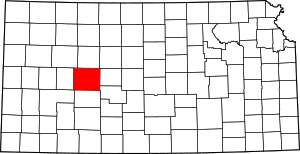 Map of Kansas highlighting Ness County | |
| Unincorporated communities | ||