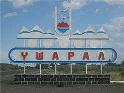
Usharal
Usharal (Kazakh: Үшарал, Úsharal; Russian: Ушарал) is a town in the Alakol District of Almaty Region in south-eastern Kazakhstan. It is the capital of the district. Population: 15,991 (2009 Census results);[1] 15,379 (1999 Census results).[1]
Usharal Үшарал | |
|---|---|
Town | |
 Entrance Sign to the town. | |
 Usharal Location in Kazakhstan | |
| Coordinates: 46°10′11″N 80°56′22″E | |
| Country | Kazakhstan |
| Region | Almaty Region |
| District | Alakol District |
| Population (2009) | |
| • Total | 15,991 |
| Time zone | UTC+6 (Omsk Time) |
| Postal code | 040200 |
| Area code(s) | 72833 |
Climate
| Climate data for Uch-Aral | |||||||||||||
|---|---|---|---|---|---|---|---|---|---|---|---|---|---|
| Month | Jan | Feb | Mar | Apr | May | Jun | Jul | Aug | Sep | Oct | Nov | Dec | Year |
| Average high °C (°F) | −9 (15) |
−7 (20) |
4 (39) |
17 (63) |
24 (76) |
30 (86) |
32 (90) |
31 (87) |
24 (76) |
16 (60) |
3 (38) |
−6 (22) |
13 (56) |
| Average low °C (°F) | −20 (−4) |
−18 (−1) |
−8 (17) |
2 (36) |
9 (48) |
14 (57) |
16 (61) |
14 (57) |
7 (45) |
1 (33) |
−8 (18) |
−16 (4) |
−1 (31) |
| Average precipitation cm (inches) | 2.5 (1) |
1.3 (0.5) |
3.8 (1.5) |
2.3 (0.9) |
1.8 (0.7) |
2.3 (0.9) |
2.8 (1.1) |
1.3 (0.5) |
0.51 (0.2) |
2.8 (1.1) |
3.8 (1.5) |
3.6 (1.4) |
28 (11.2) |
| Source: Weatherbase [2] | |||||||||||||
gollark: Oh, by Faldo.
gollark: Is it claimed?
gollark: Hmm, weird, what's a "MOL"?
gollark: Yes, they do.
gollark: Picturephotograph?
References
- "Население Республики Казахстан" (in Russian). Департамент социальной и демографической статистики. Retrieved 8 December 2013.
- "Weatherbase: Historical Weather for Uch-Aral, Kazakhstan". Weatherbase. 2011. Retrieved on November 24, 2011.
This article is issued from Wikipedia. The text is licensed under Creative Commons - Attribution - Sharealike. Additional terms may apply for the media files.