Ursensollen
Ursensollen is a municipality in the district of Amberg-Sulzbach in Bavaria in Germany.
Ursensollen | |
|---|---|
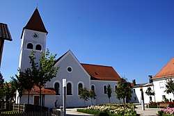 Church of Saint Vitus | |
 Coat of arms | |
Location of Ursensollen within Amberg-Sulzbach district 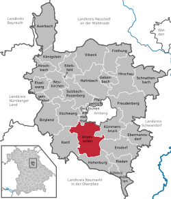 | |
 Ursensollen  Ursensollen | |
| Coordinates: 49°24′4″N 11°45′28″E | |
| Country | Germany |
| State | Bavaria |
| Admin. region | Oberpfalz |
| District | Amberg-Sulzbach |
| Government | |
| • Mayor | Franz Mädler (FW) |
| Area | |
| • Total | 72.91 km2 (28.15 sq mi) |
| Elevation | 537 m (1,762 ft) |
| Population (2018-12-31)[1] | |
| • Total | 3,718 |
| • Density | 51/km2 (130/sq mi) |
| Time zone | CET/CEST (UTC+1/+2) |
| Postal codes | 92289 |
| Dialling codes | 09628 |
| Vehicle registration | AS |
| Website | https://www.ursensollen.de/ |
Geography
Ursensollen is in the region Upper Palatinate-North about 10 km to the west of Amberg.
The following districts belong to this town: Allmannsfeld, Bittenbrunn, Egelhofen, Eigentshofen, Ehringsfeld, Erlheim, Garsdorf, Götzendorf, Gunzelsdorf, Guttenberg, Haag, Hausen, Häuslöd, Heimhof, Heinzhof, Hohenkemnath, Inselsberg, Kemnatheröd, Kotzheim, Littenschwang, Oberhof, Oberleinsiedl, Ödallerzhof, Reinbrunn, Reusch, Richt, Richtheim, Rückertshof, Salleröd, Sauheim, Stockau, Thonhausen, Ullersberg, Unterleinsiedl, Ursensollen, Wappersdorf, Weiherzant, Winkl, Wollenzhofen, Zant.
Population
The districts of the town had a population of 2,678 in 1970, 3,518 in 2000, and 3,745 in 2009.
References
- "Fortschreibung des Bevölkerungsstandes". Bayerisches Landesamt für Statistik und Datenverarbeitung (in German). July 2019.
Towns and municipalities in Amberg-Sulzbach | ||
|---|---|---|
| Coat of Arms of Amberg-Sulzbach district | |
| Authority control |
|
|---|