Hirschau
Hirschau is a municipality in the Amberg-Sulzbach district, Upper Palatinate, Bavaria, Germany.
Hirschau | |
|---|---|
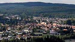 Hirschau seen from Monte Kaolino | |
 Coat of arms | |
Location of Hirschau within Amberg-Sulzbach district 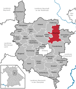 | |
 Hirschau  Hirschau | |
| Coordinates: 49°32′N 11°57′E | |
| Country | Germany |
| State | Bavaria |
| Admin. region | Upper Palatinate |
| District | Amberg-Sulzbach |
| Government | |
| • Mayor | Hermann Falk (CSU) |
| Area | |
| • Total | 74.90 km2 (28.92 sq mi) |
| Elevation | 411 m (1,348 ft) |
| Population (2018-12-31)[1] | |
| • Total | 5,629 |
| • Density | 75/km2 (190/sq mi) |
| Time zone | CET/CEST (UTC+1/+2) |
| Postal codes | 92242 |
| Dialling codes | 09622 |
| Vehicle registration | AS |
| Website | hirschau.de |
Geography
Hirschau lies directly on the Bundesstraße 14 (Nuremberg - Rozvadov), 13 km northeast of Amberg and about 65 km east of Nuremberg. Apart from the main village Hirschau, the municipality consists of the following villages:
- Burgstall
- Dienhof
- Ehenfeld
- Krickelsdorf
- Kricklhof
- Krondorf
- Massenricht
- Obersteinbach
- Steiningloh
- Untersteinbach
- Weiher
Economy
Kaolin, used for the production of porcelain, has been mined at Hirschau since 1901. Interesting is the Monte Kaolino, a 120 meter high mound made from 32,000,000 tons of quartz sand from excess sand in years of operation. It is now used as a (sand) skiing/camping resort during the summer months. It is also the place where the yearly Sandboarding Championships are held.
gollark: I doubt they've totally cancelled the discrete graphics thing, there's a contract for them in a supercomputer, but it will probably be very late.
gollark: They do have their own ones derived from AMD's, I think, also.
gollark: Oh yes, I heard they were doing *something*.
gollark: And getting people to switch to alternate architectures without backward compatibility has not really worked well in the past.
gollark: The CPU scene is kind of not very good because there are only two companies with access to x86 intellectual property.
References
- "Fortschreibung des Bevölkerungsstandes". Bayerisches Landesamt für Statistik und Datenverarbeitung (in German). July 2019.
Towns and municipalities in Amberg-Sulzbach | ||
|---|---|---|
| Coat of Arms of Amberg-Sulzbach district | |
| Authority control |
|
|---|
This article is issued from Wikipedia. The text is licensed under Creative Commons - Attribution - Sharealike. Additional terms may apply for the media files.