Uppinangady
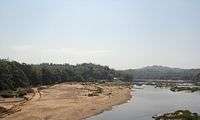
Uppinangady or Ubar is a town in the Dakshina Kannada district in the state of Karnataka. It is surrounded by the Kumaradhara River on one side and Nethravathi River on the other. When the town's two surrounding rivers rise during the rainy season and meet, this is called the "Sangam" which is a Sanskrit word for confluence. The Sangam is a major event as people from the surrounding villages crowd the river banks to witness the merge. The population of Uppinangady is 7,172.
Uppinangady Ubar | |
|---|---|
Town | |
 Uppinangady Bridge | |
 Uppinangady Location in Karnataka, India | |
| Coordinates: 12.839972°N 75.248982°E | |
| Country | |
| State | Karnataka |
| District | Dakshina Kannada |
| Government | |
| • Body | Grama Panchayath, Nadakacheri |
| Languages | |
| • Official | Tulu, Kannada, Beary |
| Time zone | UTC+5:30 (IST) |
| PIN | 574 241 |
| Telephone code | 08251 |


In 1923 the town of Uppinangady was washed out due to excessive flooding, and its courts were moved to Puttur. Severe flooding also occurred in 1974.
The town of Uppinangady is situated at an altitude of 53 meters. Uppinangady is also known as "Dakshina Kashi". It is believed that there is also a sangam of a third river along with the other two rivers which is known as Guptagamini.
Transport
Uppinangady is at the foothills of the Western Ghats in Dakhshina Kannada district, surrounded by forests. Uppinangady lies on National Highway 75 which connects Mangaluru to Bengaluru. There are frequent bus and taxi service from this place to Mangaluru and its taluk headquarters Puttur and also to Kukke Subramanya. The nearest railway station is Puttur Railway station located at a distance of 12 km. The nearest airport is Mangalore International airport 55 km away.
References
External links
| Wikimedia Commons has media related to Uppinangady. |
- http://www.fallingrain.com/world/IN/19/Uppinangadi.html
- Herald A. Stewart, A Handbook to South Kanara, 1895
- http://www.sunmediaonline.com/indiachroniclenovember/travel.html
- South Canara Gazetteers 1894,1938,1973