Unterspreewald
Unterspreewald is a municipality in the district of Dahme-Spreewald in Brandenburg in Germany.
Unterspreewald | |
|---|---|
Location of Unterspreewald within Dahme-Spreewald district  | |
 Unterspreewald  Unterspreewald | |
| Coordinates: 52°05′00″N 13°52′00″E | |
| Country | Germany |
| State | Brandenburg |
| District | Dahme-Spreewald |
| Municipal assoc. | Unterspreewald |
| Subdivisions | 3 Ortsteile |
| Government | |
| • Mayor | Arno Pötschick |
| Area | |
| • Total | 25.8 km2 (10.0 sq mi) |
| Elevation | 72 m (236 ft) |
| Population (2018-12-31)[1] | |
| • Total | 796 |
| • Density | 31/km2 (80/sq mi) |
| Time zone | CET/CEST (UTC+1/+2) |
| Postal codes | 15910 |
| Dialling codes | 035473 |
| Vehicle registration | LDS |
| Website | www.unterspreewald.de |
Demography
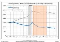
Development of population since 1875 within the current boundaries (Blue line: Population; Dotted line: Comparison to population development of Brandenburg state; Grey background: Time of Nazi rule; Red background: Time of communist rule)
|
|
|
gollark: Subframe electronics or something.
gollark: Observe, my laser. It accelerates light to speeds so high that it's not actually rendered.
gollark: With great difficulty, or subframe?
gollark: Oh, right. You're limited to however much fits on the screen.
gollark: moev?
References
- "Bevölkerung im Land Brandenburg nach amtsfreien Gemeinden, Ämtern und Gemeinden 31. Dezember 2018". Amt für Statistik Berlin-Brandenburg (in German). July 2019.
- Detailed data sources are to be found in the Wikimedia Commons.Population Projection Brandenburg at Wikimedia Commons
| Authority control |
|
|---|
This article is issued from Wikipedia. The text is licensed under Creative Commons - Attribution - Sharealike. Additional terms may apply for the media files.