Rietzneuendorf-Staakow
Rietzneuendorf-Staakow is a municipality in the district of Dahme-Spreewald in Brandenburg in Germany.
Rietzneuendorf-Staakow | |
|---|---|
Location of Rietzneuendorf-Staakow within Dahme-Spreewald district  | |
 Rietzneuendorf-Staakow  Rietzneuendorf-Staakow | |
| Coordinates: 52°01′00″N 13°40′00″E | |
| Country | Germany |
| State | Brandenburg |
| District | Dahme-Spreewald |
| Municipal assoc. | Unterspreewald |
| Subdivisions | 3 Ortsteile |
| Government | |
| • Mayor | Ingrid Schuknecht |
| Area | |
| • Total | 27.99 km2 (10.81 sq mi) |
| Elevation | 52 m (171 ft) |
| Population (2018-12-31)[1] | |
| • Total | 599 |
| • Density | 21/km2 (55/sq mi) |
| Time zone | CET/CEST (UTC+1/+2) |
| Postal codes | 15910 |
| Dialling codes | 035477 |
| Vehicle registration | LDS |
| Website | www.unterspreewald.de |
Demography
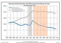
Development of population since 1875 within the current boundaries (Blue line: Population; Dotted line: Comparison to population development of Brandenburg state; Grey background: Time of Nazi rule; Red background: Time of communist rule)
|
|
|
gollark: The only thing to fear is the fear that fear is to be feared.
gollark: ddg! bee attacks
gollark: <@319753218592866315> PureScript is not haskell.
gollark: no.
gollark: It might. Don't risk it.
References
- "Bevölkerung im Land Brandenburg nach amtsfreien Gemeinden, Ämtern und Gemeinden 31. Dezember 2018". Amt für Statistik Berlin-Brandenburg (in German). July 2019.
- Detailed data sources are to be found in the Wikimedia Commons.Population Projection Brandenburg at Wikimedia Commons
| Authority control |
|
|---|
This article is issued from Wikipedia. The text is licensed under Creative Commons - Attribution - Sharealike. Additional terms may apply for the media files.