Union, Indiana
Union is an unincorporated community in Clay Township, Pike County, in the U.S. state of Indiana.[2]
Union, Indiana | |
|---|---|
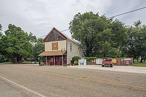 | |
 Union  Union | |
| Coordinates: 38°27′55″N 87°26′05″W | |
| Country | United States |
| State | Indiana |
| County | Pike |
| Township | Clay |
| Elevation | 469 ft (143 m) |
| Time zone | UTC-5 (Eastern (EST)) |
| • Summer (DST) | UTC-4 (EDT) |
| ZIP code | 47640 |
| Area code(s) | 812 |
| GNIS feature ID | 445046 |
History
A post office was established at Union in 1845, and remained in operation until 1955.[3] The community may be named after Uniontown, Pennsylvania, the native home of an early settler.[4]
Geography
Union is located at 38°27′55″N 87°26′05″W.
gollark: Pheenixm#0596.
gollark: There is actually someone here working on memristor neural network hardware, apparently.
gollark: Good [TIME OF DAY].
gollark: It probably just pulls from the same APIs as Google Maps. Maybe you could make a clone using that.
gollark: On another server I'm on we have moderator, "moderator", ""moderator", """moderator""", and """"moderator"""". Clearly this place should do that with administrator!
References
- "US Board on Geographic Names". United States Geological Survey. October 25, 2007. Retrieved 2016-11-17.
- U.S. Geological Survey Geographic Names Information System: Union, Indiana
- "Pike County". Jim Forte Postal History. Retrieved 5 October 2015.
- Baker, Ronald L. (October 1995). From Needmore to Prosperity: Hoosier Place Names in Folklore and History. Indiana University Press. p. 329. ISBN 978-0-253-32866-3.
Allegedly James Oliphant named this village for his hometown, Unionville, Pennsylvania.
Municipalities and communities of Pike County, Indiana, United States | ||
|---|---|---|
| City | Map of Indiana highlighting Pike County | |
| Towns | ||
| Townships | ||
| CDP | ||
| Other unincorporated communities |
| |
| Footnotes | ‡This populated place also has portions in an adjacent county or counties | |
This article is issued from Wikipedia. The text is licensed under Creative Commons - Attribution - Sharealike. Additional terms may apply for the media files.