U.S. Route 220 in West Virginia
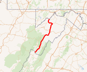
U.S. Route 220 (US 220) is a U.S. Highway that travels from Rockingham, North Carolina, to Waverly, New York. In the state of West Virginia, it travels for 93 miles (150 km) from the Virginia state line two miles (3.2 km) south of Harper to the Maryland state line at Keyser.
| ||||
|---|---|---|---|---|

US 220 highlighted in red | ||||
| Route information | ||||
| Maintained by WVDOH | ||||
| Length | 93 mi (150 km) | |||
| Existed | 1926–present | |||
| Major junctions | ||||
| South end | ||||
| North end | ||||
| Location | ||||
| Counties | Pendleton, Grant, Hardy, Hampshire, Mineral | |||
| Highway system | ||||
| ||||
Route description
_near_Potomac_Avenue_in_Petersburg%2C_Grant_County%2C_West_Virginia.jpg)
The highway enters West Virginia two miles (3.2 km) south of Harper in Pendleton County. From the state line, US 220 parallels the South Branch Potomac River as it progresses northward. 13 miles (21 km) north of Harper, US 220 travels through Franklin, where it intersects US 33. The highway enters Grant County approximately 17 miles (27 km) north of Franklin.
Within Grant County, US 220 intersects the concurrent routes of West Virginia Route 28 (WV 28) and WV 55 in Petersburg. The two state highways join US 220 eastward into Hardy County. WV 28 and WV 55 remain concurrent to Moorefield, where WV 55 splits from US 220/WV 28. North of Moorefield, US 220/WV 28 intersects the future right-of-way of US 48. US 220 and WV 28 remain concurrent into Hampshire County, where they meet US 50 in Junction. WV 28 departs US 220, following US 50 to the east, while US 220 joins US 50 westward into Mineral County. This stretch of US 220 is known as the Northwestern Turnpike.
At the top of Knobly Mountain northwest of Ridgeville, US 220 splits from US 50 and resumes a northerly alignment as it descends into the New Creek Valley. It is known as Cut Off Road south of WV 93 and New Creek Drive from there to Keyser, the county seat of Mineral County, where it becomes known as Mineral Street. In the center of the city, located seven miles (11 km) north of US 50, US 220 intersects WV 46. At the northern edge of Keyser, US 220 crosses the North Branch Potomac River via Memorial Bridge, leaving West Virginia and entering Maryland.
Junction list
| County | Location | mi | km | Exit | Destinations | Notes |
|---|---|---|---|---|---|---|
| Pendleton | Harper | 0.00 | 0.00 | Continuation into Virginia | ||
| Franklin | Southern end of US 33 concurrency; access to James Madison University | |||||
| Northern end of US 33 concurrency; access to Spruce Knob, the highest point in West Virginia | ||||||
| Grant | Petersburg | Southern end of WV 28 and WV 55 concurrencies | ||||
| Hardy | | US 220 South Branch Potomac River Bridge #1 | ||||
| Moorefield | Northern end of WV 55 concurrency | |||||
| | US 220 South Branch Potomac River Bridge #2 | |||||
| Hampshire | Junction | Northern end of WV 28 concurrency; southern end of US 50 concurrency | ||||
| Mineral | New Creek | Northern end of US 50 concurrency | ||||
| Eastern terminus of WV 93 | ||||||
| Keyser | ||||||
| 93 | 150 | Continuation into Maryland at the Potomac River | ||||
1.000 mi = 1.609 km; 1.000 km = 0.621 mi
| ||||||
See also

References
External links
| Wikimedia Commons has media related to U.S. Route 220 in West Virginia. |
