Typhoon Gay (1989)
Typhoon Gay, also known as the Kavali Cyclone of 1989,[1] was a small but powerful tropical cyclone that caused more than 800 fatalities in and around the Gulf of Thailand in November 1989. The worst typhoon to affect the Malay Peninsula in 35 years, Gay originated from a monsoon trough over the Gulf of Thailand in early-November. Owing to favorable atmospheric conditions, the storm rapidly intensified, attaining winds of more than 120 km/h (75 mph) by 3 November.[nb 1] Later that day, Gay became the first typhoon since 1891 to make landfall in Thailand, striking Chumphon Province with winds of 185 km/h (115 mph). The small storm emerged into the Bay of Bengal and gradually reorganized over the following days as it approached southeastern India. On 8 November, Gay attained its peak intensity as a Category 5–equivalent cyclone with winds of 260 km/h (160 mph). The typhoon then moved ashore near Kavali, Andhra Pradesh. Rapid weakening ensued inland, and Gay dissipated over Maharashtra early on 10 November.
| Super cyclonic storm (IMD scale) | |
|---|---|
| Category 5 tropical cyclone (SSHWS) | |
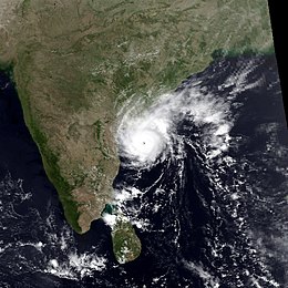
 Gay at peak intensity before making landfall on India, on 8 November 1989 | |
| Formed | 1 November 1989 |
| Dissipated | 10 November 1989 |
| Highest winds | 3-minute sustained: 230 km/h (145 mph) 1-minute sustained: 260 km/h (160 mph) |
| Lowest pressure | 930 hPa (mbar); 27.46 inHg |
| Fatalities | 1,036 total |
| Damage | $521 million (1989 USD) |
| Areas affected | Thailand, Myanmar, India |
| Part of the 1989 Pacific typhoon and North Indian Ocean cyclone seasons | |
The typhoon's rapid development took hundreds of vessels in the Gulf of Thailand by surprise, leading to 275 offshore fatalities. Of these, 91 occurred after an oil drilling ship, the Seacrest, capsized amid 6–11 m (20–36 ft) swells. Across the Malay Peninsula, 588 people died from various storm-related incidents. Several towns in coastal Chumphon were destroyed. Losses throughout Thailand totaled ฿11 billion (US$497 million).[nb 2] Striking India as a powerful cyclone, Gay damaged or destroyed about 20,000 homes in Andhra Pradesh, leaving 100,000 people homeless. In that country, 69 deaths and ₹410 million (US$25.3 million) in damage were attributed to Gay.
Meteorological history

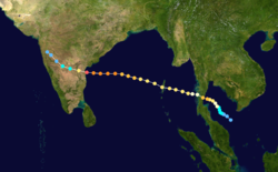
In early November, a monsoon trough over the Gulf of Thailand showed signs of tropical cyclogenesis. A small, concentrated area of convection quickly developed over a low-pressure area within the trough, and on November 2, the system became sufficiently organized for the Joint Typhoon Warning Center (JTWC) to issue a Tropical Cyclone Formation Alert.[nb 3] Owing to its small size, the system began strengthening within the narrow gulf by taking advantage of warm waters and good outflow. Moving generally northwestward, it became a tropical depression later that day and underwent rapid intensification. As the newly named Tropical Storm Gay strengthened, it "presented a paradox to forecasters", according to Lieutenant Dianne K. Crittenden; synoptic data from Malaysia and Thailand indicated decreasing wind speeds and increasing barometric pressures around the storm, but these observations were later interpreted as increased subsidence.[3]
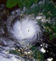
Strengthening faster than anticipated, Gay attained typhoon status early on 3 November. Later that day, the storm developed an eye before passing over the Seacrest, an oil drilling ship.[3] On 4 November, Gay's winds increased to 185 km/h (115 mph), equivalent to a Category 3 hurricane on the Saffir–Simpson Hurricane Scale, before making landfall in Chumphon Province, Thailand, at 0600 UTC.[4] The Japan Meteorological Agency assessed that the storm had ten-minute sustained winds of 140 km/h (85 mph) and a pressure of 960 mbar (hPa; 28.35 inHg).[5][nb 4] Crossing the Kra Isthmus, Gay weakened to minimal typhoon status as it entered the Bay of Bengal.[3][4] According to the India Meteorological Department (IMD),[nb 5] Gay was the first typhoon since 1891 to form in the Gulf of Thailand and enter the Bay of Bengal.[8] Responding to a ridge to its north, Gay maintained a west-northwestward to northwestward track for the next four days. The storm gradually restrengthened as it moved through an area of low wind shear and warm waters; however, this was limited by restrictions to the cyclone's outflow.[3] Early on November 6, Gay passed near the Andaman Islands as a Category 2-equivalent cyclone.[4]

After changing little in intensity for much of 6 November, Gay strengthened as the ridge to its north intensified and the previous restrictions to its outflow diminished. The storm moved due west through a small fetch of warmer waters, fueling the process of intensification over the next 42 hours. Based on estimates provided through the use of the Dvorak technique, the JTWC assessed Gay to have attained its peak intensity as a Category 5-equivalent cyclone with winds of 260 km/h (160 mph) early on November 8.[3][4] Around this time, the IMD estimated that the storm had three-minute sustained winds of 240 km/h (145 mph), classifying Gay as a modern-day Super Cyclonic Storm.[1][9] Additionally, the agency estimated the cyclone's central pressure to have decreased to 930 mbar (hPa; 27.46 inHg).[10] Around 1800 UTC, Gay made landfall over a sparsely populated area near Kavali, India, in Andhra Pradesh. Upon coming ashore, the storm's eye was about 20 km (12 mi) wide, with gale-force winds within 95 km (60 mi) of the center.[3][11] Now over land, Gay no longer had access to warm waters, causing it to weaken to a tropical storm less than 12 hours after landfall.[3] The storm continued to deteriorate while moving across India, before it completely dissipated over Maharashtra on 10 November.[4]
Impact and aftermath
Gulf of Thailand
The most powerful storm to affect the Gulf of Thailand in more than 35 years, Gay produced 6–11 m (20–36 ft) swells that caught many ships in the region off-guard.[12] At least 16 vessels were reported missing by 5 November, including the 106 m (348 ft) Unocal Corporation oil drilling ship Seacrest.[13] According to survivors, the vessel received no warning of the developing typhoon.[14] Just when all crew members were about to abandon ship, the eye of Typhoon Gay passed over. Winds fluctuated violently and changed direction, preventing the ship from remaining stabilized despite being within safe operating limits. The vessel abruptly capsized with all 97 crew members on board during the overnight hours of 3 November, before any life boats could be deployed.[13][14] Initial rescue attempts on 4 November were hampered by rough seas.[15] Two days after the sinking, four rescue ships and two helicopters in the region were searching for survivors;[13] four people were rescued from the wreckage on 6 November. Divers from the Thai Navy were sent to search the capsized vessel for anyone trapped inside.[16] Of the crew, only 6 survived; 25 bodies were recovered, and the remaining 66 members were presumed dead.[14][17] Losses from the sinking of the Seacrest totaled $40 million.[18] Another 20 cargo and fishing ships sank during the storm, resulting in 140 fatalities.[19]
Thailand

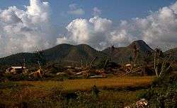
Striking Thailand with unprecedented strength, Typhoon Gay caused catastrophic damage across many of its provinces.[12] Areas between Chumphon and Rayong Provinces were severely affected by heavy rains, high winds and large swells.[21] Rainfall amounts peaked at Chumphon, where 7.64 inches (194 mm) fell during the cyclone's passage.[22] Widespread disruption of communication and electricity occurred in most areas south of Bangkok; many households remained without power for weeks.[23] Damaging winds uprooted numerous trees and power poles and toppled wooden houses built on stilts.[24] Exacerbated by deforestation,[20] flash flooding triggered by the storm damaged or destroyed thousands of homes and caused at least 365 fatalities.[25] Several towns and villages across Chumphon province were devastated, and one of the destroyed villages "looked like it had been bombed" according to the Bangkok Post.[26] Entire districts were reportedly "flattened" in Chumphon and Prachuap Khiri Khan Provinces.[24] The typhoon destroyed many schools across Chumphon and Surat Thani Provinces, many of which were constructed of wood. All structures close to the storm's path had their windows and doors blown out, and some multi-story buildings lost their upper floors. A few schools constructed from reinforced concrete sustained little damage.[27] Over 1,000 roads and 194 bridges were damaged or washed away.[20] At the height of the floods, over 250,000 hectares (618,000 acres) of land was under water.[28] Onshore, 558 fatalities were attributed to the storm, and another 44 took place just offshore.[20] Throughout Thailand, approximately 47,000 homes were damaged or destroyed, and over 200,000 people were affected, of which about 153,000 were left homeless.[20][28] Monetary losses reached 11 billion baht (US$456.5 million), ranking Gay as one of the costliest disasters in the country's history.[29]
Within a week of the storm's passage, the Government of Thailand began distributing relief goods to residents throughout the affected provinces.[23] Despite the effort by the government, 2,500 people from Pa Thiew and Tha Sae demonstrated for additional and more intensive aid on 9 November. These protests were soon dispersed.[30] Following considerable criticism for downplaying the impact of the typhoon, Prime Minister Chatichai Choonhavan delayed his visit to the United States to oversee relief efforts.[25] By 15 November the United States pledged to donate US$25,000 for recovery operations. Telephone connection was restored from Bangkok to Prachuap Khiri Khan by this time; however, areas further south remained disconnected. Generators were brought in to keep hospitals and government offices running since much of Chumphon Province remained without electricity for more than two weeks. As the scale of damage became more apparent, a request for international aid was made by 17 November to the United Nations Disaster Relief Organization. Upon the announcement of the request, six countries pledged to provide nearly US$510,000 in funds collectively.[20][23] Agriculture across Surat Thani Province was severely affected by the typhoon in the long-term as well. In the four years following Typhoon Gay, land use for orchards, rubber, and oil palm plantations decreased from 33.32 percent to 30.53 percent. Additionally, rice paddy coverage decreased from 22.96 percent to 13.03 percent.[31]
Following post-storm surveys, it was determined that most of the severely damaged schools were built improperly and the upper-floors were not designed to bear typhoon-force winds. According to building codes in Thailand, structures are mandated to be able to withstand up to 120 kgf/m2 of pressure from winds. In the years following the typhoon, studies by engineers were conducted in the hardest hit regions to determine how to best rebuild structures in the country. With many of the destroyed structures being constructed from wood, reinforced concrete structures were the suggested replacement. The new buildings could last up to 50 years with proper construction; however, sub-standard building would result in a need for repairs within five years.[27]
India
After crossing the Malay Peninsula, Typhoon Gay moved through the Andaman Islands on November 6. As a precautionary measure, all air and sea traffic were suspended to the region. Winds in excess of 120 km/h (75 mph) battered North Andaman Island, causing two structures to collapse.[8] A few days before Typhoon Gay made landfall, officials in Andhra Pradesh began evacuating roughly 50,000 residents along the coast and stockpiled relief goods. Some people were forced to leave vulnerable locations in the Visakhapatnam and Srikakulam districts.[32][33] Local meteorologists warned that the storm was comparable to a cyclone in 1977 that killed more than 10,000 people.[34] Striking the southern coast of Andhra Pradesh, Typhoon Gay produced wind gusts estimated at 320 km/h (200 mph).[35] Along the coast, a storm surge of 3.5 m (11 ft) inundated areas up to 3 km (1.9 mi) inland, washing away numerous structures.[10][36] About 20 km (12 mi) outside of Kavali, a 91 m (299 ft) tall, steel lattice microwave tower collapsed after experiencing winds estimated at 142 km/h (88 mph).[37] Transportation and communication across the region was disrupted and 20,000 homes were damaged or destroyed, leaving at least 100,000 people homeless.[38] Nearly every structure in Annagaripalem were severely damaged or destroyed.[39] Offshore, 25 fishermen drowned near Machilipatnam after ignoring warnings to return to port.[40] Throughout Andhra Pradesh, 69 fatalities and ₹410 million (US$25.3 million) worth of damage was attributed to Typhoon Gay.[10][41] In the months after the storm, concrete shelters were built to house displaced persons.[39]
See also
- List of the most intense tropical cyclones in the Northern Indian Ocean
- Cyclone Forrest
- Tropical Storm Podul (2013)
- Tropical Depression Wilma (2013)
- Hurricane Andrew (1992) - Another small but powerful tropical cyclone
Notes
- All sustained wind speeds are based on 1-minute standards unless otherwise stated.
- All damage figures in the article are in 1989 United States dollars (USD) unless otherwise stated.
- The Joint Typhoon Warning Center is a joint United States Navy – United States Air Force task force that issues tropical cyclone warnings for the western Pacific Ocean and other regions.[2]
- The Japan Meteorological Agency is the official Regional Specialized Meteorological Center for the western Pacific Ocean.[6]
- The India Meteorological Department is the official Regional Specialized Meteorological Center for the northern Indian Ocean.[7]
References
- G.S. Mandal & Akhilesh Gupta (1996). "The Wind Structure, Size and Damage Potential of Some Recent Cyclone of Hurricane Intensity in the North Indian Ocean". Advances in Tropical Meteorology. New Delhi, India: Indian Meteorological Society (50): 421.
- "Joint Typhoon Warning Center Mission Statement". Joint Typhoon Warning Center. United States Navy. 2011. Archived from the original on July 26, 2007. Retrieved December 25, 2011.
- Lt. Dianne K. Crittenden (1990). "1989 Annual Tropical Cyclone Report: Typhoon Gay (32W)" (PDF). Joint Typhoon Warning Center. United States Navy. pp. 166–172. Retrieved December 25, 2011.
- "Typhoon 32W Best Track" (.TXT). Joint Typhoon Warning Center. United States Navy. 1990. Retrieved December 25, 2011.
- Japan Meteorological Agency (October 10, 1992). "RSMC Best Track Data – 1980–1989". Archived from the original (.TXT) on December 5, 2014. Retrieved December 25, 2011.
- "Annual Report on Activities of the RSMC Tokyo – Typhoon Center 2000" (PDF). Japan Meteorological Agency. February 2001. p. 3. Retrieved December 25, 2011.
- "RSMCs and TCWCs". World Meteorological Organization. 2011. Retrieved December 25, 2011.
- "Cyclone Hits India's Andaman Islands". New Delhi, India: Xinhua General News Service. November 6, 1989. – via Lexis Nexis (subscription required)
- "Cyclones, storm surges, floods, landslides" (PDF). Global Facility for Disaster Reduction and Recovery. September 2011. p. 9. Archived from the original (PDF) on April 26, 2012. Retrieved December 17, 2011.
- S. Raghavan & S. Rajesh (May 2003). "Trends in Tropical Cyclone Impact: A Study in Andhra Pradesh, India". Bulletin of the American Meteorological Society. 85 (5): 635–644. Bibcode:2003BAMS...84..635R. doi:10.1175/BAMS-84-5-635.
- A. Muthuchami & P. Chanavanthan (2005). "The Relation between Size of the Storm and the Size of the Eye". Predicting Mathematical Events. New Delhi, India: 104.
- Suphat Vongvisessomjai (February 2009). "Tropical cyclone disasters in the Gulf of Thailand" (PDF). Songklanakarin Journal of Science and Technology. Bangkok, Thailand. 31 (2): 213. Archived from the original (PDF) on April 25, 2012. Retrieved December 14, 2011.
- "Aussies Lost As Oil Ship Capsizes". The Sun Herald. Sydney, Australia. November 5, 1989. p. 5. – via Lexis Nexis (subscription required)
- "Unocal may scuttle Seacrest; only six survive". Oil & Gas Journal. November 20, 1989. p. 43. – via Lexis Nexis (subscription required)
- "Divers Search Ship". The Washington Post. November 5, 1989. p. A39. – via Lexis Nexis (subscription required)
- Thomas Perry (November 6, 1989). "4 Survivors Rescued From Capsized Oil Ship In Gulf Of Thailand". The Globe and Mail. Canada. – via Lexis Nexis (subscription required)
- "250 feared killed by Typhoon Gay". The Independent. London, England. November 6, 1989. p. 10. – via Lexis Nexis (subscription required)
- Neale Prior & Malcolm Brown (November 6, 1989). "Hope Fades for Missing Drillers". The Sydney Morning Herald. Sydney, Australia. p. 6. – via Lexis Nexis (subscription required)
- Neil Kelly (November 6, 1989). "Typhoon in Thailand claims 250 victims". The Times. London, England. – via Lexis Nexis (subscription required)
- Vipa Rungdilokroajn (February 1990). Natural Disasters in Thailand (PDF) (Report). Bangkok, Thailand: Universidad Nacional Autónoma de Nicaragua. Archived from the original (PDF) on April 26, 2012. Retrieved December 16, 2011.
- "Captain stayed to fight storm". Hobart Mercury. Reuters. November 8, 1989. – via Lexis Nexis (subscription required)
- Roth, David M. (October 18, 2017). "Tropical Cyclone Point Maxima". Tropical Cyclone Rainfall Data. United States Weather Prediction Center. Retrieved November 26, 2017.
- "Thailand Typhoon Gay Nov 1989 UNDRO Information Report 1–4". United Nations Department of Humanitarian Affairs. ReliefWeb. November 21, 1989. Retrieved December 14, 2011.
- "Frantic hunt for victims of Thai typhoon". Hobart Mercury. Bangkok, Thailand. Agence France-Presse. November 7, 1989. – via Lexis Nexis (subscription required)
- "360 Die in Flash Floods; Thailand". The Sun Herald. Sydney, Australia. November 12, 1989. p. 9. – via Lexis Nexis (subscription required)
- "Typhoon Brings Mayhem". Sydney Morning Herald. Bangkok, Thailand. Associated Press. November 6, 1989. p. 14. – via Lexis Nexis (subscription required)
- Kriangsak Charanyanond (1996). "Multi-Purpose Buildings for Disaster Situations in Thailand" (PDF). United Nations Educational, Scientific and Cultural Organization. Retrieved April 2, 2012.
- Manu Omakupt (August 1992). "Application of Remote Sensing and GIS for Renewable Resources Damaged by Typhoon 'Gay': Chumphon Province" (PDF). Thailand: International Society for Photogrammetry and Remote Sensing. Retrieved December 16, 2011.
- "Thailand Country Report". Asian Disaster Reduction Center. 1998. Retrieved December 15, 2011.
- "Rage of typhoon victims". Hobart Mercury. Bangkok, Thailand. Agence France-Presse. November 9, 1989. – via Lexis Nexis (subscription required)
- Absornsuda Siripong; Wish Siripong & Takashige Sugimoto (1997). "Landuse changes at Surat Thani, Southern Thailand from 1973 to 1993". Chulalongkorn University Faculty of Science, Department of Marine Science. Retrieved April 2, 2012.
- "Typhoon's toll: some 200 dead, 20,000 homeless". The Vindicator. United Press International. November 9, 1989. p. 36. Retrieved December 17, 2011.
- "Typhoon Threatens Crowded Coast of India". Los Angeles Times. Bangkok, Thailand. United Press International. November 9, 1989. Retrieved December 15, 2011.
- Paul Wedel (November 8, 1989). "Typhoon Gay heads toward India". Bangkok, Thailand: United Press International. – via Lexis Nexis (subscription required)
- "Weather World: India hit by 200mph winds". The Guardian. London, England. November 14, 1989. – via Lexis Nexis (subscription required)
- A. D. Rao (November 2006). "On recent developments in storm surge inundation modelling" (PDF). Centre for Atmospheric Sciences. Archived from the original (PDF) on May 12, 2013. Retrieved December 17, 2011.
- A. Abraham; P. Harikrishna; S. Gomathinayagam; N. Lakshmanan (September 2005). "Failure investigation of microwave towers during cyclones — A case study". Journal of Structural Engineering. 32 (3): 147–157.
- "Typhoon Death Toll Rises; 500 Missing Off Thailand Coast". Los Angeles Times. Los Angeles, California. Reuters. November 11, 1989. Retrieved December 15, 2011.
- "Case No.E5/3311/2009". Orders of Joint Collector. December 12, 2009. Archived from the original (.DOC) on April 23, 2012. Retrieved December 17, 2011.
- "Cyclone Kills 25". New Delhi, India: Associated Press. November 9, 1989. – via Lexis Nexis (subscription required)
- "Historical records of Severe Cyclones which formed in the Bay of Bengal and made landfall at the eastern coast of India during the period from 1970–1999". India Meteorological Department. 1999. Archived from the original on September 25, 2014. Retrieved December 17, 2011.
