Typhoon Agnes (1981)
Typhoon Agnes, known in the Philippines as Typhoon Pining, produced among the heaviest rains recorded during the 20th century in South Korea, with 710 mm (28 in) falling over a two-day span. The storm originated as a tropical depression near Guam on August 25, 1981. Moving along a west-northwest to northwest track, the system gradually strengthened as deep convection organized around it. The depression was assigned the name Agnes on August 27 following the development of gale-force winds. Further intensification to typhoon-status occurred by August 29. Agnes attained its peak intensity on August 31 over the East China Sea as a Category 2-equivalent on the Saffir–Simpson hurricane wind scale with winds of 175 km/h (110 mph).[nb 1] Subsequent interaction with a mid-latitude trough induced an extratropical transition as the cyclone slowed and turned north. The system had lost most of its tropical characteristics by September 1, with the majority of convection sheared northeast over South Korea and Japan. Agnes later accelerated northeast and completed its transition on September 3. The remnants continued along this course, impacting northern Japan and the Kamchatka Peninsula before last being noted on September 6 near the International Dateline.
| Typhoon (JMA scale) | |
|---|---|
| Category 2 typhoon (SSHWS) | |
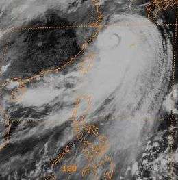
 Typhoon Agnes near peak intensity on August 31 | |
| Formed | August 25, 1981 |
| Dissipated | September 6, 1981 |
| (Extratropical after September 3) | |
| Highest winds | 10-minute sustained: 150 km/h (90 mph) 1-minute sustained: 175 km/h (110 mph) |
| Lowest pressure | 947 hPa (mbar); 27.96 inHg (Estimated at 950 mbar (hPa; 28.05 inHg) by the JMA) |
| Fatalities | 159 (killed or missing) |
| Damage | At least $135 million (1981 USD) |
| Areas affected | |
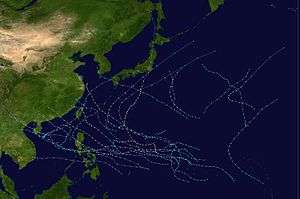
| Part of the 1981 Pacific typhoon season | |
Throughout the course of Agnes' existence, several countries were affected by torrential rains and typhoon-force winds. Hardest hit was South Korea where record-breaking rains triggered widespread flooding. More than 12,000 structures were damaged or destroyed by the storm and 191,000 acres (77,300 hectares) of farmland was inundated. A total of 113 people lost their lives in the country while damage reached $134 million. Taiwan saw similarly destructive rains which left 32 people dead or missing. A further 14 lives were lost in mainland China where coastal flooding from the typhoon's slow movement coincided with the spring tide, resulting in the greatest storm surge since 1949 along the Yangtze estuary and Hangzhou Bay. Much of Japan saw rains from the storm, though no significant damage or loss of life took place in the country.
Meteorological history

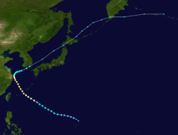
On August 23, 1981, following several days of tranquil weather, a Tropical Upper Tropospheric Trough (TUTT) began building westward from the International Dateline, near Wake Island. Over the following 36 hours, an expansive area of convection developed southwest of the organizing TUTT. On August 25, surface observations on Guam in the Mariana Islands indicated the presence of a low pressure system.[1] Coinciding with this, the Japan Meteorological Agency (JMA) declared the formation of a tropical depression at 06:00 UTC.[2] Weather reconnaissance missions throughout the day indicated a 1006 mbar (hPa; 29.71 inHg) center west of Guam, prompting the Joint Typhoon Warning Center (JTWC) to issue a Tropical Cyclone Formation Alert. Following improvement in the convective structure, the JTWC began warning on the cyclone as Tropical Depression 18W at 18:00 UTC, at which time the depression was situated roughly 665 km (415 mi) west-northwest of Guam.[1]
Tracking west-northwest and later northwest around the southwestern edge of a subtropical ridge, steady intensification of the cyclone ensued. Early on August 27, a reconnaissance plane measured a central pressure of 994 mbar (hPa; 29.36 inHg) and flight-level winds of 85 km/h (53 mph), indicating the system had become a tropical storm.[nb 2] In light of this, the JTWC assigned the name Agnes to the storm.[1][nb 3] Additionally due to its proximity to the Philippines, the Philippine Atmospheric, Geophysical and Astronomical Services Administration dubbed the system with the local name Pining.[3] Strengthening occurred at a climatological rate, with Agnes attaining typhoon-status on August 29. A large, banding eye-feature developed within the core of Agnes as it approached the Ryukyu Islands of southwestern Japan. The storm passed 170 km (105 mi) south of Okinawa around 06:00 UTC on August 30 and emerged over the East China Sea. Early on August 31, Agnes achieved its peak strength with winds of 175 km/h (110 mph) and an estimated central pressure of 947 mbar (hPa; 27.96 inHg). This ranked it as a Category 2-equivalent on the Saffir–Simpson hurricane wind scale.[1] The JMA estimated the system to have been slightly weaker, with ten-minute sustained winds of 150 km/h (90 mph) and a pressure of 950 mbar (hPa; 28.05 inHg).[2]
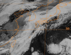
As the storm moved over the East China Sea on September 1, Agnes began to interact with a mid-latitude trough situated south of South Korea and began a prolonged extratropical transition. Increasing wind shear exposed the center of the typhoon and displaced convection to the north and east. Subsequent slowing of the cyclone's forward speed as it turned northward resulted in an extended period of heavy rain for much of South Korea. The JTWC estimated Agnes to have become predominantly extratropical by the end of September 1, coinciding with the system weakening below typhoon intensity.[1] The JMA, however, maintained the storm as a tropical system as it began moving northwest. The diminishing cyclone moved over the Korea Strait on September 3 and completed its extratropical transition that afternoon. Accelerating over the Sea of Japan, the remnant storm deepened slightly before striking the northern Japanese island of Hokkaido on September 4 with an estimated pressure of 976 mbar (hPa; 28.82 inHg). After moving over the Sea of Okhotsk, Agnes impacted the Kamchatka Peninsula of Russia on September 5. The system then moved over the open waters of the North Pacific and was last noted near the International Dateline on September 6.[2]
Impact
Japan
| Country | Dead/Missing | Total damages | ||||||
|---|---|---|---|---|---|---|---|---|
| China | 14 | >$1 million | ||||||
| Japan | 0 | N/A | ||||||
| South Korea | 113 | $134 million | ||||||
| Taiwan | 32 | N/A | ||||||
| Sources cited in text. | ||||||||
On August 30, Typhoon Agnes moved through the southern Ryukyu Islands, bringing strong winds and heavy rain to the region. Several islands received more than 200 mm (7.9 in) of rain, and a peak value of 304 mm (12.0 in) was measured on Ishigaki Island.[4] Despite passing through as a typhoon, only Tokashiki received winds of such intensity with a peak gust of 122 km/h (76 mph). A few other islands reported winds greater than 90 km/h (56 mph).[5]
After moving over the Sea of Japan, the storm's remnants brought heavy rains to much of Japan the day after a 6.6 Mw earthquake rocked eastern parts of the country. Air and sea transportation across the Korean Strait was cancelled for September 3. Landslides were reported across Kyushu, though no casualties occurred.[6] On Shin-Kamigotō, Nagasaki, rain fell at rates of 69 mm (2.7 in) per hour on September 3 as Agnes passed to the north.[7] Rainfall in the mainland peaked at 208 mm (8.2 in) on Chausuyama in Aichi Prefecture.[4]
China and Taiwan
Though Agnes did not directly impact Taiwan, prolonged southwesterly flow associated with the typhoon brought torrential rains to the island.[8] Flooding in southern Taiwan was considered the worst in 30 years; 32 people were killed or left missing.[9] More than 510 mm (20 in) of rain fell in the cities of Chiayi, Tainan, Kaohsiung, and Pingtung. Flood waters, reaching depths of 2.0 m (6.6 ft), inundated 238,256 acres (96,419 hectares) of farmland and destroyed 140 homes. An estimated 3,000 people were left homeless.[10]

Significant water rise occurred along Yangtze estuary and Hangzhou Bay in mainland China as Agnes remained just east of the area for 36 hours and the coincidence of the spring tide. A peak storm surge of 1.6 m (5.2 ft) was measured in the region with continuous onshore flow,[11] the highest since 1949;[9] conversely, in areas with continuous offshore flow, water levels fell by 20 cm (7.9 in). Model simulations of the event estimated that a 1.5 m (4.9 ft) surge affected the Waigaoqiao Free Trade Zone in Shanghai.[11] Offshore, 300 vessels sank while the resulting inland floods killed 14 people.[9] Authorities in Shanghai mobilized 100,000 personnel to limit the extent of the floods as 200 sections of seawall collapsed. According to local newspapers, 59,700 acres (24,100 hectares) of farmland flooded and 4,280 homes were damaged. Losses were estimated in the millions of dollars.[12]
High winds downed many trees across the region and debris littered the streets of Shanghai. United States President Jimmy Carter, wrapping up an inspection of the Chinese Navy, was scheduled to take a cruise out of the Huangpu River; however, the typhoon forced the vessel to remain at port.[13]
South Korea
Between September 1 and 3, torrential rains affected much of South Korea, with the heaviest falling well-ahead of the storm itself. Regarded as the heaviest on record in the 20th century, at least 710 mm (28 in) fell over a two-day span in the country, resulting in tremendous flash flooding and landslides.[1] This surpassed the previous two-day record of 570 mm (22.3 in) measured in 1928 in Seoul.[14] A record-breaking 24‑hour rainfall of 547.4 mm (21.55 in) was also measured; however, this was later greatly surpassed by Typhoon Rusa in 2002 which produced 870.5 mm (34.27 in) during the same time span.[15] The coastal counties of Jangheung, Haenam, and Goheung all saw approximately half of their annual precipitation, between 394 and 548 mm (15.5 and 21.6 in), in one day's time.[16] In addition to the rains, winds up to 144 km/h (89 mph) were measured.[14]
Communications with severed with towns along the southwestern coastline as roads and rail lines were washed away.[17] Thousands of residents sought refuge by moving to higher ground.[18] The Korean relief center reported that 762 homes were destroyed and another 11,700 flooded due to the storm.[19] Other reports indicated that upwards of 5,900 homes were destroyed.[18] More than 191,000 acres (77,300 hectares) of farmland was washed out.[6] Throughout South Korea, 113 people lost their lives.[20] Most of the deaths resulted from landslides, swollen rivers, and collapsed embankments.[14] Total damage in the country amounted to $134 million, with agriculture accounting for at least $24 million.[6][20] Additionally, 28,000 people were left homeless.[14] The disaster relief agency Hope Bridge provided 7.5 billion won ($10.2 million) in aid to areas affected by the storm.[21]
See also
- 1981 Pacific typhoon season
- Typhoon Maemi – The strongest recorded typhoon to strike South Korea
- List of wettest tropical cyclones by country
- Typhoon Rusa – Surpassed Agnes as the wettest tropical cyclone in South Korea in 2002
- Tropical Storm Nakri (2014) – The wettest-known tropical cyclone in South Korea as of 2014
Notes
References
- LTJG Robert C. Weir (1982). "Typhoon Agnes (18)". Annual Tropical Cyclone Report (PDF). Joint Typhoon Warning Center (Report). United States Navy. pp. 70–73. Retrieved September 15, 2014.
- Japan Meteorological Agency (2014). "Typhoon 198118 (Agnes) - Detailed Track Information". Digital Typhoon. National Institute of Informatics. Retrieved September 15, 2014.
- Michael V. Padua (June 11, 2008). PAGASA Tropical Cyclones 1963-1988 [within the Philippine Area of Responsibility (PAR)] (TXT) (Report). Typhoon 2000. Retrieved September 16, 2014.
- "Precipitation Summary". Digital Typhoon. National Institute of Informatics. 2014. Retrieved July 8, 2014.
- "Maximum Wind Summary". Digital Typhoon. National Institute of Informatics. 2014. Retrieved July 8, 2014.
- "Typhoon Agnes lashes Japan in wake of major quakes". The Globe and Mail. Tokyo, Japan. Reuters. September 4, 1981. – via Lexis Nexis (subscription required)
- "Precipitation Summary, Hourly Rain". Digital Typhoon. National Institute of Informatics. 2014. Retrieved July 8, 2014.
- K. K. W. Cheung; L.-R. Huang & C.-S. Lee (2008). "Characteristics of rainfall during tropical cyclone periods in Taiwan" (PDF). Natural Hazards and Earth System Sciences. 8 (6): 1, 463–1, 474. doi:10.5194/nhess-8-1463-2008. Retrieved September 15, 2014.
- "Part III – Tropical Cyclone Summaries". Meteorological Results 1981 (PDF) (Report). Hong Kong Observatory. 1982. p. 9. Retrieved July 8, 2014.
- "Taiwan's worst flooding in 30 years...". Taipei, Taiwan. Associated Press. September 5, 1981. – via Lexis Nexis (subscription required)
- K. Hu; P. Ding & J. Ge (2007). "Modeling of storm surge in the coastal waters of Yangtze Estuary and Hangzhou Bay, China" (PDF). Journal of Coastal Research (50): 961–965.
- Paul Shin (September 3, 1981). "Typhoon Agnes moved out into the Sea of Japan...". Seoul, South Korea. United Press International. – via Lexis Nexis (subscription required)
- "Carter inspects Chinese navy". Shanghai, China. United Press International. August 31, 1981. – via Lexis Nexis (subscription required)
- "Typhoon Agnes Lashes S. Korea". The Straits Times. United Press International. September 4, 1981. p. 8. Retrieved July 8, 2014.
- Ki-Ho Chang (2012). "Record of Typhoons" (PDF). Recent Activities of National Typhoon Center. National Typhoon Center. Korea Meteorological Agency. p. 11. Retrieved July 8, 2014.
- Jeon-Soo Park; Hyun-Sook Jung; Rae-Seon Kim & Jai-Ho Oh (2001). "Modelling Summer Extreme Rainfall Over the Korean Peninsula Using Wakeby Distribution". International Journal of Climatology. 21 (11): 1, 371–1384. Bibcode:2001IJCli..21.1371P. doi:10.1002/joc.701.
- "Flooding in S. Korea". Logansport Pharos-Tribune. Seoul, South Korea. United Press International. September 3, 1981. p. 2. Retrieved July 8, 2014. – via Newspapers.com (subscription required)
- "Heaviest rains of century in Korea". Seoul, South Korea. United Press International. September 3, 1981. – via Lexis Nexis (subscription required)
- "Death Toll From Storm Rises". Seoul, South Korea. Associated Press. September 3, 1981. – via Lexis Nexis (subscription required)
- Disaster History: Significant Data on Major Disasters Worldwide, 1900-Present (PDF) (Report). Washington D.C., United States: United States Agency for International Development. August 1993. p. 123. Retrieved October 8, 2014.
- "History". Hope Bridge. 2014. Retrieved July 8, 2014.
