Tropical Storm Higos (2008)
Tropical Storm Higos, known in the Philippines as Tropical Storm Pablo, was a tropical storm during the 2008 Pacific typhoon season. The name "Higos" is the Chamorro word for fig.[1]
| Tropical storm (JMA scale) | |
|---|---|
| Tropical storm (SSHWS) | |
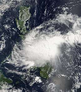 Higos near landfall in Samar on September 30 | |
| Formed | September 29, 2008 |
| Dissipated | October 6, 2008 |
| Highest winds | 10-minute sustained: 65 km/h (40 mph) 1-minute sustained: 75 km/h (45 mph) |
| Lowest pressure | 998 hPa (mbar); 29.47 inHg |
| Fatalities | Unknown |
| Damage | $6.5 million (2008 USD) |
| Areas affected | Philippines, China |
| Part of the 2008 Pacific typhoon season | |
Meteorological history
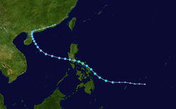
At 18:00 UTC on September 28, the Japan Meteorological Agency (JMA) assessed the formation of a tropical depression near Palau.[2] At 06:00 UTC the next day, the Joint Typhoon Warning Center (JTWC) issued a Tropical Cyclone Formation Alert on the westwardly tracking disturbance, designating it as Tropical Depression 21W.[3] Upon development, the storm showed signs of improving organization.[4] Consolidation continued as the storm approached the Philippines at the eve of October, though intensification was tempered by increasing wind shear and interaction with the archipelago.[5] On September 29, the storm entered the area of responsibility of the Philippine Atmospheric, Geophysical and Astronomical Services Administration (PAGASA), who locally named the system Pablo.[6] The tropical cyclone grazed eastern Samar and tracked towards southern Luzon—with the JMA noting little change in strength—on September 30, guided by a nearby subtropical ridge.[2][7] As the storm moved across the Philippines, its center of circulation became elongated and difficult to locate,[8] though deep convective activity initiated near the center as the storm began to accelerate into the South China Sea on October 1.[9] The JMA upgraded the cyclone to a minimal tropical storm by October 2 with sustained winds of 40 mph (65 km/h) and a minimum pressure of 996 mbar (hPa; 29.47 inHg); Higos would not strengthen further throughout its evolution in the South China Sea.[2] With the upgrade, the system was named Higos.[10] In contrast, the JTWC noted that the system had become disorganized in the same timeframe with a lack of consolidation noted in microwave satellite imagery.[11] Higos remained ill-defined the next day and was consequently downgraded to a tropical depression by the JMA.[2][12] On October 4, the weakening system crossed eastern Hainan and slowed considerably, with land interaction and wind shear creating hostile environmental conditions for Higos.[13] Higos drifted northeastward into mainland China as a tropical depression and eventually dissipated early on October 6.[2]
Preparations, warnings and impact
Preparations
Ferry services on Qiongzhou Strait in south China were suspended and authorities in two airports in Hainan Province: Meilan International Airport in Haikou, the provincial capital, and Fenghuang (Phoenix) International Airport in Sanya, a seaside resort on the southern tip of the island, managed to keep arrivals and departures at their respective airports going.
Warnings
Philippines
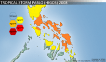
| Signal No. | Luzon | Visayas | Mindanao |
|---|---|---|---|
| PSWS #2 | Metro Manila, Rizal, Batangas, Cavite, Laguna, Quezon, Polilio Is., Marinduque, Northern Mindoro Oriental, Masbate, Camarines Provinces, Albay, Sorsogon, Catanduanes | Biliran, Samar Provinces, Leyte | None |
| PSWS #1 | Pangasinan, Nueva Ecija, Nueva Vizcaya, Quirino, Aurora, Bulacan, Bataan, Zambales, Pampanga, Tarlac, Lubang Is. Rest of Mindoro Oriental, Mindoro Occidental, Romblon | Aklan, Capiz, Northern Iloilo, Northern Negros Occidental, Northern Cebu. Southern Leyte | Dinagat Island, Surigao del Norte, Siargao Is. |
China
China issued an orange alert on for Higos and the State Flood Control and Drought Relief Headquarters activated a third degree emergency response on Friday to prevent flooding,[14] while in Hong Kong, the Standby Signal No. 1 was issued at 7.30 p.m. on October 2 when Higos was about 700 km south of Hong Kong. All tropical cyclone warning signals were cancelled at 10.30 p.m. on October 4 as Higos made landfall over western Guangdong and weakened.[15]
Impact
In Hong Kong, a sheet of glass fell off from a shopping centre in Tsim Sha Tsui when the Strong Monsoon Signal was in force. Two vehicles were damaged and a person was slightly injured during the incident. In addition, a scaffolding was reported loose in Kowloon Bay.[16] Higos caused $6.5 million in damage to the province of Xinhua, however its heavy rainfall may have stopped a potential drought from starting.[17]
See also
- Typhoon Mujigae
- Tropical Storm Rumbia (2013)
- Typhoon Sarika (2016)
References
- http://www.jma.go.jp/jma/jma-eng/jma-center/rsmc-hp-pub-eg/tyname.html#Column%20III
- Japan Meteorological Agency (2019). "1951-2019". RSMC Best Track Data (Text). Otemachi, Chiyoda-ku, Tokyo, Japan: Japan Meteorological Agency. Retrieved June 21, 2019.
- Joint Typhoon Warning Center (September 29, 2008). Tropical Depression 21W (Twentyone) Warning NR 001 (Tropical Cyclone Formation Alert). Pearl Harbor, Hawaii: Iowa State University.
- Satellite Products and Services Division (September 29, 2008). WWPN20 KNES 290941 (Tropical Bulletin). Washington, D.C.: Iowa State University.
- Joint Typhoon Warning Center (September 30, 2008). Prognostic Reasoning for Tropical Storm 21W Warning NR 004 (Prognostic Reasoning). Pearl Harbor, Hawaii: Iowa State University.
- Government of the Philippines (October 3, 2008). Philippines: NDCC update Sitrep No 3 re effects of Tropical Storm Pablo (Report). Manila, The Philippines: ReliefWeb. Retrieved June 21, 2019.
- Joint Typhoon Warning Center (September 30, 2008). Prognostic Reasoning for Tropical Storm 21W Warning NR 006 (Prognostic Reasoning). Pearl Harbor, Hawaii: Iowa State University.
- Joint Typhoon Warning Center (October 1, 2008). Prognostic Reasoning for Tropical Storm 21W Warning NR 008 (Prognostic Reasoning). Pearl Harbor, Hawaii: Iowa State University.
- Joint Typhoon Warning Center (October 1, 2008). Prognostic Reasoning for Tropical Storm 21W Warning NR 010 (Prognostic Reasoning). Pearl Harbor, Hawaii: Iowa State University.
- Gale Warning (Report). Otemachi, Chiyoda-ku, Tokyo, Japan: Iowa State University. October 1, 2008.
- Joint Typhoon Warning Center (October 2, 2008). Prognostic Reasoning for Tropical Depression 21W Warning NR 012 (Prognostic Reasoning). Pearl Harbor, Hawaii: Iowa State University.
- Joint Typhoon Warning Center (October 2, 2008). Prognostic Reasoning for Tropical Depression 21W Warning NR 016 (Prognostic Reasoning). Pearl Harbor, Hawaii: Iowa State University.
- Joint Typhoon Warning Center (October 4, 2008). Prognostic Reasoning for Tropical Depression 21W Warning NR 020 (Prognostic Reasoning). Pearl Harbor, Hawaii: Iowa State University.
- http://www.chinadaily.com.cn/china/2008-10/03/content_7075779.htm
- http://www.hko.gov.hk/informtc/higos/report.htm
- http://www.hko.gov.hk/informtc/higos/report.htm
- http://www.uclick.com/widgets/ew/081010/ew081010e.html
External links
| Wikimedia Commons has media related to Tropical Storm Higos (2008). |
- JMA General Information of Tropical Storm Higos (0817) from Digital Typhoon
- JMA Best Track Data of Tropical Storm Higos (0817) (in Japanese)
- JTWC Best Track Data of Tropical Storm 21W (Higos)
- 21W.HIGOS from the U.S. Naval Research Laboratory
Tropical cyclones of the 2008 Pacific typhoon season | ||||||||||||||||||||||||||||||||||||||||||||||||||||||||||||||||||||||||||||||||||
|---|---|---|---|---|---|---|---|---|---|---|---|---|---|---|---|---|---|---|---|---|---|---|---|---|---|---|---|---|---|---|---|---|---|---|---|---|---|---|---|---|---|---|---|---|---|---|---|---|---|---|---|---|---|---|---|---|---|---|---|---|---|---|---|---|---|---|---|---|---|---|---|---|---|---|---|---|---|---|---|---|---|---|
 |
| |||||||||||||||||||||||||||||||||||||||||||||||||||||||||||||||||||||||||||||||||
| ||||||||||||||||||||||||||||||||||||||||||||||||||||||||||||||||||||||||||||||||||