Tipton, Kansas
Tipton is a city in Mitchell County, Kansas, United States. As of the 2010 census, the city population was 210.[6]
Tipton, Kansas | |
|---|---|
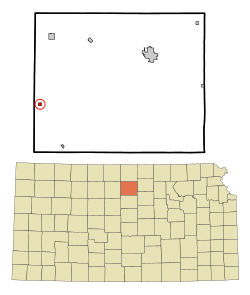 Location within Mitchell County and Kansas | |
 KDOT map of Mitchell County (legend) | |
| Coordinates: 39°20′22″N 98°28′13″W | |
| Country | United States |
| State | Kansas |
| County | Mitchell |
| Founded | 1872 |
| Incorporated | 1916 |
| Named for | Tipton, Iowa |
| Area | |
| • Total | 0.25 sq mi (0.65 km2) |
| • Land | 0.25 sq mi (0.65 km2) |
| • Water | 0.00 sq mi (0.00 km2) |
| Elevation | 1,604 ft (489 m) |
| Population | |
| • Total | 210 |
| • Estimate (2019)[3] | 193 |
| • Density | 765.87/sq mi (295.42/km2) |
| Time zone | UTC-6 (CST) |
| • Summer (DST) | UTC-5 (CDT) |
| ZIP code | 67485 |
| Area code | 785 |
| FIPS code | 20-70675 [4] |
| GNIS ID | 0472408 [5] |
| Website | tiptonkansas.com |
History
Tipton was originally called Pittsburg, and under the latter name was founded in 1872.[7] When it was later realized that another Pittsburg existed in Kansas, the name was changed to Tipton after Tipton, Iowa, the former home of a local resident.[8]
Geography
Tipton is located at 39°20′22″N 98°28′13″W (39.339380, -98.470155).[9] According to the United States Census Bureau, the city has a total area of 0.26 square miles (0.67 km2), all of it land.[10]
Demographics
| Historical population | |||
|---|---|---|---|
| Census | Pop. | %± | |
| 1920 | 230 | — | |
| 1930 | 294 | 27.8% | |
| 1940 | 248 | −15.6% | |
| 1950 | 246 | −0.8% | |
| 1960 | 252 | 2.4% | |
| 1970 | 315 | 25.0% | |
| 1980 | 321 | 1.9% | |
| 1990 | 267 | −16.8% | |
| 2000 | 243 | −9.0% | |
| 2010 | 210 | −13.6% | |
| Est. 2019 | 193 | [3] | −8.1% |
| U.S. Decennial Census | |||
2010 census
As of the census[2] of 2010, there were 210 people, 98 households, and 57 families residing in the city. The population density was 807.7 inhabitants per square mile (311.9/km2). There were 116 housing units at an average density of 446.2 per square mile (172.3/km2). The racial makeup of the city was 98.1% White and 1.9% Asian.
There were 98 households of which 21.4% had children under the age of 18 living with them, 53.1% were married couples living together, 1.0% had a female householder with no husband present, 4.1% had a male householder with no wife present, and 41.8% were non-families. 40.8% of all households were made up of individuals and 16.3% had someone living alone who was 65 years of age or older. The average household size was 2.14 and the average family size was 2.88.
The median age in the city was 47 years. 24.8% of residents were under the age of 18; 3.3% were between the ages of 18 and 24; 18.6% were from 25 to 44; 29% were from 45 to 64; and 24.3% were 65 years of age or older. The gender makeup of the city was 54.8% male and 45.2% female.
2000 census
As of the census[4] of 2000, there were 243 people, 108 households, and 69 families residing in the city. The population density was 959.5 people per square mile (375.3/km2). There were 118 housing units at an average density of 465.9 per square mile (182.2/km2). The racial makeup of the city was 99.59% White, 0.41% from other races. Hispanic or Latino of any race were 0.41% of the population.
There were 108 households out of which 27.8% had children under the age of 18 living with them, 58.3% were married couples living together, 4.6% had a female householder with no husband present, and 36.1% were non-families. 34.3% of all households were made up of individuals and 20.4% had someone living alone who was 65 years of age or older. The average household size was 2.25 and the average family size was 2.91.
In the city, the population was spread out with 23.0% under the age of 18, 3.3% from 18 to 24, 21.8% from 25 to 44, 25.9% from 45 to 64, and 25.9% who were 65 years of age or older. The median age was 46 years. For every 100 females, there were 92.9 males. For every 100 females age 18 and over, there were 101.1 males.
The median income for a household in the city was $33,750, and the median income for a family was $45,938. Males had a median income of $30,500 versus $14,375 for females. The per capita income for the city was $17,637. About 7.6% of families and 11.4% of the population were below the poverty line, including 14.8% of those under the age of eighteen and 12.8% of those sixty five or over.
Education
Waconda USD 272 serves the community. It operates two schools: Lakeside Elementary School in Cawker City and Lakeside High School in Downs.
Previously it operated Tipton Elementary School and Tipton Junior High School.[11]
Tipton Catholic High School is located in the community.
See also
- Meades Ranch Triangulation Station, the geodetic base point for the North American Datum of 1927 (NAD 27), which was used as a reference point until 1989.
- Waconda Lake and Glen Elder State Park.
References
- "2019 U.S. Gazetteer Files". United States Census Bureau. Retrieved July 24, 2020.
- "U.S. Census website". United States Census Bureau. Retrieved 2012-07-06.
- "Population and Housing Unit Estimates". United States Census Bureau. May 24, 2020. Retrieved May 27, 2020.
- "U.S. Census website". United States Census Bureau. Retrieved 2008-01-31.
- "US Board on Geographic Names". United States Geological Survey. 2007-10-25. Retrieved 2008-01-31.
- "2010 City Population and Housing Occupancy Status". U.S. Census Bureau. Retrieved June 19, 2011.
- Blackmar, Frank Wilson (1912). Kansas: A Cyclopedia of State History, Volume 2. Standard Publishing Company. pp. 808.
- "Histories of Mitchell County Towns". Blue Skyways. Kansas State Library. 1954. Archived from the original on 7 November 2013. Retrieved 15 June 2014.
- "US Gazetteer files: 2010, 2000, and 1990". United States Census Bureau. 2011-02-12. Retrieved 2011-04-23.
- "US Gazetteer files 2010". United States Census Bureau. Archived from the original on 2012-01-25. Retrieved 2012-07-06.
- Home. Waconda USD 272. April 9, 2002. Retrieved on February 25, 2017.
Further reading
External links
- City
- Historical
- Growing A Small Town on YouTube, from Hatteberg's People on KAKE TV news
- Maps
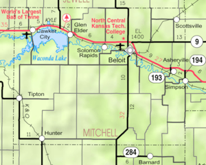
- Mitchell County Map, KDOT
Municipalities and communities of Mitchell County, Kansas, United States | ||
|---|---|---|
| Cities | 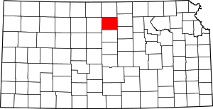 Map of Kansas highlighting Mitchell County | |
| CDP | ||
| Unincorporated community | ||
| Ghost towns | ||
| Townships |
| |
| Footnotes | ‡This populated place also has portions in an adjacent county or counties | |