Tinkers Creek Aqueduct
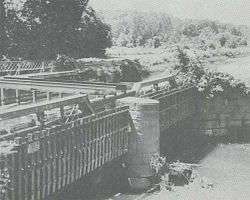
Tinkers Creek Aqueduct is an aqueduct that was constructed to bridge the Ohio and Erie Canal over Tinkers Creek near its confluence with the Cuyahoga River in Valley View, Ohio. It is a relatively rare surviving example of an Ohio and Erie Canal aqueduct. It was originally constructed in 1825-1827 by, and re-built due to flood damage in 1845 and 1905.[11] Tinkers Creek Aqueduct was included in a National Historic Landmark district established in 1966, and it was separately listed on the National Register of Historic Places in 1979.[12][13] The original Tinkers Creek Aqueduct was a wood plank, steel truss, and Ashlar-sandstone structure constructed in 1827, south of the present aqueduct's location. Cuyahoga River and Tinkers Creek flooding caused continual damage to the original aqueduct, so successive structures were built in 1845 and 1905 in the present location. Today, Tinkers Creek Aqueduct is the only aqueduct which remains of the four original aqueducts in the Cuyahoga Valley.[6] Of Furnace Run Aqueduct, Mill Creek Aqueduct, Peninsula Aqueduct, and (? Yellow Creek ?) Aqueduct; Mill Creek Aqueduct, of newer construction, is the only aqueduct which still carries Ohio and Erie Canal water. After 102 years of flooding, weathering, and deterioration, Tinkers Creek Aqueduct was removed in 2007. The National Park Service is currently working on Phase II of the project to reconstruct it from newer materials.[10]
Tinkers Creek Aqueduct | |
|---|---|
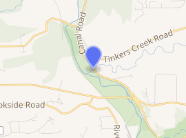
| Coordinates | 41°21′53.5″N 81°36′31.7″W Elevation: 610 feet (190 m)[1] |
| Carries | Ohio and Erie Canal |
| Crosses | Tinkers Creek (Cuyahoga River) |
| Locale | Canal Road and Tinkers Creek Road, Valley View, Cuyahoga County, Ohio |
| Maintained by | National Park Service, Cuyahoga Valley National Park |
| Characteristics | |
| Material | wood deck and sides, steel trusses over Ashlar-sandstone piers |
| Total length | Overall (including approaches): 90 feet (27 m)[2] Each span: about 40 feet (12 m)[3] |
| Width | Interior: 22 feet (6.7 m)[4] |
| No. of spans | 2 |
| Piers in water | 1 |
| Load limit | 16,500 pounds (7,500 kg) per running 1 foot (0.30 m)[4] |
| Clearance above | Unlimited[5] |
| Clearance below | 0 feet (0 m) |
| History | |
| Designer | [3] |
| Construction start | 1826 |
| Construction end | 1827 Re-built: 1845 and 1905[6] |
| Opened | 1827 until 1913 flood subsequent disuse 2007-? reconstruction project |
Tinkers Creek Aqueduct | |
U.S. National Historic Landmark District Contributing Property | |
 | |
| Location | Valley View, Cuyahoga County, Ohio |
| Area | less than one acre |
| Built | 1825-1827; rebuilt 1845 and 1905 |
| Part of | Ohio and Erie Canal (ID66000607) |
| MPS | Ohio and Erie Canal TR |
| NRHP reference No. | 79000296[9] |
| Significant dates | |
| Added to NRHP | December 11, 1979[9] |
| Designated NHLDCP | November 13, 1966[10] |

| |
Statistics
- Ohio and Erie Canal
- Valley View Village, County of Cuyahoga, Ohio
- Ohio 631
- Elevation: 610 feet (185.9 m)[1]
- National Register Number: 66000607
- Resource type: District.
- Property type: Transportation - water -related.
- The threat level was Threatened in 2006.
- Congressional District: OH-11
- Certified Local Government: NO
- This NHL offers public access.
- Current use/information: Part of Cuyahoga Valley National Park.[14]
Condition
The Tinkers Creek Aqueduct is a contributing structure on the NHL portion of the canal and continues to deteriorate rapidly. Due to the advanced state of decay, the aqueduct structure and the associated towpath Trial bridge will be removed and eventually replace with a newer aqueduct and bridge. Phase 1 of the project will involve removal of the existing aqueduct and Towpath Bridge, installation of a new Towpath Bridge, installation of temporary steel pipes to carry the canal water over the creek, restoration of portions of the sandstone abutment walls, and installation of a temporary high-water overflow structure. A later phase will include replacement of the aqueduct structure with a new design and restoration of the existing sandstone center pier and remaining abutment walls. Phase 1 is to begin in FY 2007. The increased numbers of flood events in recent years has caused significant damage to the river and stream banks which potentially threatens the canal basin. Ongoing monitoring and stabilization of river and stream banks will continue as needed.[14]
Flooding
The aqueduct and surrounding area are subject to flooding by the Cuyahoga River and Tinkers Creek.[15]
See also
- List of bridges documented by the Historic American Engineering Record in Ohio
- List of bridges on the National Register of Historic Places in Ohio
- List of Registered Historic Places in Cuyahoga County, Ohio
References
- U.S. Geological Survey Geographic Names Information System: Tinkers Creek Aqueduct
- "Towpath Trail bridge finished". Ohio.Com of Akron Beacon Journal.
- 1905 re-build engineers: C.E. Perkins, Columbus; T.D.P., Akron"Improvement of the Northern Division of the Ohio Canal (1905)". Cleveland Memory, Cleveland State University Libraries.
- "Tinkers Creek Aqueduct drawing" (JPG). Cleveland Memory, Cleveland State University Libraries.
- Tinkers Creek Aqueduct on the Ohio and Erie Canal has no overhead structural members, so has unlimited overhead clearance; elsewhere along the Ohio and Erie Canal, other overhead bridges, overhead power lines and trees limit vertical clearance.
- "Ohio & Erie Canal Towpath Trail Tour, Tinkers Creek Aqueduct". National Park Service, Cuyahoga Valley National Park. Archived from the original on June 3, 2008.
- "Historic Photograph of Tinkers Creek Aqueduct" (JPEG). National Park Service, Cuyahoga Valley National Park.
- "Cuyahoga Valley National Park figures". National Park Service, Cuyahoga Valley National Park.
- "National Register Information System". National Register of Historic Places. National Park Service. July 9, 2010.
- "Ohio and Erie Canal TR Tinkers Creek Aqueduct". National Historic Landmark summary listing. National Park Service, National Historic Landmarks Program. Archived from the original on 2008-06-19.
- "Tinkers Creek Aqueduct blueprints and photos". U.S. Library of Congress.
- "National Register of Historic Places". National Park Service, Cuyahoga Valley National Park.
- Mendinghall, Joseph S. (February 28, 1975). "National Register of Historic Places Inventory-Nomination: Ohio and Erie Canal" (pdf). National Park Service. Cite journal requires
|journal=(help) - "National Historic Landmark, Ohio and Erie Canal, Tinkers Creek Aqueduct". National Park Service. Archived from the original on 2008-06-19.
- "Flood Damage Images - Canal Damage". National Park Service.
External links
| Wikimedia Commons has media related to Tinkers Creek Aqueduct. |
- Historic American Engineering Record (HAER) No. OH-59-F, "Ohio & Erie Canal, Tinker's Creek Aqueduct, Canal Road, South Tinkers Creek Road, Valley View, Cuyahoga County, OH", 8 photos, 1 photo caption page
![]()