Timrå
Timrå (![]()
Timrå | |
|---|---|
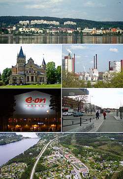 Timrå montage, Top:Panorama view of downtown Timrå, from Alnön area, 2nd left:A native house and museum in Merlo Slotto, 2nd right:A headquarters in Östrands pulp (Östrands massafabrik), 3rd left:Sydkraft Arena (E.ON Arena), 3rd right:Köpmansgatan Square, Bottom:Aerial view over Sörberge with Indalsälven left and Fairhaven in the upper right corner | |
 Timrå  Timrå | |
| Coordinates: 62°29′13″N 17°19′33″E | |
| Country | Sweden |
| Province | Medelpad |
| County | Västernorrland County |
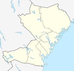
| Municipality | Timrå Municipality |
| Area | |
| • City | 12.03 km2 (4.64 sq mi) |
| • Metro | 787.98 km2 (304.24 sq mi) |
| Elevation | 19 m (62 ft) |
| Population (31 December 2010)[1] | |
| • City | 10,443 |
| • Density | 868/km2 (2,250/sq mi) |
| • Metro | 17,844 |
| Time zone | UTC+1 (CET) |
| • Summer (DST) | UTC+2 (CEST) |
| Postal code | 860 xx |
| Area code(s) | (+46) 60 |
| Website | www |
It is located about 13 km north of Sundsvall (a town with a metropolitan area of some 100,000 inhabitants), and could arguably be considered a satellite to that town.
The two closest cities (Sundsvall and Härnösand) share one airport, Midlanda, that is geographically located in Timrå.
Indalsälven, one of Sweden's largest rivers with a length of 430 km, meets the Gulf of Botnia in Timrå.
In Sweden, Timrå is mainly known for its ice hockey club Timrå IK, which, as of season 2018/19 plays in the Swedish top division SHL.
In 1995, Swedish artist Bengt Lindström constructed the Y, a 30 meter high sculpture located in Timrå.
Local legend says that Sörberge, on the north side of the town, is haunted by a tall man wearing a very large coat called 'Stor Bubbas'.
Climate
Timrå has historically had a subarctic climate, but it has in recent decades more resembled a cool-summer humid continental climate.
| Climate data for Sundsvall Airport near Timrå (2002-2015); extremes since 1943; precipitation 1961-1990 | |||||||||||||
|---|---|---|---|---|---|---|---|---|---|---|---|---|---|
| Month | Jan | Feb | Mar | Apr | May | Jun | Jul | Aug | Sep | Oct | Nov | Dec | Year |
| Record high °C (°F) | 11.0 (51.8) |
13.8 (56.8) |
15.2 (59.4) |
21.9 (71.4) |
27.4 (81.3) |
31.0 (87.8) |
33.0 (91.4) |
31.3 (88.3) |
27.2 (81.0) |
20.1 (68.2) |
14.0 (57.2) |
10.5 (50.9) |
33.0 (91.4) |
| Average high °C (°F) | −2.5 (27.5) |
−1.4 (29.5) |
3.2 (37.8) |
8.5 (47.3) |
13.9 (57.0) |
18.3 (64.9) |
21.5 (70.7) |
20.0 (68.0) |
15.4 (59.7) |
8.2 (46.8) |
2.5 (36.5) |
−0.8 (30.6) |
8.0 (46.4) |
| Daily mean °C (°F) | −6.6 (20.1) |
−5.8 (21.6) |
−1.5 (29.3) |
3.5 (38.3) |
8.6 (47.5) |
12.8 (55.0) |
16.6 (61.9) |
15.4 (59.7) |
10.7 (51.3) |
4.3 (39.7) |
−0.4 (31.3) |
−4.4 (24.1) |
4.4 (39.9) |
| Average low °C (°F) | −10.6 (12.9) |
−10.2 (13.6) |
−6.3 (20.7) |
−1.5 (29.3) |
3.3 (37.9) |
7.4 (45.3) |
11.8 (53.2) |
10.8 (51.4) |
6.0 (42.8) |
0.4 (32.7) |
−3.4 (25.9) |
−8.1 (17.4) |
0.0 (32.0) |
| Record low °C (°F) | −35.5 (−31.9) |
−34.8 (−30.6) |
−34.2 (−29.6) |
−20.0 (−4.0) |
−8.2 (17.2) |
−2.0 (28.4) |
1.9 (35.4) |
−0.6 (30.9) |
−7.7 (18.1) |
−15.2 (4.6) |
−22.1 (−7.8) |
−36.6 (−33.9) |
−36.6 (−33.9) |
| Average precipitation mm (inches) | 38.3 (1.51) |
28.1 (1.11) |
29.5 (1.16) |
31.9 (1.26) |
34.6 (1.36) |
40.7 (1.60) |
58.0 (2.28) |
64.1 (2.52) |
63.8 (2.51) |
51.8 (2.04) |
53.1 (2.09) |
46.1 (1.81) |
539.3 (21.23) |
| Source 1: SMHI precipitation average 1961-1990[2] | |||||||||||||
| Source 2: SMHI climate data 2002-2015[3] | |||||||||||||
Notable citizens
- Lennart "Lillstrimma" Svedberg (1944–1972), ice hockey player
- Magdalena Forsberg (1967), cross country skier, biathlon
- Henrik Flyman, guitarist, composer, producer
- Henrik Forsberg (1967), cross country skier
- Mats Näslund (1959), ice hockey player
Gallery
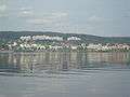 Timrå
Timrå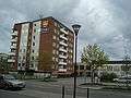 The municipal office
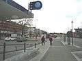 Town centre
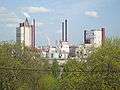 Östrand pulp mill
References
| Wikimedia Commons has media related to Timrå. |
- "Tätorternas landareal, folkmängd och invånare per km2 2005 och 2010" (in Swedish). Statistics Sweden. 14 December 2011. Archived from the original on 27 January 2012. Retrieved 10 January 2012.
- "SMHI precipitation average 1961-1990" (in Swedish). Swedish Metereological and Hydrological Institute (Sundsvalls flygplats code 12 731).
- "SMHI climate data 2002-2015" (in Swedish). SMHI. April 11, 2016.
External links
Municipalities and seats of Västernorrland County | ||
|---|---|---|
| Municipalities | ||
| Municipal seats | ||
| Authority control |
|
|---|