Tighvein
Tighvein is a hill above Lamlash on the Isle of Arran in western Scotland.[1] It is a Marilyn (a hill with topographic prominence of at least 150m) and the highest point on the south-eastern section of the island, south-east of the pass of Monambre Glen. Two miles from the nearest road, the top is a heathery, boggy moor, almost entirely ringed by thick forestry plantations. For this reason it is rarely climbed; there are no paths to the top.
| Tighvein | |
|---|---|
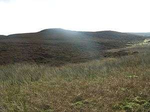 Tighvein from the north | |
| Highest point | |
| Elevation | 458 m (1,503 ft) |
| Prominence | 181 m (594 ft) |
| Parent peak | A' Chruach |
| Listing | Marilyn |
| Naming | |
| English translation | ??? |
| Language of name | Gaelic |
| Geography | |
| Location | Isle of Arran, Scotland |
| OS grid | NR997274 |
| Topo map | OS Landranger 69 |
Footnotes
- "Overview of Tighvein". Gazetteer for Scotland. Retrieved 2008-10-02.
| Main villages |  | |
|---|---|---|
| Smaller villages and settlements | ||
| Mountains and hills | ||
| History |
| |
| Environment |
| |
| Economy | ||
| Surrounding islands |
| |
gollark: There's a "STOP DOING MATH" one too, is this part of a series? Can I find *others* somewhere?
gollark: I play modded, so I don't have to bother with actually manually mining for very long.
gollark: Mining at night is completely sensible. The anti-night-mining thing is just ridiculous propaganda.
gollark: Well, I will add that to my queue of unwatched videos.
gollark: No.
This article is issued from Wikipedia. The text is licensed under Creative Commons - Attribution - Sharealike. Additional terms may apply for the media files.