Thunderbird Bay, Texas
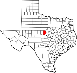
Thunderbird Bay is a census-designated place (CDP) in Brown County in central Texas, United States. The population was 663 at the 2010 census.[3]
Thunderbird Bay, Texas | |
|---|---|
 Thunderbird Bay | |
| Coordinates: 31°54′32″N 99°1′11″W | |
| Country | United States |
| State | Texas |
| County | Brown |
| Area | |
| • Total | 2.9 sq mi (7.6 km2) |
| • Land | 2.5 sq mi (6.6 km2) |
| • Water | 0.4 sq mi (1.0 km2) |
| Elevation | 1,460 ft (450 m) |
| Population (2010) | |
| • Total | 663 |
| • Density | 261/sq mi (100.7/km2) |
| Time zone | UTC-6 (Central (CST)) |
| • Summer (DST) | UTC-5 (CDT) |
| Area code(s) | 325 |
| FIPS code | 48-72902[1] |
| GNIS feature ID | 2586996[2] |
Geography
Thunderbird Bay is located in north-central Brown County along the northern arm of Lake Brownwood, a reservoir on Pecan Bayou. By road, the CDP is 20 miles (32 km) north of Brownwood, the county seat.
According to the United States Census Bureau, the CDP has a total area of 2.9 square miles (7.6 km2), of which 2.5 square miles (6.6 km2) is land and 0.39 square miles (1.0 km2), or 13.42%, is water.[3]
gollark: > I mean, I don't think that potatOS was a success<@170530017103577089> HERESY!
gollark: <@!222424031368970240> If you're trying to make a sandbox which can't be broken even if you know it's there and are deliberately trying to remove it here are some things to watch out for- `getfenv`- `os.queueEvent` (if you run code which does basically any IO outside of the sandbox/with access to non-sandbox functions)- `debug`- `load` (it has some weird environment quirks)- `io` (due to, again, environment weirdness, depending on how you load the new FS API it might still use the regular one)- potential meddling with global APIs like `string` and/or metatables, to confuse your sandboxing codeand to hide it you probably also want to worry about- `debug`- `string.dump`- `error` (you can generate stack tracebacks in a really convoluted way using it, which could allow detecting the sandbox)- `error` (in some very convoluted way you can generate stack tracebacks using this and thus realize
gollark: Proper sandboxing is extremely hard. But if you want to protect against people/things not actively attempting to break it you can do quite well.
gollark: What happened to make you want to avoid programming anyway?
gollark: I don't really care enough about replacing DokuWiki now to pay money for it.
References
- "U.S. Census website". United States Census Bureau. Retrieved 2008-01-31.
- "US Board on Geographic Names". United States Geological Survey. 2007-10-25. Retrieved 2008-01-31.
- "Geographic Identifiers: 2010 Demographic Profile Data (G001): Thunderbird Bay CDP, Texas". U.S. Census Bureau, American Factfinder. Archived from the original on February 12, 2020. Retrieved April 22, 2014.
This article is issued from Wikipedia. The text is licensed under Creative Commons - Attribution - Sharealike. Additional terms may apply for the media files.
