Thunder Lake (Alberta)
| Thunder Lake | |
|---|---|
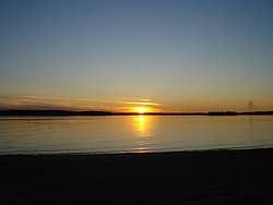
 Sunset at Thunder Lake | |
| Location | County of Barrhead No. 11, Alberta |
| Coordinates | 54°07′37″N 114°45′30″W |
| Basin countries | Canada |
| Max. length | 2.8 km (1.7 mi) |
| Max. width | 5.4 km (3.4 mi) |
| Surface area | 7.03 km2 (2.71 sq mi) |
| Average depth | 3.0 m (9.8 ft) |
| Max. depth | 6.1 m (20 ft) |
| Surface elevation | 656 m (2,152 ft) |
Description
The lake is located in northern Alberta, 25 kilometres (16 mi) west of Barrhead, immediately south of Tiger Lily, at an elevation of 656 m (2,152 ft).
It reaches a maximum depth of 6.1 m (20 ft), and is on average 3.0 m (9.8 ft) deep.[1]
Thunder Lake Provincial Park is established on the north-eastern shore of the lake, and the community of Thunder Lake on the southeastern shore.
gollark: He *is* explicitly saying he's not going to tell me, which is... problematic.
gollark: Great, so you're basically mildly evil.
gollark: I mean, I figure that with significant work people probably could uniquely identify me and/or get my location. If someone does that, they should NOTIFY ME OF IT and PROVIDE STEPS TO STOP THAT, not just sort of boast about it.
gollark: He is edgy™ and apparently does not listen to others' moral standards™.
gollark: Probably.
See also
- List of lakes in Alberta
This article is issued from Wikipedia. The text is licensed under Creative Commons - Attribution - Sharealike. Additional terms may apply for the media files.
