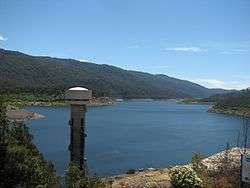
Thomson Dam
The Thomson Dam is a major earth and rockfill embankment dam with a controlled chute spillway across the Thomson River, located about 130 kilometres (81 mi) east of Melbourne in the West Gippsland region of the Australian state of Victoria. The impounded reservoir is officially called Thomson Reservoir, sometimes called Lake Thomson.
| Thomson Dam | |
|---|---|
 | |
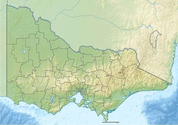 Location of the Thomson Dam in Victoria | |
| Country | Australia |
| Location | West Gippsland, Victoria |
| Coordinates | 37°50′34″S 146°23′56″E |
| Purpose | Water supply, irrigation |
| Status | Operational |
| Construction began | 1976 |
| Opening date | May 1983 |
| Owner(s) | Melbourne Water |
| Dam and spillways | |
| Type of dam | Embankment dam |
| Impounds | Thomson River |
| Height (foundation) | 166 m (545 ft) |
| Length | 590 m (1,940 ft) |
| Dam volume | 14,170×103 m3 (500×106 cu ft) |
| Spillways | 1 |
| Spillway type | Controlled chute |
| Spillway capacity | 1,040 m3/s (37,000 cu ft/s) |
| Reservoir | |
| Creates | Thomson Reservoir (official); called Lake Thomson |
| Total capacity | 1,123,090 ML (2.4705×10¹¹ imp gal; 2.9669×10¹¹ US gal) |
| Catchment area | 487 km2 (188 sq mi) |
| Surface area | 22.3 km2 (8.6 sq mi) |
| Normal elevation | 494 m (1,621 ft) AHD |
| Website Thomson Reservoir at Melbourne Water | |
Location and features
The dam is located near the former township of Beardmore and the Baw Baw National Park.
Despite opposition from conservationists and farmers, plans for the dam were originally approved in late December 1975 to provide Melbourne with water security. A dam on the Thomson River was preferred because the river had a large flow, high water quality and was elevated high enough to provide water to the upper Yarra system by gravity flow.[1]
Early work in the early 1970s saw construction of a 19 kilometres (12 mi) long tunnel through the Thomson Yarra divide to allow water from the Thomson River to flow into the Upper Yarra Reservoir. Work on the dam itself commenced in 1976 and the dam wall was ready to contain water by 1983.
The tunnel, which is located at the northern end of the reservoir, allows water to be transferred west to Upper Yarra Reservoir and then on to Silvan Reservoir for distribution as drinking water in Melbourne.
Hydroelectricity Generation
Downstream releases from Thomson Reservoir pass through a 7.4 MW[2] hydro power plant, at the base of the dam which generates electricity and feeds it into the state power grid.
Water supply levels
Between 1997 and 2011, drought depleted much of the reservoir's water. In early January 2006, the Thomson Dam was at 45.4%. While there were minor rises in water levels occasionally, the Thomson Dam reached its all-time low of 16.2% on 3 July 2009.[3]
Heavy rainfall in 2010 and 2011 has increased Melbourne's water storages to levels not seen for ten years.[4] The Thomson Dam entered winter 2011 at 39% full[5] and by the end of 2011 had reached 54.4% full.[6]
The last time the reservoir was full and spilling was in the spring of 1996.
The Thomson Dam is managed by Melbourne Water.[7]
References
- Pigram, John J. (2007). Australia's Water Resources: From use to management. Collingwood, Victoria: CSIRO Publishing. p. 94. ISBN 978-0-643-09442-0.
- http://www.ghd.com/global/projects/dam-powerful/
- Melbourne Water: Water Storage Levels Archive
- http://www.melbournewater.com.au/content/water_storages/water_report/weekly_water_report_archives.asp?year=2001&file=wrr010104.html
- http://www.melbournewater.com.au/content/water_storages/water_report/weekly_water_report_archives.asp?year=2011&file=wrr110603.html
- http://www.melbournewater.com.au/content/water_storages/water_report/weekly_water_report_archives.asp?year=2011&file=wrr111216.html
- Melbourne Water
External links
- Thomson Reservoir
- Fact Sheet
- Lowdown on the Thomson Reservoir - The Age, 5 June 2003
- Crunch time today for Thomson Dam - The Age, 13 December 2006
- 'Drought-proof' dam hits record low level