The Rock, Georgia
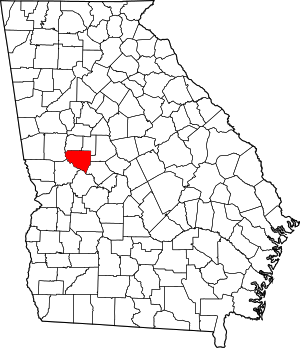
The Rock is an unincorporated community in Upson County, Georgia, United States. The Rock is located on Georgia State Route 36, 7 miles (11 km) northeast of Thomaston. The Rock has a post office with ZIP code 30285,[2] although the post office is on the list to be closed.[3] The Rock is home to the area-famous Rock Ranch, a small theme park with a farming theme.
The Rock, Georgia | |
|---|---|
Unincorporated community | |
 The Rock, Georgia | |
| Coordinates: 32°57′50″N 84°14′28″W | |
| Country | United States |
| State | Georgia |
| County | Upson |
| Elevation | 823 ft (251 m) |
| Time zone | UTC-5 (Eastern (EST)) |
| • Summer (DST) | UTC-4 (EDT) |
| ZIP code | 30285 |
| Area code(s) | 706 |
| GNIS feature ID | 333213[1] |
The Rock is bordered by the cities of Barnesville, Hannahs Mill, Meansville, and Yatesville.
History
A post office called The Rock was established in 1853.[4] The community was named for a rock formation near the original town site.[5]
The Georgia General Assembly incorporated The Rock as a town in 1877.[6] The town's municipal charter was repealed in 1995.[5]
gollark: ^^^
gollark: Er, I mean, `require` has odd path resolution.
gollark: Just with odd path resolution.
gollark: In any case, `loadfile` *is* basically the same.
gollark: Besides, they can add require easily with a small polyfill or whatever.
References
- "US Board on Geographic Names". United States Geological Survey. 2007-10-25. Retrieved 2008-01-31.
- ZIP Code Lookup
- http://about.usps.com/news/electronic-press-kits/expandedaccess/states/georgia.htm
- "Post Offices". Jim Forte Postal History. Retrieved 23 June 2019.
- Krakow, Kenneth K. (1975). Georgia Place-Names: Their History and Origins (PDF). Macon, GA: Winship Press. p. 224. ISBN 0-915430-00-2.
- Acts and Resolutions of the General Assembly. 1877. p. 189.
This article is issued from Wikipedia. The text is licensed under Creative Commons - Attribution - Sharealike. Additional terms may apply for the media files.
