The East Temple
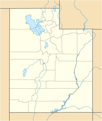
The East Temple[2] is a prominent 7,709 feet (2,350 m) summit made of Navajo Sandstone in Zion National Park in Washington County of Utah, United States. The nearest higher peak is The West Temple, 3.85 miles (6.20 km) to the west-southwest.[1] The mountain is situated 1.8 miles northeast of the park headquarters, at the confluence of Pine Creek and the North Fork Virgin River. It is one of the notable landmarks in the park.
| The East Temple | |
|---|---|
.jpg) The East Temple | |
| Highest point | |
| Elevation | 7,709 ft (2,350 m) [1] |
| Prominence | 1,709 ft (521 m) [1] |
| Coordinates | 37°13′14″N 112°57′03″W [1] |
| Geography | |
 The East Temple Location in Utah  The East Temple The East Temple (the United States) | |
| Location | Zion National Park Washington County, Utah United States |
| Parent range | Colorado Plateau |
| Topo map | USGS Springdale East |
| Geology | |
| Type of rock | Navajo sandstone |
| Climbing | |
| Easiest route | Climbing class 5.4 |
Climbing Routes
Climbing Routes on The East Temple[3]
- Casual Route - class 5.4 - 4 pitches
- Fang Spire - class 5.9 - 5 pitches
- Lovelace - class 5.10 - 9 pitches
- Cowboy Bob Goes to Zion - class 5.10 - 10 pitches
- Mobius - class 5.11 - 5 pitches
Gallery
.jpg) The East Temple under rainbow
The East Temple under rainbow.jpg) The East Temple
The East Temple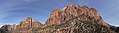 Mount Spry (left) with The East Temple (right)
gollark: You don't want that though.
gollark: HECf-251 oxide, I think.
gollark: The coffee stuff is nice, I have mine set up to effectively make somewhat reusable swiftness 4 potions.
gollark: It's nice to not be stuck in the same cuboid piping thingy.
gollark: The lasers are great.
See also
- List of Mountains in Utah
References
- "The East Temple, Utah". Peakbagger.com.
- U.S. Geological Survey Geographic Names Information System: The East Temple
- The East Temple Mountain Project
This article is issued from Wikipedia. The text is licensed under Creative Commons - Attribution - Sharealike. Additional terms may apply for the media files.