Texas State Highway 149
State Highway 149 (SH 149) is a state highway that runs from Carthage to Longview in east Texas.
| ||||
|---|---|---|---|---|
 | ||||
| Route information | ||||
| Maintained by TxDOT | ||||
| Length | 33.9 mi[1] (54.6 km) | |||
| Existed | 1930–present | |||
| Major junctions | ||||
| South end | ||||
| North end | ||||
| Location | ||||
| Counties | Panola, Rusk, Gregg | |||
| Highway system | ||||
| ||||

History
SH 149 was originally designated on March 19, 1930 along its current route, replacing SH 26A. On August 4, 1932, SH 149 was extended north to Daingerfield.[2] On June 25, 1935, everything north of Longview was cancelled (this section north of Longview was intended to be cancelled on August 15, 1933), but was restored on June 16, 1936.[3][4] The northern extension was transferred to SH 26 on September 26, 1939. On October 28, 1987, a loop around Carthage was completed, with SH 149 being routed around the western side of town along Loop 436. The old routing that entered Carthage was re-designated Spur 572. Loop 436 was cancelled on September 25, 1989 to remove concurrent mileage with SH 149.
Route description
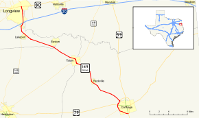
SH 149 begins at an intersection with US Route 259 and US Route 80 in downtown Longview. The route travels southward concurrent with US 259 to an intersection with Interstate 20. SH 149 and US 259 split here, with US 259 traveling west with I-20 and SH 149 continuing south. The route meets State Highway 322 near the East Texas Regional Airport before turning southeast. The routes continues, intersecting SH 43 at Tatum, before continuing on toward Carthage. At Carthage, the routes continues around the western portion of the loop around town, briefly running concurrent with US Route 79, before reaching its southern terminus at US Route 59 (Future Interstate 369) on the south side of town.
Major intersections
| County | Location | mi | km | Destinations | Notes |
|---|---|---|---|---|---|
| Panola | Carthage | Interchange; U.S. 59 is the future Interstate 369 | |||
| Interchange, south end of US 79 overlap | |||||
| | Interchange, north end of US 79 overlap | ||||
| | South end of FM 959 overlap | ||||
| | North end of FM 959 overlap | ||||
| Beckville | |||||
| Rusk | Tatum | ||||
| | |||||
| Gregg | | ||||
| | |||||
| Lakeport | South end of SH 322 overlap | ||||
| Longview | North end of SH 322 overlap | ||||
| Interchange, south end of US 259 overlap | |||||
| North end of US 259 overlap | |||||
| 1.000 mi = 1.609 km; 1.000 km = 0.621 mi | |||||
References
- Transportation Planning and Programming Division (n.d.). "State Highway No. 149". Highway Designation Files. Texas Department of Transportation. Retrieved 2010-11-01.
- (PDF) https://publicdocs.txdot.gov/minord/MinuteOrderDocLib/003673820.pdf. Missing or empty
|title=(help) - (PDF) https://publicdocs.txdot.gov/minord/MinuteOrderDocLib/003673870.pdf. Missing or empty
|title=(help) - (PDF) https://publicdocs.txdot.gov/minord/MinuteOrderDocLib/003673885.pdf. Missing or empty
|title=(help)