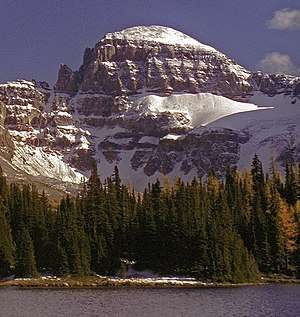
Terrapin Mountain
Terrapin Mountain is located on the border of Alberta and British Columbia on the Continental Divide. It was named in 1918.[1][2] A ridge extending north from the mountain terminates at Naiset Point.
| Terrapin Mountain | |
|---|---|
 | |
| Highest point | |
| Elevation | 2,954 m (9,692 ft) [1] |
| Prominence | 235 m (771 ft) |
| Coordinates | 50°52′48″N 115°37′06″W |
| Geography | |
 Terrapin Mountain Location in Alberta and British Columbia | |
| Location | Alberta British Columbia |
| Topo map | NTS 82J/13 |
| Climbing | |
| First ascent | 1915 H.O. Frind, L. Jeffers, Conrad Kain |
Climate
Based on the Köppen climate classification, Terrapin Mountain is located in a subarctic climate with cold, snowy winters, and mild summers.[3] Temperatures can drop below −20 °C with wind chill factors below −30 °C.
gollark: BUT those things would incur a bunch of cost - either financial or time - and I don't need high uptime enough to pay that.
gollark: As an example, osmarks.tk isn't up all the time. This is probably because it runs off my home internet connection and such, and partly because I do server migrations in ways which leave services down a bit. If I actually *needed* more than the current ~99% (okay I'm wildly guessing) uptime, there are many ways I could improve it.
gollark: You *want* 24/7 uptime, but trying to squeeze out increasingly high uptime means increasingly high costs.
gollark: Again, you brought up the "definition" first.
gollark: YOu brought it up first.
See also
- List of peaks on the British Columbia-Alberta border
- Mountains of Alberta
- Mountains of British Columbia
References
- PeakFinder
- Terrapin Mountain
- Peel, M. C.; Finlayson, B. L. & McMahon, T. A. (2007). "Updated world map of the Köppen−Geiger climate classification". Hydrol. Earth Syst. Sci. 11: 1633–1644. ISSN 1027-5606.
This article is issued from Wikipedia. The text is licensed under Creative Commons - Attribution - Sharealike. Additional terms may apply for the media files.