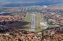
Teresina Airport
Teresina–Senador Petrônio Portella Airport (IATA: THE, ICAO: SBTE) is the airport serving Teresina, Brazil. Since December 22, 1999 it is named after Petrônio Portella Nunes (1925-1980) a former Mayor of Teresina, Governor of Piauí, Senator and Minister of Justice who had a key role in preparing the end of the Brazilian military government.[4]
Teresina–Senador Petrônio Portella Airport Aeroporto de Teresina–Senador Petrônio Portella | |||||||||||
|---|---|---|---|---|---|---|---|---|---|---|---|
 | |||||||||||
| Summary | |||||||||||
| Airport type | Public | ||||||||||
| Operator | Infraero | ||||||||||
| Serves | Teresina | ||||||||||
| Elevation AMSL | 67 m / 219 ft | ||||||||||
| Coordinates | 05°03′38″S 042°49′28″W | ||||||||||
| Website | www4 | ||||||||||
| Map | |||||||||||
 THE Location in Brazil | |||||||||||
| Runways | |||||||||||
| |||||||||||
| Statistics (2019) | |||||||||||
| |||||||||||
It is operated by Infraero.
History
The airport was opened on September 30, 1967 and since December 23, 1974 it is operated by Infraero.
The airport underwent major renovations between 1998 and 2001, including the passenger terminal, runway and the construction of a new control tower.
Airlines and destinations

Aerial view
| Airlines | Destinations |
|---|---|
| Azul Brazilian Airlines | Campinas, Recife |
| Gol Transportes Aéreos | Brasília, São Paulo–Guarulhos |
| LATAM Brasil | Brasília, São Paulo–Guarulhos |
Access
The airport is located 5 km (3 mi) from downtown Teresina.
gollark: I'll add that when I'm back at my computer.
gollark: Great.
gollark: I can have it detect obvious keywords like browser, everyOS or HTML parser.
gollark: But what if everyOS edits it?
gollark: Okay rhenm
See also
References
- "Estatísticas". Infraero (in Portuguese). 20 February 2020. Retrieved 24 June 2020.
- "Aeroporto Senador Petrônio Portella". Infraero (in Portuguese). Retrieved 24 June 2020.
- "Aeródromos". ANAC (in Portuguese). 15 October 2019. Retrieved 24 June 2020.
- "Lei n˚ 9.942, de 22 de dezembro de 1999" (in Portuguese). Lei Direto. December 23, 1999. Retrieved April 13, 2011.
External links
- Airport information for SBTE at World Aero Data. Data current as of October 2006.Source: DAFIF.
- Airport information for SBTE at Great Circle Mapper. Source: DAFIF (effective October 2006).
- Current weather for SBTE at NOAA/NWS
- Accident history for THE at Aviation Safety Network
This article is issued from Wikipedia. The text is licensed under Creative Commons - Attribution - Sharealike. Additional terms may apply for the media files.