Tennessee State Route 158
State Route 158 (SR 158) is a west-to-east highway in the city of Knoxville in the U.S. state of Tennessee.
| ||||
|---|---|---|---|---|
| Neyland Drive James White Parkway | ||||

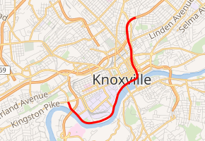
SR 158 is highlighted in red | ||||
| Route information | ||||
| Maintained by TDOT | ||||
| Length | 4.6 mi (7.4 km) | |||
| Major junctions | ||||
| West end | ||||
| East end | ||||
| Location | ||||
| Counties | Knox | |||
| Highway system | ||||
| ||||
The route is 4.6 miles (7.4 km) long. Its western terminus is at Kingston Pike (U.S. Route 11 or US 11, US 70, and SR 1). Its eastern terminus is at Interstate 40 (I-40) at exit 388A. Portions of the highway are known as Neyland Drive and James White Parkway.
Route description
SR 158 begins as a secondary highway known as Neyland Drive at an intersection with Kingston Pike (US 11/US 70/SR 1). It goes east as a 4-lane undivided highway to have an interchange with US 129/SR 115 (Alcoa Highway) before having an intersection with Joe Johnson Drive (SR 450). Neyland Drive then travels along the northern banks of the Tennessee River and the southern edge of the University of Tennessee campus, passing directly beside Thompson-Boling Arena and Neyland Stadium. It then runs along the southern edge of downtown, passing directly under the Henley Street Bridge and the Gay Street Bridge, before having an interchange for Volunteer Landing. SR 158 then makes a sharp turn to the north, leaving the riverbank, and has an interchange with SR 71, James White Parkway, where Neyland Drive ends and SR 158 becomes signed as a primary highway as it takes over James White Parkway from SR 71. SR 158 then has interchanges with Main Street, Cumberland Avenue, and Summit Hill Drive before coming to an end at an interchange with I-40 at exit 388A.
History
Prior to the Cumberland Avenue Streetscape project, which ran from 2015-2017, the Neyland Drive portion of the highway was signed solely as secondary SR 158. Due to this project, TDOT relinquished control of Cumberland Avenue and the easternmost portion of Kingston Pike to the city of Knoxville and rerouted US 11/US 70/SR 1 onto SR 158 and Neyland Drive.
Major intersections
The entire route is in Knoxville, Knox County.
| mi | km | Destinations | Notes | ||
|---|---|---|---|---|---|
| 0.0 | 0.0 | Kingston Pike to Cumberland Avenue - Downtown | Western terminus; western end of US 11/US 70/SR 1 concurrency; SR 158 begins as a now unsigned secondary highway | ||
| Interchange | |||||
| Western terminus of SR 450 | |||||
| Lake Loudoun Boulevard - University of Tennessee, Thompson-Boling Arena, Neyland Stadium | |||||
| Walnut Street - Knoxville Civic Coliseum, William Blount Mansion, James White Fort | Intersection with exit to Tennessee Riverboat Landing | ||||
| Volunteer Landing | Eastbound exit only; western end of freeway; SR 158 becomes a signed primary highway | ||||
| Eastern end of US 11/US 70/SR 1 concurrency | |||||
| Cumberland Avenue to | Westbound exit and eastbound entrance from Main Street | ||||
| Summit Hill Drive | Westbound exit and eastbound entrance from Hall of Fame Drive (US 11/US 70/SR 1/SR 71) | ||||
| 4.6 | 7.4 | Eastern terminus; I-40 exit 388A; SR 158 ends as a signed primary highway | |||
1.000 mi = 1.609 km; 1.000 km = 0.621 mi
| |||||
References
- Tennessee Department of Transportation (24 January 2003). "State Highway and Interstate List 2003".

