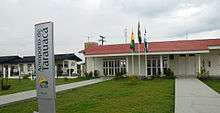
Tarauacá Airport
José Galera dos Santos Airport (IATA: TRQ, ICAO: SBTK) is the airport serving Tarauacá, Brazil.
José Galera dos Santos Airport Aeroporto José Galera dos Santos | |||||||||||
|---|---|---|---|---|---|---|---|---|---|---|---|
 | |||||||||||
| Summary | |||||||||||
| Airport type | Public | ||||||||||
| Serves | Tarauacá | ||||||||||
| Elevation AMSL | 646 m / 197 ft | ||||||||||
| Coordinates | 8°9′17″S 70°46′58″W | ||||||||||
| Map | |||||||||||
 TRQ Location in Brazil | |||||||||||
| Runways | |||||||||||
| |||||||||||
History
In December 2009, due to operational problems, the airport was temporarily closed. Consequently, the only way to reach the city of Tarauacá by air was via Feijó Airport, located 45 km away from the urban area of Tarauacá. Tarauacá was opened again on August 19, 2010 after undergoing a major renovations.[3]
Airlines and destinations
| Airlines | Destinations |
|---|---|
| Rio Branco Aerotaxi a | Feijó, Rio Branco |
a.^ Air taxi company operating systematic flights.
Access
The airport is located 3 km (2 mi) from downtown Tarauacá.
gollark: https://raw.githubusercontent.com/osmarks/skynet/master/client.lua ← raw link
gollark: The client API is right there and the server code is in the same repo.
gollark: The client API or server?
gollark: Anyway, it *does* rely on my personal server, which is... not entirely reliable, but mostly works.You can host your own and connect to that though.
gollark: You just `require` it and can then do stuff like```luaskynet.send(channel, message)local channel, message = skynet.receive(channel)```
See also
References
- "Tarauacá Airport Information". World Aero Data.
- "Lista de aeródromos públicos" (in Portuguese). ANAC.
- "Após 6 meses aeroporto de Tarauaça é liberado pela ANAC para pousos e decolagens" (in Portuguese). Câmara Municipal de Tarauacá. May 19, 2010. Archived from the original on March 6, 2016. Retrieved July 18, 2012.
External links
- Airport information for SBTK at World Aero Data. Data current as of October 2006.Source: DAFIF.
- Airport information for SBTK at Great Circle Mapper. Source: DAFIF (effective October 2006).
- Current weather for SBTK at NOAA/NWS
- Accident history for TRQ at Aviation Safety Network
This article is issued from Wikipedia. The text is licensed under Creative Commons - Attribution - Sharealike. Additional terms may apply for the media files.