Tagundaing, Kayin State
Tagundaing[3] or Ta Khun Taing[4] (Burmese: တံခွန်တိုင်; MLCTS: tam hkwan tuing, IPA: [dəɡʊ̀ɴ dàiɴ]; Phlone: စံင်မံင်ထုင်း; Thai: ดะกูนไดง์; Korean: 타군다잉; Russian: Тагундайн, also spelled Tagondaing) is a large village in the Kayin State of south-eastern Myanmar, located near the west bank of the Winyaw River and the west of the Kyain Seikgyi Township, Kawkareik District.[5][6]The population as of the 2014 census was 4,994. Most of the residents are of the Karen (Kayin) ethnic group.[7]
Tagondaing စံင်မံင်ထုင်း Tagundaing | |
|---|---|
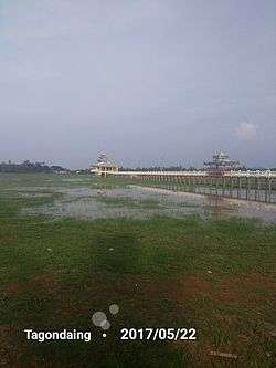 Tagondaing Ordination hall and Bridge | |
 Tagondaing Location of Tagondaing, Myanmar | |
| Coordinates: 16°3′59″N 97°54′27″E | |
| Country | |
| State | |
| District | Kawkareik District |
| Township | Kyain Seikgyi Township |
| Area | |
| • City | 2.43 sq mi (6.30 km2) |
| Elevation | 56 ft (17 m) |
| Population | |
| • City | 9,601 |
| • Density | 3,900/sq mi (1,500/km2) |
| • Urban | 4,994 |
| • Rural | 4,607 |
| • Religions | Buddhism, Islam |
| Time zone | UTC+6.30 (MMT) |
| • Summer (DST) | UTC16° 4' 3" North, 97° 54' 25" East |
| Area code(s) | 58[2] |
| Climate | Am |
The people in this village speak Kayin and Burma languages.
Nearby towns and villages include Kale (3.4 nm)north, Htimahto (6.4 nm)south-east, Phayanasu[8] (7.1 nm)north, Kawankathaung[9] (7.1 nm)east, Hlagazaing (7.5 nm)north, Myohaung (7.9 nm)north, Phathalē[10] (8.7 nm)east and Akalaw (11.0 nm)east.[11]
Etymology
In the Kayin, the word Somohto (စံင်မံင်ထုင်း) means monumental column or flagstaff. Thus, the village name of "'Tagundaing'" was derived from the local Kayin.[12]
History
The name of the village gets its name from a monumental column or flagstaff located in the village centre.
During World War II, the villagers worked on the construction of the Burma-Siam railroad with their cart as forced labourers.
Ministries and government organizations
Many federal agencies maintain offices in Tagondaing, such as Forestry, Health, Agriculture, Customs, Education and under the Ministry of Home Affairs as Police Station and Fire station.[13]
Transport
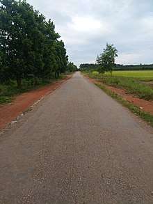
- The main artery road in the region is the Tagondaing-Kale-Phayanasu-Taungkalay Road, which is 16 kilometres (9.9 mi) long. It is connected by road to Kyainseikgyi-Mudon and via Mudon to Mawlamyine.
- The second main road is Tagondaing-Taungdi-Kyongawon-Phabya Road, it is connected Thanbyuzayat-Payathonzu Road(or Burmese-Siam Railroad), via Tanyin village.[14]
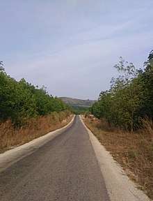
- Five miles by road to the west of village lie Abit village west of the Tenasserim Range, which road is connected to National Highway 8. Two miles is compacted.
- Ta Khun Taing - Kawan Ka Thaung Road is about two miles long, cross the Winyaw River.
Economy
It is a primary agricultural village, with extensive fields around it.
The village's economy is mainly based on rice, rubber and trade.
Education
Tagundaing has one public high school, one public post-primary school and four public primary schools.
- Basic Education High School Tagondaing[15]
- Post-Primary School (It is a post-primary school that is not a full middle school), formerly "No. 4 Basic Education Primary School"
- No. 1 Basic Education Primary School
- No. 2 Basic Education Primary School
- No. 3 Basic Education Primary School
- Basic Education Primary School (Tagundaing New Quarter)
Healthcare
- Kale-Tagundaing Station Hospital serves the people of Kale, Tagondaing and its surrounding areas.[16]
Climate
- Tagundaing has a tropical monsoon climate (Köppen climate classification Am). Temperatures are hot throughout the year, although maximum temperatures in the monsoon months are depressed by heavy cloud and rain. There is a winter dry season (November–April) and a summer wet season (May–October). Torrential rain falls from June to September, with over 1,200 millimetres (47 in) falling in August alone.
| Climate data for Tagundaing | |||||||||||||
|---|---|---|---|---|---|---|---|---|---|---|---|---|---|
| Month | Jan | Feb | Mar | Apr | May | Jun | Jul | Aug | Sep | Oct | Nov | Dec | Year |
| Average high °C (°F) | 31.7 (89.1) |
33.0 (91.4) |
33.8 (92.8) |
34.6 (94.3) |
30.0 (86.0) |
29.2 (84.6) |
28.5 (83.3) |
28.4 (83.1) |
29.5 (85.1) |
30.5 (86.9) |
31.5 (88.7) |
31.8 (89.2) |
31.0 (87.9) |
| Average low °C (°F) | 16.9 (62.4) |
17.3 (63.1) |
19.0 (66.2) |
21.5 (70.7) |
22.3 (72.1) |
22.0 (71.6) |
21.6 (70.9) |
21.8 (71.2) |
21.9 (71.4) |
21.4 (70.5) |
20.4 (68.7) |
17.9 (64.2) |
20.3 (68.6) |
| Average precipitation mm (inches) | 5 (0.2) |
3 (0.1) |
11 (0.4) |
57 (2.2) |
476 (18.7) |
1,076 (42.4) |
692 (27.2) |
1,261 (49.6) |
733 (28.9) |
259 (10.2) |
57 (2.2) |
11 (0.4) |
4,641 (182.5) |
| Source: NOAA (1961-1990)[17] | |||||||||||||
Geography
- Tagundaing or Tagondaing is located on the eastern side of the Tenasserim Range near the confluence of two tributaries of the Ataran River.
Places of interest
- Mahniyadanar Sandawshin Pagoda
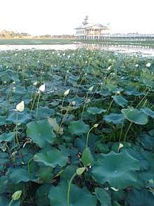
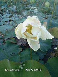
- White Padma lotus and many other families harvest plants such as the grass, can be found in this area.
Gallery
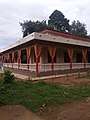 Wonnral Awar Dhammayone (Chapels)
References
- The 2014 Myanmar Population and Housing Census The Union Report Census Report Volume 2. Department of Population, Ministry of Immigration and Population. May 2015. p. 59. Archived from the original on 2016-03-06. Retrieved 2020-02-04.
- "Myanmar Area Codes". Archived from the original on 2009-12-01. Retrieved 2009-04-10.
- Tagundaing (Approved) at GEOnet Names Server, United States National Geospatial-Intelligence Agency
- "Township map of Kyainseikgyi" (PDF). Myanmar Information Management Unit (MIMU). 3 May 2016. Retrieved 10 February 2018.
- Google Maps (Map). Google.
|access-date=requires|url=(help) - Bing Maps (Map). Microsoft and Harris Corporation Earthstar Geographics LLC.
|access-date=requires|url=(help) - "Kayin Ethics and Traditional". Retrieved 16 February 2018.
- Phayanasu (Approved) at GEOnet Names Server, United States National Geospatial-Intelligence Agency
- Kawankathaung (Approved) at GEOnet Names Server, United States National Geospatial-Intelligence Agency
- Phathalē (Approved) at GEOnet Names Server, United States National Geospatial-Intelligence Agency
- Fallingrain world gazetteer
- ANCY POLLOCK KHIN. "Karen". Retrieved 17 February 2018.
- http://karennews.org/2018/04/residents-want-authorities-to-build-a-bridge-over-win-yaw-river/
- Tanyin (Approved) at GEOnet Names Server, United States National Geospatial-Intelligence Agency
- "Education statistics by level and by State and Division". Myanmar Central Statistical Organization. Archived from the original on 2008-05-24. Retrieved 2009-04-09.
- "Hospitals and Dispensaries by State and Division". Myanmar Central Statistical Organization. Archived from the original on 2011-04-30. Retrieved 2009-04-11.
- "Tagundaing Climate Normals 1961-1990". National Oceanic and Atmospheric Administration. Retrieved January 12, 2017.
External links


- "Tagundaing Map — Satellite Images of Tagundaing" Maplandia World Gazetteer
- "Burma 1:250,000 topographic map, Series U542, NE 47-14, Moulmein" U.S. Army May Service, December 1959
- "Tagundaing, Burma", Falling Rain Genomics, Inc.
- Tagundaing Weather in mirbig.net
- Tagundaing (Burma) 1994 - 2017, Photius Coutsoukis and Information Technology Associates
- Tagundaing Weather Forecast weather
|
Capital: Hpa-an | ||
| Hpa-an District | 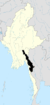 | |
| Hpapun District | ||
| Kawkareik District | ||
| Myawaddy District | ||
| Cities and towns | ||