T Third Street
The T Third Street is a Muni Metro line in San Francisco, California. It is the first new light rail line in San Francisco in more than half a century, and the first fully accessible line in the system. It is also the first true light rail line in the mostly streetcar Muni Metro system, as it operates mostly in a street median, rather than in mixed traffic.
Testing on the line took place in summer 2006,[3] with limited service starting on January 13, 2007, and full service beginning on April 7, 2007.[4] It runs along the newly constructed light-rail tracks on Third Street and Bayshore Boulevard in the Visitacion Valley, Bayview/Hunters Point, Dogpatch, and Mission Bay neighborhoods, connecting to the existing Muni Metro system along the southern Embarcadero and below Market Street, and replaced the 15 Third bus line.
In the future, the line may be extended to Caltrain's Bayshore Station (to which it was originally planned to run) and, in the other direction, to San Francisco's Washington Square in North Beach via Chinatown Central Subway alignment.
Operation
The T Third operates seven days a week, beginning at 5 a.m. weekdays, 6 a.m. Saturdays and 8 a.m. Sundays, operating until 1 a.m.[5] In 2018, Muni began running two-car trains on the line to increase capacity.[6]
Service is provided by overnight Owl buses during the hours that rail service is not running. The N Owl serves the portion between Embarcadero and 4th Street, and the 91 Owl serves the portion between 4th Street and Sunnydale. On weekends, KT Ingleside/Third Street Bus service runs from 5am until the start of rail service. The bus line largely follows the rail line, but it uses surface streets to parallel sections where the rail line has dedicated rights-of-way.[7]
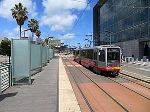
Leaving the Market Street subway at Ferry Portal heading south, the T Third follows The Embarcadero south of Market Street, then veers onto King Street in front of Oracle Park until it reaches the Caltrain station terminal. This portion of the Muni Metro rail line between the Embarcadero portal and the Caltrain terminal was built in 1998 and is utilized by an extension of the N Judah, which shares track with the T to the Caltrain terminal at 4th and King. From there the T turns south on Fourth Street, crossing the bridge over Mission Creek before joining Third Street for the majority of the route's length. It passes through Mission Bay where the UCSF Mission Bay branch is located, then continues on south through the Bayview and Hunters Point neighborhoods. Once both economically impoverished parts of the City, they have slowly experienced rehabilitation and rebuilding mainly helped by the new T line. At the intersection of Third and Jamestown Avenue, the T continues to run in both directions as it crosses U.S. Highway 101 (James Lick Freeway), although only Third Street is open to auto traffic northbound; likewise, southbound auto traffic is splintered to a southbound on ramp to Highway 101 and merges with San Bruno Avenue. From there the T follows Bayshore Boulevard (changed over from Third) for two more stations until it reaches its terminus at Sunnydale Station. A section of track follows one more block until stopped short at the Daly City limits.
All stations along this line feature high platforms, eliminating the need for the raising and lowering of entrance and exit steps characteristic of other Muni Metro lines. Stations south of Fourth and King feature short platforms that accommodate only two-car trains.
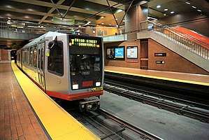
The T Third also uses the Muni Metro terminology in which an inbound train goes from West Portal to Embarcadero. This also means that an outbound T Third train runs from Sunnydale and out to the western neighborhoods via downtown.[8] This is the reverse of other lines, as those lines have their outer termini on the southwest and west sides of the city, and those trains enter the subway from the west going inbound toward downtown.
History
Current route
T Third Street service was operated between Castro station and Sunnydale station. Following service changes on June 30, 2007, the T Third Street and the K Ingleside lines were interlined through the Market Street subway and Twin Peaks tunnels, resulting in a combined route from Balboa Park, through downtown, to the Visitacion Valley neighborhood.[9]
The underground section of the line was closed west of Castro station from June 25 to August 24, 2018 due to the Twin Peaks Tunnel shutdown.[10] On August 25, 2018, at the conclusion of the shutdown, Muni began running permanently two-car trains on the K/T line (as had been used east of Castro during the shutdown).[11] The line was shut down from January 22, 2019 until April 1, 2019 for construction of a new platform at UCSF/Mission Bay station.[12][13] In April 2019, the SFMTA ended the use of unscheduled short turns. These had been used to provide more consistent service on the inner portion of the line, but had caused inconsistent and less frequent service in the Hunters Point-Bayview and Visitacion Valley neighborhoods.[14]
On March 30, 2020, Muni Metro service was replaced with buses due to the COVID-19 pandemic.[15] Rail service is expected to return in August 2020, with the routes reconfigured to improve reliability in the subway. M Ocean View and T Third Street service will be interlined, running between Sunnyvale station and Balboa Park station.[16]
Central Subway
T-Third has been built in phases. The second phase, currently under construction, is also known as the Central Subway project, and will reroute T-Third north of the 4th and King Station. The future alignment once the second phase is complete will neither share right-of-way with, nor share identities with the K Ingleside, avoiding both King Street and the congested Market Street subway. The southern segment from Sunnydale to 4th and King Street will remain as-is, operating on street-level tracks in the median of Third Street and Bayshore Boulevard. After 4th and King, the line will cross King Street instead of turning onto it, and proceed to a new 4th and Brannan Station, and the line will then burrow to subsurface level at Bryant Street Portal, near where 4th passes under Interstate 80.[17] Underground, the line will continue under Fourth Street, to Yerba Buena/Moscone Station, and then, after crossing Market Street, will turn slightly to continue under Stockton Street, continuing to Union Square/Market Station providing a transfer to Market Street subway MUNI and BART lines before running underneath Stockton Street and terminating at Chinatown Station.[17]
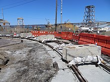
The Mission Bay Loop project, which added a short turn loop using 18th, Illinois, and 19th, was constructed to supplement the Central Subway project. The loop was originally designed in 1998 as part of the Third Street Light Rail project, but was deferred due to insufficient funding. A $3.5 million construction contract was issued in 2014.[18] Construction started in July 2016 and was completed in 2019.[19] When the Central Subway is complete, Muni intends to split the T Third service into short-line and long-line services.[20][21] The short-line service would run from Chinatown station to the Mission Bay Loop with 4-minute headways, while the long-line service would run the full route from Chinatown to Sunnydale station at 7.5-minute headways.[20] Another loop at 25th and Illinois is proposed to increase short-line service frequency between Downtown and Dogpatch.[6]
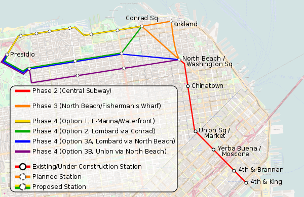
A proposed third phase would build an extension beyond Chinatown, including new stations at Washington Square in North Beach and Fisherman's Wharf.[17] In preparation, the tunnels were bored past Chinatown Station, and the tunnel boring machines were extracted from the intersection of Powell and Columbus, near Washington Square.[22][23] The SFMTA published a concept study in January 2015 on the feasibility of several options for phase 3.[23] The report studied three main alignments: Columbus Ave, Powell St, or a loop line on Powell St, Beach St, and Columbus Ave. Both subway and surface options were studied for each alignment. The report found that the phase 3 project could improve transit trip time by at least 50% and would increase the ridership on the T Third by 55%. Project cost estimates ranged from $440 million to $1.4 billion depending on the design. In June 2018, the SFMTA began a detailed study of possible routes to narrow down options for a future environmental impact study.[24]
A conceptual fourth phase has been advanced by SFMTA and transit advocates to further extend the line west of Fisherman's Wharf to the Presidio.[25][23] However, since the Central Subway station platforms will be about 250 feet (76 m) long, enough to accommodate two-car trains, unlike the upper deck Market Street subway platforms which can accommodate four-car LRV trains, the projected ridership increase with a fourth phase Presidio extension would require the stations currently under construction to be rebuilt to three- or four-car trains.[23]
Diagrams of the various T Third Street routings over its history | |||||||||||||||||||||||||||||||||||||||||||||||||||||||||||||||||||||||||||||||||||||||||||||||||||||||||||||||||||||||||||||||||||||||||||||||||||||||||||||||||||||||||||||||||||||||||||||||||||||||||||||||||||||||||||||||||||||||||||||||||||||||||||||||||||||||||||||||||||||||||||||||||||||||||||||||||||||||||||||||||||||||||||||||||||||||||||||||||||||||||||||||||||||||||||||||||||||||||||||||||||||||||||||||||||||||||||||||||||||||||||||||||||||||||||||||||||||||||||||||||||||||||||||||||||||||||||||||||||||||||||||||||||||||||||||||||||||||||||||||||||||||||||||||||||||||||||||||||||||||||||||||||||||||||||||||||||||||||||||||||||||||||||||||||||||||||||||||||||||||||||||||||||||||||||||||||||||||||||||||||||||||||||||||||||||||||||||||||||||||||||||||||||||||||||||||||||||||||||||||||||||||||||||||||||||||||||||||||||||||||||||||||||||||||||||||||||||||||||||||||||||||||||||||||||||||||||||||||||||||||||||||||||||||||||||||||||||||||||||||||||||||||||||||||||||||||||||||||||||||
|---|---|---|---|---|---|---|---|---|---|---|---|---|---|---|---|---|---|---|---|---|---|---|---|---|---|---|---|---|---|---|---|---|---|---|---|---|---|---|---|---|---|---|---|---|---|---|---|---|---|---|---|---|---|---|---|---|---|---|---|---|---|---|---|---|---|---|---|---|---|---|---|---|---|---|---|---|---|---|---|---|---|---|---|---|---|---|---|---|---|---|---|---|---|---|---|---|---|---|---|---|---|---|---|---|---|---|---|---|---|---|---|---|---|---|---|---|---|---|---|---|---|---|---|---|---|---|---|---|---|---|---|---|---|---|---|---|---|---|---|---|---|---|---|---|---|---|---|---|---|---|---|---|---|---|---|---|---|---|---|---|---|---|---|---|---|---|---|---|---|---|---|---|---|---|---|---|---|---|---|---|---|---|---|---|---|---|---|---|---|---|---|---|---|---|---|---|---|---|---|---|---|---|---|---|---|---|---|---|---|---|---|---|---|---|---|---|---|---|---|---|---|---|---|---|---|---|---|---|---|---|---|---|---|---|---|---|---|---|---|---|---|---|---|---|---|---|---|---|---|---|---|---|---|---|---|---|---|---|---|---|---|---|---|---|---|---|---|---|---|---|---|---|---|---|---|---|---|---|---|---|---|---|---|---|---|---|---|---|---|---|---|---|---|---|---|---|---|---|---|---|---|---|---|---|---|---|---|---|---|---|---|---|---|---|---|---|---|---|---|---|---|---|---|---|---|---|---|---|---|---|---|---|---|---|---|---|---|---|---|---|---|---|---|---|---|---|---|---|---|---|---|---|---|---|---|---|---|---|---|---|---|---|---|---|---|---|---|---|---|---|---|---|---|---|---|---|---|---|---|---|---|---|---|---|---|---|---|---|---|---|---|---|---|---|---|---|---|---|---|---|---|---|---|---|---|---|---|---|---|---|---|---|---|---|---|---|---|---|---|---|---|---|---|---|---|---|---|---|---|---|---|---|---|---|---|---|---|---|---|---|---|---|---|---|---|---|---|---|---|---|---|---|---|---|---|---|---|---|---|---|---|---|---|---|---|---|---|---|---|---|---|---|---|---|---|---|---|---|---|---|---|---|---|---|---|---|---|---|---|---|---|---|---|---|---|---|---|---|---|---|---|---|---|---|---|---|---|---|---|---|---|---|---|---|---|---|---|---|---|---|---|---|---|---|---|---|---|---|---|---|---|---|---|---|---|---|---|---|---|---|---|---|---|---|---|---|---|---|---|---|---|---|---|---|---|---|---|---|---|---|---|---|---|---|---|---|---|---|---|---|---|---|---|---|---|---|---|---|---|---|---|---|---|---|---|---|---|---|---|---|---|---|---|---|---|---|---|---|---|---|---|---|---|---|---|---|---|---|---|---|---|---|---|---|---|---|---|---|---|---|---|---|---|---|---|---|---|---|---|---|---|---|---|---|---|---|---|---|---|---|---|---|---|---|---|---|---|---|---|---|---|---|---|---|---|---|---|---|---|---|---|---|---|---|---|---|---|---|---|---|---|---|---|---|---|---|---|---|---|---|---|---|---|---|---|---|---|---|---|---|---|---|---|---|---|---|---|---|---|---|---|---|---|---|---|---|---|---|---|---|---|---|---|---|---|---|---|---|---|---|---|---|---|---|---|---|---|---|---|---|---|---|---|---|---|---|---|---|---|---|---|---|---|---|---|---|---|---|---|---|---|---|---|---|---|---|---|---|---|---|---|---|---|---|---|---|---|---|---|---|---|---|---|---|---|---|---|---|---|---|---|---|---|---|---|---|---|---|---|---|---|---|---|---|---|---|---|---|---|---|---|---|---|---|---|---|---|---|---|---|---|---|---|---|---|---|---|---|---|---|---|---|---|---|---|---|---|---|---|---|---|---|---|---|---|---|---|---|---|---|---|---|---|---|---|---|---|---|---|---|---|---|---|---|---|---|---|---|---|---|---|---|---|---|---|---|---|---|---|---|---|---|---|---|---|---|---|---|---|---|---|---|---|---|---|---|---|---|---|---|---|---|---|---|---|---|---|---|---|---|---|---|---|---|---|---|---|---|---|---|---|---|---|---|---|---|---|---|---|---|---|---|---|---|---|---|---|---|---|---|---|---|---|---|---|---|---|---|---|---|---|---|---|---|---|---|---|---|---|---|---|---|---|---|---|---|---|---|---|---|---|---|---|---|---|---|---|---|---|---|---|---|---|---|---|---|---|---|---|---|---|---|---|---|---|---|---|---|---|---|---|---|---|---|---|---|---|---|---|
| |||||||||||||||||||||||||||||||||||||||||||||||||||||||||||||||||||||||||||||||||||||||||||||||||||||||||||||||||||||||||||||||||||||||||||||||||||||||||||||||||||||||||||||||||||||||||||||||||||||||||||||||||||||||||||||||||||||||||||||||||||||||||||||||||||||||||||||||||||||||||||||||||||||||||||||||||||||||||||||||||||||||||||||||||||||||||||||||||||||||||||||||||||||||||||||||||||||||||||||||||||||||||||||||||||||||||||||||||||||||||||||||||||||||||||||||||||||||||||||||||||||||||||||||||||||||||||||||||||||||||||||||||||||||||||||||||||||||||||||||||||||||||||||||||||||||||||||||||||||||||||||||||||||||||||||||||||||||||||||||||||||||||||||||||||||||||||||||||||||||||||||||||||||||||||||||||||||||||||||||||||||||||||||||||||||||||||||||||||||||||||||||||||||||||||||||||||||||||||||||||||||||||||||||||||||||||||||||||||||||||||||||||||||||||||||||||||||||||||||||||||||||||||||||||||||||||||||||||||||||||||||||||||||||||||||||||||||||||||||||||||||||||||||||||||||||||||||||||||||||
Station and stop listing
outbound to inbound
| Station | Neighborhood | Other Muni Metro lines |
Notes |
|---|---|---|---|
| West Portal | Sign change from M Ocean View inbound | ||
| Forest Hill and Laguna Honda | |||
| Castro | |||
| Duboce Triangle | Connects with J Church on surface stop at 14th Street Connects with F Market & Wharves streetcar | ||
| Civic Center and Tenderloin | Connects to F Market & Wharves | ||
| Civic Center | Connects to F Market & Wharves and BART | ||
| Financial District | Connects to F Market & Wharves and BART | ||
| Financial District | Connects to F Market & Wharves and BART | ||
| Financial District | Changes to M Ocean View outbound Connects to F Market & Wharves and BART Serves Ferry Building | ||
| Financial District | Connects to E Embarcadero | ||
| South Beach | Connects to E Embarcadero | ||
| Mission Bay | Connects to E Embarcadero Serves Oracle Park | ||
| Mission Bay | Connects to E Embarcadero and N Judah via separate platform nearby Serves Caltrain | ||
| Mission Bay | |||
| Mission Bay | Serves the UCSF Mission Bay Campus and Chase Center | ||
| Mission Bay | |||
| Dogpatch | |||
| Dogpatch | |||
| Bayview | |||
| Bayview | |||
| Bayview | |||
| Bayview | |||
| Bayview | |||
| Bayview | |||
| Bayview | |||
| Bayview | |||
| Bayview | |||
| Bayview | |||
| Visitacion Valley | |||
| Visitacion Valley | Inbound terminus |
Future
| Station | Neighborhood | Other Muni Metro lines |
Notes |
|---|---|---|---|
| Chinatown | Future terminus | ||
| Financial District | Underground pedestrian pathway to Powell Street station | ||
| SoMa | |||
| SoMa |
References
- "TEP Route Data & Proposed Changes". San Francisco Municipal Transportation Agency (SFMTA). 2013. Retrieved 2013-12-15.
- "2007 Annual Report" (PDF). San Francisco County Transportation Authority. p. 16.
- Gordon, Rachel (July 26, 2006). "Third Street seeing streetcars / Test runs for light-rail project begin at last". San Francisco Chronicle. Retrieved 2013-12-15.
- Cabanatuan, Michael (January 12, 2007). "T-Third Muni line starts service Saturday". San Francisco Chronicle. Retrieved 2013-12-15.
- "Schedule & Route Maps – KT – (Muni (SFMTA)) Ingleside/Third Street – Metro: Inbound toward Sunnydale via Downtown. Outbound toward Balboa Park Station eff. Sept. 4 via Downtown and West Portal. No bikes". Transit.511.org. Retrieved 2013-12-15.
- Swan, Rachel (October 19, 2018). "The T line has never lived up to its promise. Coming upgrades may not be enough to help". San Francisco Chronicle. Retrieved 24 October 2018.
- "Permanent Muni Service Changes Starting Saturday, February 22, 2020" (Press release). San Francisco Municipal Transportation Agency. February 22, 2020.
- "KT-Ingleside/Third Street". San Francisco Municipal Transportation Agency (SFMTA). Retrieved 2013-12-15.
- Gordon, Rachel (June 4, 2007). "T-Third line causing delays, so officials consider new routes". San Francisco Chronicle. Retrieved 2013-12-15.
- "Twin Peaks Tunnel Improvements". San Francisco Municipal Transportation Agency. June 25, 2018. Archived from the original on June 26, 2018.
- von Krogh, Bonnie Jean (August 24, 2018). "Two-Car Trains Now Permanent on K/T Line" (Press release). San Francisco Municipal Transportation Agency.
- "T Third Bus Substitution". San Francisco Municipal Transportation Agency. Archived from the original on January 20, 2019.
- McMillan, Erin (March 29, 2019). "T Third Back In Action" (Press release). San Francisco Municipal Transportation Agency.
- "SFMTA to Stop Switching Back Trains on the T Third Line" (PDF) (Press release). San Francisco Municipal Transportation Agency. April 9, 2019.
- Fowler, Amy (March 26, 2020). "Starting March 30: New Muni Service Changes" (Press release). San Francisco Municipal Transportation Agency.
- Maguire, Mariana (June 18, 2020). "Big Changes Ahead when Muni Rail Returns in August" (Press release). San Francisco Municipal Transportation Agency.
- Vega, Cecilia M. (20 February 2008). "S.F. Chinatown subway plan gets agency's nod". San Francisco Chronicle. Retrieved 10 March 2017.
- "SFMTA board approves contract for Mission Bay loop project". San Francisco Examiner. September 18, 2014.
- "Mission Bay Loop". San Francisco Municipal Transit Agency. Retrieved 24 October 2018.
- SFMTA (2013-05-06). Environmental Assessment for Mission Bay Transit Loop Project (PDF) (Report). Retrieved 2018-10-23.
- Rodriguez, Joe Fitzgerald (2018-07-23). "Cost for long delayed Muni 'loop' to boost Warriors train service jumps $1.4 million". San Francisco Examiner. Retrieved 2018-10-23.
- Cabanatuan, Michael (26 November 2014). "Extending S.F.'s Central Subway would draw riders, study says". San Francisco Chronicle. Retrieved 10 March 2017.
- T-Third – Phase 3 Concept Study (PDF) (Report). San Francisco Municipal Transportation Agency, Sustainable Streets Division. October 2014. Retrieved 10 March 2017.
- Rodriguez, Joe Fitzgerald (2018-06-13). "Planning begins for Central Subway extension to Fisherman's Wharf". San Francisco Examiner. Retrieved 2018-06-15.
- Bialick, Aaron (5 December 2014). "Extending the Central Subway: Why Stop at Fisherman's Wharf?". Streetsblog SF. Retrieved 10 March 2017.
External links
| Wikimedia Commons has media related to T Third Street. |
- SFMTA - K Ingleside/T Third Street
- Wilbur Smith Associates (1993). Bayshore Transit Study (Report). City and County of San Francisco, San Francisco Municipal Railway. Retrieved 10 March 2017.
- "Central Subway Extension: Phase III of the T Third Rail project". San Francisco Municipal Transit Agency. Retrieved 24 October 2018.
| Muni Metro | |||||||
|---|---|---|---|---|---|---|---|
| Muni Metro system features |
| ||||||
| Heritage streetcar services | |||||||
| Other Muni services | |||||||
| Projects |
| ||||||
| Miscellaneous |
| ||||||