Swainby
Swainby is a village in the Hambleton District of North Yorkshire, England. It is situated on the A172 road, 8 miles (13 km) north-east from Northallerton and 5 miles (8 km) south-east from the small market town of Stokesley.[2]
| Swainby | |
|---|---|
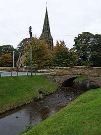
 Scugdale Beck at Swainby with Holy Cross Church in the background | |
 Swainby Location within North Yorkshire | |
| Population | 1,820 (2011 census)[1] |
| OS grid reference | NZ477019 |
| • London | 215 mi (346 km) south |
| Civil parish | |
| District | |
| Shire county | |
| Region | |
| Country | England |
| Sovereign state | United Kingdom |
| Post town | NORTHALLERTON |
| Postcode district | DL6 |
| Dialling code | 01642 |
| Police | North Yorkshire |
| Fire | North Yorkshire |
| Ambulance | Yorkshire |
| UK Parliament |
|
Overview
Swainby is located at the north-western corner of the North York Moors National Park.[3] The characteristics of the village and the surrounding area consist of traditional Yorkshire dry stone walls, hills, sheep, heather and moorland.[4] The name of the village derives from Old Norse, Sveins and by which means the village next to the swans or the land of Svein's people.[5]
The village is close to the ruins of Whorlton Castle; Swainby appears to have been built after its abandonment, possibly due to the Black Death (or some other disease) leaving the inhabitants of the castle low in number in 1428.[6]
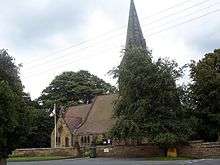
Holy Cross Church (Church of England) was designed by T. H. Wyatt; he was commissioned to do it by the Marquess of Ailesbury. It is in the Early English style and constructed of locally quarried stone. The grade II listed church was consecrated on 4 October 1877.[7]
In the 19th century the housing of miners who worked the nearby hills for ironstone and jet led to an expansion of the village.[8] Scugdale Beck, a tributary of the River Leven, cuts northwards through the village with two roads either side of the water and houses built on both sides.[9][10][11]
Swainby contains two public houses, "The Blacksmiths Arms" and "The Black Horse", and a caravan park with farm house.
Governance
Although Swainby is in Whorlton civil parish it has retained an electoral ward in its own name. The population of this ward taken at the 2011 census was 1,820.[1]
Transport
Swainby was the site where an old drover's road entered the North York Moors. The road continued south to Sutton Bank where it fed into the prehistoric road that is now the A170. Cattle from Ryedale were brought up to Swainby to be sold in the village.[12][13]
The village is just south of the A172 road which connects the A19 road with Middlesbrough bypassing Stokesley. The village lies on the Northallerton to Stokesley bus route.[14]
A railway ran through the village between 1857 and 1899. It connected with Potto railway station on the Picton–Battersby line but it was not open to passenger traffic, being used to move ironstone from Whorlton to the smelters on Teesside only.[15]
References
- UK Census (2011). "Local Area Report – Swainby Ward (as of 2011) (1237325082)". Nomis. Office for National Statistics. Retrieved 4 November 2018.
- "History of Swainby, in Hambleton and North Riding | Map and description". www.visionofbritain.org.uk. Retrieved 31 January 2019.
- "OL26" (Map). North York Moors - Western area. 1:25,000. Explorer. Ordnance Survey. 2016. ISBN 9780319242650.
- Bagshaw, Mike (2014). Slow Yorkshire Moors & Wolds : including York & the coast. Chalfont St Peter: Bradt. p. 23. ISBN 978-1-84162-548-5.
- Ekwall, Eilert (1960). The concise Oxford dictionary of English place-names (4 ed.). Oxford: Oxford University Press. p. 455. ISBN 0-19-869103-3.
- Chrystal, Paul (2017). The Place Names of Yorkshire. Catrine: Stenlake. p. 80. ISBN 9781840337532.
- Historic England. "Church of Holy Cross (Grade II) (1314939)". National Heritage List for England. Retrieved 31 January 2019.
- Whitworth, Alan (2011). In & around the North York moors through time. Stroud: Amberley Pub. p. 84. ISBN 978-1-4456-0599-9.
- "Genuki: WHORLTON: Geographical and Historical information from the year 1890., Yorkshire (North Riding)". www.genuki.org.uk. Retrieved 31 January 2019.
- "Parishes: Whorlton | British History Online". www.british-history.ac.uk. Retrieved 31 January 2019.
- "Potto Beck Catchment (trib of Leven)". environment.data.gov.uk. Retrieved 31 January 2019.
- "The history of Sutton Bank - always a popular place to be". Darlington and Stockton Times. 26 October 2007. Retrieved 31 January 2019.
- Peach, Howard (2004). Curious tales of old North Yorkshire. Wilmslow: Sigma Leisure. p. 72. ISBN 1-85058-793-0.
- "Weekend Walk: Swainby and Live Moor". The Yorkshire Post. 11 November 2017. Retrieved 31 January 2019.
- Hoole, Ken (1974). A regional history of the railways of Great Britain. Vol. 4, North East England. Newton Abbot: David & Charles. p. 73. ISBN 0-7153-6439-1.
External links
| Wikimedia Commons has media related to Swainby. |
