Sucker Brook (Lawrence Brook tributary)
Sucker Brook is a tributary of Lawrence Brook in central New Jersey in the United States.
| Sucker Brook | |
|---|---|
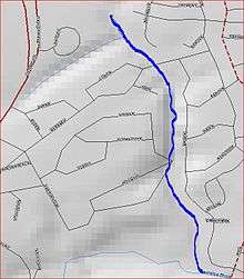 Map of Sucker Brook | |
| Location | |
| Country | United States |
| Physical characteristics | |
| Source | |
| • coordinates | 40°27′40″N 74°27′09″W |
| Mouth | |
• coordinates | 40°26′58″N 74°26′52″W |
• elevation | 23 ft (7.0 m) |
| Basin features | |
| Progression | Lawrence Brook, Raritan River, Atlantic Ocean |
Course
The source of Sucker Brook is several pools located in a housing development at 40°27′40″N 74°27′09″W. It travels in a pipe under Route 130, and then runs between a housing development. It drains into Lawrence Brook at 40°26′58″N 74°26′52″W near Westons Mill Pond, a dammed section of Lawrence Brook.[1]
Sister tributaries
- Beaverdam Brook
- Great Ditch
- Ireland Brook
- Oakeys Brook
- Sawmill Brook
- Terhune Run
- Unnamed Brook in Rutgers Gardens, unofficially named Doc Brook
- Unnamed Brook in Rutgers' Helyar Woods
History
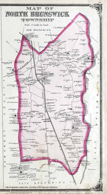
Map of North Brunswick, New Jersey, 1876. Sucker Brook flows to Lawrence Brook below Milltown at the upper right.
An 1876 map of North Brunswick shows that Sucker Brook at one time transversed the present day U.S. 1, Milltown Road, 4th, 3rd, 2nd, 1st Avenues, and Allgair Avenue, and ended near Nassau Street east of George's Road.
gollark: No, I was not citing my wonderful and excellent code.
gollark: Even projects with really good developers sometimes contain mistakes.
gollark: It's boring. And you can still make safety mistakes.
gollark: Since real people *do* make mistakes and have to handle errors, C with those features would not deprecate Rust/Zig/etc.
gollark: Yes, just write code which is right all the time and you don't NEED safety checks.
See also
References
- "USGS GNIS - Sucker Brook". USGS. Retrieved July 10, 2020.
This article is issued from Wikipedia. The text is licensed under Creative Commons - Attribution - Sharealike. Additional terms may apply for the media files.