Terhune Run
Terhune Run is a tributary of Lawrence Brook in eastern South Brunswick, New Jersey in the United States.
| Terhune Run | |
|---|---|
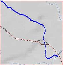 Terhune Run map | |
| Location | |
| Country | United States |
| Physical characteristics | |
| Source | |
| • coordinates | 40°24′1″N 74°32′29″W |
| Mouth | |
• coordinates | 40°23′22″N 74°31′51″W |
• elevation | 79 ft (24 m) |
| Basin features | |
| Progression | Lawrence Brook, Raritan River, Atlantic Ocean |
| River system | Raritan River system |
Course
Terhune Run starts at 40°24′1″N 74°32′29″W,[1] near the intersection of Route 1 and Major Road. It flows south, crossing Major Road, until it drains into Lawrence Brook at 40°23′22″N 74°31′51″W,[1] in Reichler Park.
Accessibility
Terhune Run is short, crossing one road, making it hard to access.
Sister tributaries
- Beaverdam Brook
- Great Ditch
- Ireland Brook
- Oakeys Brook
- Sawmill Brook
- Sucker Brook
- Unnamed Brook in Rutgers Gardens, unofficially named Doc Brook
- Unnamed Brook in Rutgers' Helyar Woods
gollark: SBCs are getting ridiculous.
gollark: Unrelatedly, https://www.pine64.org/?page_id=61454
gollark: Yes.
gollark: More great "WHY WOULD YOU DO THIS":```go// A Context carries a deadline, cancelation signal, and request-scoped values// across API boundaries. Its methods are safe for simultaneous use by multiple// goroutines.type Context interface { // Done returns a channel that is closed when this Context is canceled // or times out. Done() <-chan struct{} // Err indicates why this context was canceled, after the Done channel // is closed. Err() error // Deadline returns the time when this Context will be canceled, if any. Deadline() (deadline time.Time, ok bool) // Value returns the value associated with key or nil if none. Value(key interface{}) interface{}}```
gollark: Basically, modems/rednet but more flexible, cross-server, and without actual modems.
See also
This article is issued from Wikipedia. The text is licensed under Creative Commons - Attribution - Sharealike. Additional terms may apply for the media files.