Sawmill Brook (New Jersey)
Sawmill Brook is a tributary of Lawrence Brook in northwestern East Brunswick, New Jersey in the United States.
| Sawmill Brook | |
|---|---|
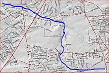 Sawmill Brook map | |
| Location | |
| Country | United States |
| Physical characteristics | |
| Source | |
| • coordinates | 40°26′35″N 74°23′58″W |
| Mouth | |
• coordinates | 40°27′34″N 74°25′53″W |
• elevation | 20 ft (6.1 m) |
| Basin features | |
| Progression | Lawrence Brook, Raritan River, Atlantic Ocean |
Course
The Sawmill Brook's official source is at 40°26′35″N 74°23′58″W.[1] It runs through the industrialized section between Harts Lane and Route 18. It then crosses Harts Lane and runs through Tices Lane Park. Another branch from the south joins it, and it crosses Tices Lane. It crosses the New Jersey Turnpike and Ryders Lane, and drains into Westons Mill Pond, a dammed section of Lawrence Brook, at 40°27′34″N 74°25′53″W.
Accessibility
Sawmill Brook runs through heavily populated areas, so it is easy to access.
Sister tributaries
- Beaverdam Brook
- Great Ditch
- Ireland Brook
- Oakeys Brook
- Sucker Brook
- Terhune Run
- Unnamed Brook in Rutgers Gardens, unofficially named Doc Brook
- Unnamed Brook in Rutgers' Helyar Woods
gollark: I see enough awful code when I look at my code.
gollark: I have fixed it in the development copy now.
gollark: .
gollark: Oops, yes, minor indent failure/
gollark: I have decided to write one on the osmarks.net tech stack.
See also
- List of rivers in New Jersey
References
- "USGS GNIS - Sawmill Brook". USGS. Retrieved 9 June 2010.
This article is issued from Wikipedia. The text is licensed under Creative Commons - Attribution - Sharealike. Additional terms may apply for the media files.