Subtropical Storm One (1974)
Subtropical Storm One was a short-lived subtropical cyclone that brought copious amounts of rainfall to central Florida in late June 1974. The storm originated in an area of convection that detached from a tropical depression over the southwestern Gulf of Mexico on June 24. A new area of low pressure developed underneath the convection and the system began to intensify. Later that day, the storm had become sufficiently organized to be classified as a subtropical depression. Early on June 25, it made landfall near Clearwater, Florida with winds of 50 mph (85 km/h) and later attained its peak intensity over eastern Florida with winds of 65 mph (100 km/h). After reemerging into the Atlantic Ocean, the system began to weaken as it underwent an extratropical transition. The storm ultimately dissipated off the coast of North Carolina early on June 26.
| Subtropical Storm (SSHWS/NWS) | |
 The subtropical storm on June 24 off the west coast of Florida | |
| Formed | June 22, 1974 |
|---|---|
| Dissipated | June 27, 1974 |
| (Extratropical after June 25, 1974) | |
| Highest winds | 1-minute sustained: 65 mph (100 km/h) |
| Lowest pressure | 1000 mbar (hPa); 29.53 inHg |
| Fatalities | 3 direct |
| Damage | $10 million (1974 USD) |
| Areas affected | Southeastern United States, especially Florida |
| Part of the 1974 Atlantic hurricane season | |
Despite its relatively weak strength, the system produced nearly 12 in (300 mm) of rain around Tampa, Florida, and the National Hurricane Center reported upwards of 20 in (510 mm) nearby. Around Lake Okeechobee, precipitation totals of 7 in (180 mm) were common. The heavy rainfall led to moderate flooding across the state. One tornado was confirmed to have touched down in association with the cyclone. Three people drowned as a result of the storm and damage amounted to $10 million (1974 USD, $51.8 million in 2009 USD).
Meteorological history
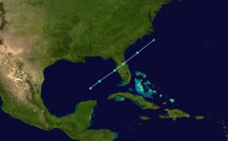
A tropical depression was situated over the southwestern Gulf of Mexico on June 22, 1974. By June 24, the depression began to weaken as it moved near the Mexican coastline, causing convective activity to move away from the center of circulation. Later that day, a new area of low pressure developed underneath the convection in the central Gulf of Mexico.[1] It continued to mature, and around 1800 UTC, the system had become sufficiently organized to be classified as a subtropical depression.[2] Although subtropical, the storm was operationally considered to be non-tropical,[3] but was reassessed in a post-season analysis of the system.[1] Upon becoming subtropical, the storm tracked rapidly towards the northeast at 24 mph (39 km/h). Early on June 25, the depression intensified into a subtropical storm as it neared the Florida coastline.[2]
Reconnaissance missions were flown into the storm until it made landfall near Clearwater, Florida with winds of 50 mph (85 km/h) during the morning of June 25.[1][2] Although over land, the system continued to intensify as it moved through the Florida Peninsula.[1] Roughly six-hours after landfall, the storm attained its peak intensity with winds of 65 mph (100 km/h) and a barometric pressure of 1000 mbar (hPa; 29.53 inHg).[2] Not long after attaining this intensity, the storm moved over the far western Atlantic Ocean and began to weaken. Later that day, it began to undergo an extratropical transition, acquiring frontal features and elongated convection. The storm completed this transition within 12 hours before becoming poorly defined and dissipating off the North Carolina coastline early on June 26.[1][2]
Preparations and impact
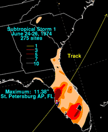
Following the formation of the system, the National Hurricane Center issued small craft advisories and gale warnings for most of the Florida coastline.[3] Although it was relatively weak, the system brought torrential rainfall to parts of central Florida,[3] with amounts of 11.38 in (289 mm) in St. Petersburg.[4] The National Hurricane Center reported that up to 20 in (510 mm) fell near Tampa.[1] In a 24-hour span, 9.54 in (242 mm) of rain fell in Inverness.[3] Rainfall amounts exceeding 7 in (180 mm) covered a large area north of Tampa and totals between 5 and 7 in (130 and 180 mm) were common west of Lake Okeechobee.[4] Two runways at the St. Petersburg-Clearwater International Airport were submerged in flood waters during the storm.[5]
Offshore, waves up to 4 ft (1.2 m) affected coastal areas. Several vessels became stranded in the storm, resulted in many Coast Guard rescues, many by towing the ships back to shore.[3] A tornado was reported near Fort Myers.[6] Additionally, two waterspouts touched down near Sarasota; however, both struck unpopulated areas and left no damage.[3] One of the two waterspouts was later confirmed as an F0 tornado with a track length of roughly 1 mi (1.6 km).[7] Beach erosion was common along many beaches in southeastern states.[8] The most significant erosion took place between Cedar Key and Naples where coastal flooding was reported.[9] After moving through Florida, the subtropical storm brought gusty winds and light to moderate rainfall to Georgia, South Carolina and North Carolina.[8] Throughout Florida, three people were killed by the storm from drowning and floods left roughly $10 million (1974 USD, $51.8 million in 2009 USD) in damage.[1]
See also
References
- John R. Hope (April 1975). "Atlantic Hurricane Season of 1975" (PDF). National Hurricane Center. Retrieved December 30, 2009.
- Hurricane Research Division (2009). "Easy-to-Read HURDAT 1851-2008". National Hurricane Center. Retrieved December 30, 2009.
- United Press International (June 26, 1974). "Storm Lashes Florida". Bangor Daily News. p. 8. Retrieved December 30, 2009.
- David M. Roth (2009). "Subtropical Storm 1 - June 24–26, 1974". Hydrometeorological Prediction Center. Retrieved December 30, 2009.
- United Press International (June 26, 1974). "Storm claws at Florida". The Deseret News. p. 5. Retrieved December 30, 2009.
- United Press International (June 25, 1974). "Depression drifts off Florida". Bangor Daily News. p. 2. Retrieved December 30, 2009.
- Stuart Hinson (2009). "Florida Event Report: F0 Tornado". National Climatic Data Center. Retrieved December 30, 2009.
- Associated Press (June 26, 1974). "Depression Becoming Storm?". Daytona Beach Sunday News-Journal. p. 2. Retrieved December 30, 2009.
- United Press International (June 25, 1974). "Cold front weakens depression". Bangor Daily News. p. 4. Retrieved December 30, 2009.