Subtropical Cyclone Katie
Subtropical Cyclone Katie, unofficially named by researchers, was an unusual weather event in early 2015. After the 2014–15 South Pacific cyclone season had officially ended, a rare subtropical cyclone was identified outside of the basin near Easter Island, during early May, and was unofficially dubbed Katie by researchers.[1] Katie was one of the few tropical or subtropical systems ever observed forming in the far Southeast Pacific, outside of the official basin boundary of 120°W, which marks the eastern edge of RSMC Nadi's and RSMC Wellington's warning areas, during the satellite era.[2] Due to the fact that this storm developed outside of the official areas of responsibility of the warning agencies in the South Pacific, the storm was not officially included as a part of the 2014–15 South Pacific cyclone season. However, the Chilean Navy Weather Service issued High Seas Warnings on the system as an extratropical low.[3]
| Subtropical cyclone (SSHWS) | |
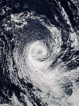
 The storm near peak intensity, on May 2 | |
| Formed | April 29, 2015 |
|---|---|
| Dissipated | May 6, 2015 |
| (Remnant low after May 4) | |
| Highest winds | 1-minute sustained: 75 km/h (45 mph) |
| Lowest pressure | 993 hPa (mbar); 29.32 inHg |
| Fatalities | None |
| Damage | None |
| Areas affected | Easter Island |
| Part of the 2014–15 South Pacific cyclone season (unofficially) | |
Meteorological history

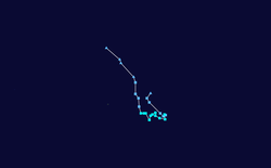
On April 29, 2015, near the end of the 2014–15 South Pacific cyclone season, an extratropical disturbance developed in the far Southeastern Pacific, before transitioning into a subtropical depression soon afterward.[4] The storm transitioned into a subtropical depression at 102.9°W, well to the east of the South Pacific basin's eastern boundary of 120°W.[4][2] Around this time, the Chilean Navy Weather Service began including the storm in their High Seas Warnings, continuing this until May 4.[3] During the next couple of days, the system drifted to the southwest, before turning to the southeast. On May 1, the storm intensified into a subtropical cyclone of tropical storm intensity, and looped westward.[4] During this time, the system encountered water temperatures about 1 °C above average and low wind shear, due to an extremely strong El Niño event, allowing the storm to organize further.[1] On May 2, the storm reached its peak intensity, with maximum sustained winds of 72 km/h (45 mph; 39 kn),[4][nb 1] and a minimum low pressure of 993 hPa (29.32 inHg).[3] Around this time, the storm was identified by researchers and unofficially named Katie.[1] During the next day, Katie slowly tracked westward while gradually weakening. On May 4, Katie weakened into a subtropical depression and began accelerating to the northwest, passing to the east of Easter Island, before weakening further into a remnant low.[4] With this degeneration, the Chilean Navy Weather Service ceased issuing warnings on the storm.[3] On May 6, Katie's remnant low dissipated.[3] During Katie's entire existence, the storm remained east of 120°W, outside of the South Pacific basin's official boundary.[4][3]
Records
Subtropical Cyclone Katie is unofficially the second-easternmost tropical or subtropical cyclone ever observed to form in the South Pacific Ocean, transitioning into a subtropical system near 102.9°W.[1][4] This broke the previous record of around 110°W, set by a tropical depression in May 1983.[5] "Katie" was also the first tropical or subtropical system to form east of the South Pacific basin's official eastern boundary of 120°W[2] since another tropical depression in May 1983.[5] However, in May 2018, Katie's record was broken by Subtropical Cyclone Lexi, which formed just a few hundred miles off the coast of Chile, near 80°W.[6][7] Tropical cyclogenesis is extremely rare in the far southeastern Pacific Ocean, due to the cold sea-surface temperatures generated by the Humboldt Current, lack of tropical disturbance formation, and also due to unfavorable wind shear; as such, there are no records of a tropical cyclone impacting western South America.[8] Tropical cyclone formation in this extreme part of the Southeast Pacific is so rare that no warning agencies have yet been assigned to the region east of 120°W.[1] Subtropical Cyclone Katie formed during an extremely strong El Niño event; the abnormally-warm waters 1 °C above average and low wind shear across the region may have contributed to the system's rare formation.[1] Although Katie's observed characteristics were consistent with that of a subtropical cyclone, detailed analysis revealed that the storm may have briefly transitioned into a tropical cyclone, around the time of its peak intensity.[3]
Notes
- All wind speeds in the article are maximum sustained winds sustained for one minute, unless otherwise noted.
See also
| Wikimedia Commons has media related to 2015 Southeast Pacific cyclone. |
- Subtropical Cyclone Lexi
- 2006 Central Pacific cyclone
- Hurricane Catarina
- Tropical Storm Rolf
- Cyclone Qendresa
- Cyclone Numa
- 1996 Lake Huron cyclone
- Mediterranean tropical-like cyclone
- South Atlantic tropical cyclone
- 1982–83 South Pacific cyclone season
- 2017–18 South Pacific cyclone season
- Tropical cyclone basins
- Tropical cyclogenesis
- El Niño–Southern Oscillation
References
- Diamond, Howard J (August 25, 2015). "Review of the 2014/15 Tropical Cyclone Season in the Southwest Pacific Ocean Basin". Climate Program Office. National Oceanic and Atmospheric Administration. Retrieved October 16, 2017.
- RA V Tropical Cyclone Committee (November 12, 2012). Tropical Cyclone Operational Plan for the South-East Indian Ocean and the Southern Pacific Ocean 2012 (PDF) (Report No. TCP-24). World Meteorological Organization. pp. 15–20. Archived (PDF) from the original on March 29, 2015. Retrieved March 29, 2015.
- Blunden, J.; D. S. Arndt (October 2016). "State of the Climate in 2015". State of the Climate. American Meteorological Society. 97 (8): 149–150. doi:10.1175/2016BAMSStateoftheClimate.1.
- Steve Young (27 July 2015). "Monthly Global Tropical Cyclone Tracks April 2015". Australia Severe Weather. Retrieved 16 October 2017.
- Pacific ENSO Update — Quarter 1, 1998. Pacific ENSO Update (Report). 4. The Pacific ENSO Applications Climate Centre. Archived from the original on April 1, 2014.
- Levi Cowan (May 7, 2018). "Subtropical Cyclone". Twitter. Retrieved May 10, 2018.
- John Leslie (May 9, 2018). "Rare Subtropical Storm off the Coast of Chile". NOAA. Retrieved May 10, 2018.
- Jonathan Belles (May 9, 2018). "Extremely Rare Southeast Pacific Subtropical Cyclone Forms Off the Chilean Coast". weather.com. The Weather Company. Retrieved June 25, 2019.
