Strathcona Regional District
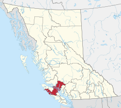
The Strathcona Regional District is a regional district in British Columbia, Canada. It was created on February 15, 2008, encompassing the northern and western portions of the former Regional District of Comox-Strathcona. The partition left the new Strathcona Regional District with 91.6 percent of the former Comox-Strathcona's land area, but only 42.1 percent of its population. Its current territory has a land area of 18,329.948 km² (7,077.232 sq mi) and a 2016 census population of 44,671 inhabitants. There are 21 named Indian reserves within its territory, with a combined 2016 census population of 1,579 and combined land area of 16.444 km² (6.345 sq mi).
Strathcona | |
|---|---|
| Strathcona Regional District | |
 | |
 Logo | |
 Location in British Columbia | |
| Country | Canada |
| Province | British Columbia |
| Office location | Campbell River |
| Government | |
| • Type | Regional district |
| • Body | Board of Directors |
| • Chair | Michele Babchuk (Campbell River) |
| • Vice Chair | Brad Unger (Gold River) |
| • Electoral Areas |
|
| Area | |
| • Land | 18,278.06 km2 (7,057.20 sq mi) |
| Population (2016)[1] | |
| • Total | 44,671 |
| • Density | 2.44/km2 (6.3/sq mi) |
| Website | srd.ca |
The District's head offices are in Campbell River, British Columbia. During a transitional period, much of its administration was carried out by the Comox Valley Regional District, based in Courtenay, British Columbia but it is now self-administered. It is governed by a Board of Directors comprising representatives from each of the 5 municipalities and 4 electoral areas within its boundaries. It is anticipated that the Board will expand to include representatives from some of the First Nations governments within its boundaries following treaty settlements.
Most of the Discovery Islands are within the Strathcona Regional District, while a few of the southernmost ones are in the Powell River Regional District.
Municipalities
| Municipality | Government Type | Population (2016) |
| Campbell River | city | 32,588 |
| Gold River | village | 1,212 |
| Sayward | village | 311 |
| Tahsis | village | 248 |
| Zeballos | village | 107 |
Electoral areas and unincorporated communities
- Area A (Kyuquot/Nootka–Sayward)
- Area B (Cortes Island)
- Cortes Bay
- Mansons Landing
- Squirrel Cove
- Whaletown
- Area C (Discovery Islands–Mainland Inlets)
- Heriot Bay
- Port Neville
- Quathiaski Cove
- Refuge Cove
- Area D (Oyster Bay–Buttle Lake)
- Oyster Bay
