Strathclair
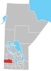
Strathclair is a locality in the province of Manitoba in Western Canada. It is located northwest of Brandon, Manitoba and is on Highway 16. It lies within the Rural Municipality of Yellowhead.

Strathclair
Location of Strathclair in Manitoba
The Post Office opened in 1886 on 35-16-22W and was known as Strathclair Station, became Glenforsa for a time and in 1915 changed to its present name.
Climate
Strathclair is located in southwestern Manitoba and has warm summers and cold winters. The average annual precipitation is 457.1mm (18 inches) with most of it falling in the summer.
| Climate data for Strathclair | |||||||||||||
|---|---|---|---|---|---|---|---|---|---|---|---|---|---|
| Month | Jan | Feb | Mar | Apr | May | Jun | Jul | Aug | Sep | Oct | Nov | Dec | Year |
| Record high °C (°F) | 5 (41) |
11 (52) |
16.5 (61.7) |
33.9 (93.0) |
36.7 (98.1) |
38.3 (100.9) |
35 (95) |
36 (97) |
36.7 (98.1) |
31 (88) |
19.4 (66.9) |
8 (46) |
38.3 (100.9) |
| Average high °C (°F) | −12.9 (8.8) |
−9 (16) |
−2.1 (28.2) |
8.5 (47.3) |
17.3 (63.1) |
21.4 (70.5) |
23.7 (74.7) |
23.3 (73.9) |
16.8 (62.2) |
9.4 (48.9) |
−2.3 (27.9) |
−10.4 (13.3) |
7 (45) |
| Daily mean °C (°F) | −18.5 (−1.3) |
−14.5 (5.9) |
−7.5 (18.5) |
2.6 (36.7) |
10.7 (51.3) |
15.3 (59.5) |
17.4 (63.3) |
16.5 (61.7) |
10.5 (50.9) |
3.6 (38.5) |
−6.9 (19.6) |
−15.4 (4.3) |
1.1 (34.0) |
| Average low °C (°F) | −23.9 (−11.0) |
−19.9 (−3.8) |
−12.8 (9.0) |
−3.4 (25.9) |
4 (39) |
9.1 (48.4) |
11.1 (52.0) |
9.7 (49.5) |
4 (39) |
−2.3 (27.9) |
−11.4 (11.5) |
−20.4 (−4.7) |
−4.7 (23.5) |
| Record low °C (°F) | −44 (−47) |
−44 (−47) |
−37.2 (−35.0) |
−25.6 (−14.1) |
−15 (5) |
−3.3 (26.1) |
−1.1 (30.0) |
−4 (25) |
−10 (14) |
−22 (−8) |
−36 (−33) |
−43 (−45) |
−44 (−47) |
| Average precipitation mm (inches) | 21.6 (0.85) |
16.8 (0.66) |
22.4 (0.88) |
26.4 (1.04) |
43.4 (1.71) |
76.2 (3.00) |
71.6 (2.82) |
62.6 (2.46) |
46.3 (1.82) |
29 (1.1) |
19 (0.7) |
21.9 (0.86) |
457.1 (18.00) |
| Source: Environment Canada[1] | |||||||||||||
gollark: But if you only plan to add new functions, programs can also just do `if not(library.thing and library.otherThing) then error "update weird libraries or something" end`
gollark: Maybe also supply a "is version of X greater than" function.
gollark: Also that.
gollark: Although I think versions are mostly unhelpful and you should have some kind of "is feature X supported" function.
gollark: It is a cool and good™ idea.
References
- Environment Canada Canadian Climate Normals 1971–2000, accessed 19 May 2010
- Geographic Names of Manitoba (pg. 264–265) – the Millennium Bureau of Canada
External links
This article is issued from Wikipedia. The text is licensed under Creative Commons - Attribution - Sharealike. Additional terms may apply for the media files.
