Strasbourg–Danube Corridor
The Strasbourg–Danube Corridor (also known as Seine–Danube Corridor) is the number 10 of the ten priority axes of the Trans-European Transport Network.[1]
| Strasbourg-Danube Corridor | |
|---|---|
 | |
| Route information | |
| Length | 2,137 km (1,328 mi) |
| Major junctions | |
| Start end | |
| End end | |
| Location | |
| Countries | |
| Highway system | |
| Transport in Europe | |
Description
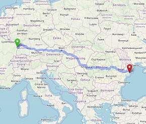
The Strasbourg–Danube Corridor develops its network from the Seine to the Danube on the following three axes and through the following European cities[2] (see route in cyano on the official TEN-T map published on the European Union website visible below in the note).[3]
- Strasbourg – Stuttgart – München – Wels/Linz
- Strasbourg – Mannheim – Frankfurt – Würzburg – Nürnberg – Regensburg – Passau – Wels/Linz
- Wels/Linz – Wien – Budapest – Arad – Brašov – Bucurešti – Constanta - Sulina
gollark: Vote Gibson for MORE GOOD THINGS and FEWER BAD THINGS.
gollark: Very excellent. Can the event language vote gibson?
gollark: Rude.
gollark: <@319753218592866315> Please help us reach 25 votes.
gollark: ++delete all other channels
References
- "Rhine-Danube". ec.europa.eu. Retrieved 13 February 2020.
...passing through the Romanian capital Bucharest to culminate at the Black Sea port of Constanta.
- "PART I: LIST OF PRE-IDENTIFIED PROJECTS ON THE CORE NETWORK IN THE FIELD OF TRANSPORT" (PDF). televideo.rai.it. Retrieved 14 February 2020.
- "TRANS-EUROPEAN TRANSPORT NETWORK" (PDF). ec.europa.eu. Retrieved 14 February 2020.
External links
- Trans-European Transport Network (TEN-T) at European Union official web site
This article is issued from Wikipedia. The text is licensed under Creative Commons - Attribution - Sharealike. Additional terms may apply for the media files.