Stonecoal Creek
Stonecoal Creek is a tributary of the West Fork River, 12.8 miles (20.6 km) long,[3] in north-central West Virginia in the United States. Via the West Fork, Monongahela and Ohio Rivers, it is part of the watershed of the Mississippi River, draining an area of 41 square miles (110 km2)[4] on the unglaciated portion of the Allegheny Plateau. The stream is believed to have been named in the late 1760s by a group of explorers and settlers (including Jesse Hughes), who found coal in nearby hills and mixed with pebbles in the stream.[5]
| Stonecoal Creek | |
|---|---|
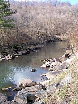
 The Right Fork of Stonecoal Creek, downstream of Stonecoal Lake in 2006 | |
 Location of the mouth of Stonecoal Creek in Weston, West Virginia | |
| Location | |
| Country | United States |
| State | West Virginia |
| Counties | Lewis, Upshur |
| Physical characteristics | |
| Source | |
| • location | northwestern Upshur County |
| • coordinates | 39°00′47″N 80°18′47″W[1] |
| • elevation | 1,453 ft (443 m)[2] |
| Mouth | West Fork River |
• location | Weston, WV |
• coordinates | 39°02′36″N 80°27′43″W[1] |
• elevation | 1,010 ft (310 m)[1] |
| Length | 12.8 mi (20.6 km) |
| Basin size | 41 sq mi (110 km2) |
| Basin features | |
| Tributaries | |
| • left | Right Fork Stonecoal Creek |
Stonecoal Creek rises approximately five miles (8 km) west-northwest of Buckhannon in northwestern Upshur County and flows westwardly into northern Lewis County, where it joins the West Fork River from the east in the city of Weston.[6] Its principal tributary, the 9.7-mile (15.6 km)[3] Right Fork Stonecoal Creek,[7] was dammed in Lewis County to form Stonecoal Lake in 1972 by Allegheny Energy for the purpose of providing water to a power plant in Harrison County. The 550-acre (220 ha) lake is privately owned, but is managed by the West Virginia Division of Natural Resources, as is a Wildlife Management Area surrounding the lake.[8]
According to the West Virginia Department of Environmental Protection, approximately 77% of Stonecoal Creek's watershed is forested, mostly deciduous. Approximately 19% is used for pasture and agriculture, and approximately 2% is urban.[4]
Variant spellings
According to the Geographic Names Information System, Stonecoal Creek has also been known historically as:[1]
- Stone Coal Creek
- Stone Cole Creek
- Stone Cole Run
See also
- List of West Virginia rivers
References
- Geographic Names Information System. "Geographic Names Information System entry for Stonecoal Creek (Feature ID #1547471)". Retrieved 2007-02-19.
- Google Earth elevation for GNIS source coordinates. Retrieved on 2007-02-19.
- United States Environmental Protection Agency. "Watershed Assessment, Tracking & Environmental Results: Assessment Summary for Reporting Year 2008, West Virginia, West Fork Watershed". Archived from the original on 2011-10-14. Retrieved 2011-10-13.
- West Virginia Department of Environmental Protection. "Watershed Atlas Project". pp. West Fork River. Archived from the original on 2005-04-04. Retrieved 2007-02-26.
- Kenny, Hamill (1945). West Virginia Place Names: Their Origin and Meaning, Including the Nomenclature of the Streams and Mountains. Piedmont, West Virginia: The Place Name Press. p. 604.
- DeLorme (1997). West Virginia Atlas & Gazetteer. Yarmouth, Maine: DeLorme. p.36. ISBN 0-89933-246-3.
- Geographic Names Information System. "Geographic Names Information System entry for Right Fork Stonecoal Creek (Feature ID #1545711)". Retrieved 2007-02-19.
- Winters, Kelly (2006). "Stonecoal Lake". In Ken Sullivan (ed.). The West Virginia Encyclopedia. Charleston, W.Va.: West Virginia Humanities Council. p. 684. ISBN 0-9778498-0-5.