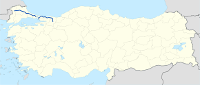
State road D.020 (Turkey)
D.020 is a west to east state road in Turkey running both on Europe and Asia. It starts in Edirne East at the State road D.100 junction near İskender village, and ends in Adapazarı with interruption on the Istanbul Strait. The European part ends in Hasdal at Otoyol 2, and it begins again on the Asian part in Sultanbeyli.[1]
| D.020 | |
|---|---|
 | |
| Route information | |
| Length | 455 km (283 mi) |
| Major junctions | |
| West end | Edirne East |
| East end | Adapazarı |
| Highway system | |
| Turkish State Highway System (Devlet Yolu) List | |
Itinerary
| Province | Location | Distance from (km) | ||
|---|---|---|---|---|
| previous location | Ipsala | Kınalı | ||
| Edirne | Edirne East | 0 | 0 | 455 |
| Hasköy, Edirne | 20 | 20 | 435 | |
| Kırklareli | İnece | 19 | 39 | 416 |
| Kırklareli | 16 | 55 | 400 | |
| Pınarhisar | 28 | 83 | 372 | |
| Vize | 25 | 108 | 347 | |
| Tekirdağ | Saray | 21 | 129 | 326 |
| Istanbul | Hasdal | 118 | 247 | 208 |
| Sultanbeyli | - | 247 | 208 | |
| Kocaeli | Kandıra | 129 | 376 | 79 |
| Sakarya | Kaynarca, Sakarya | 17 | 393 | 62 |
| Adapazarı | 62 | 455 | 0 | |
| 1.000 mi = 1.609 km; 1.000 km = 0.621 mi | ||||
Intersections


gollark: Imagine using C instead of B.
gollark: And just impose a limit or something.
gollark: Thus, it is POSSIBLE to write a compile time raytracer, although the compiler MAY spoil your fun.
gollark: Rust types are Turing complete too!
gollark: This is actually wrong.
References
- Türkiye Haritası (Map) (in Turkish). Karayolları Genel Müdürlüğü. Retrieved 2015-06-17.
This article is issued from Wikipedia. The text is licensed under Creative Commons - Attribution - Sharealike. Additional terms may apply for the media files.