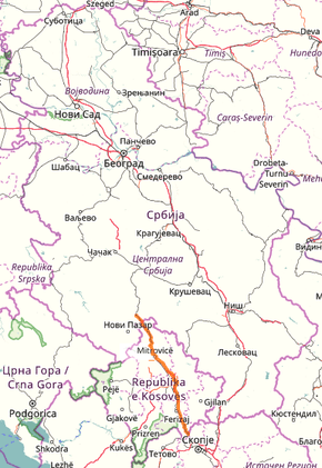
State Road 31 (Serbia)
State Road 31 is an IB-class road in western and southern Serbia, connecting Raška with Serbia/Kosovo-North Macedonia border at Đeneral Janković. It is located in Šumadija and Western Serbia and Kosovo and Metohija regions.[1] The section between Jarinje and Đeneral Janković is under control of Kosovo government and UNMIK.
| ||||
|---|---|---|---|---|
| ||||
 | ||||
| Route information | ||||
| Part of | ||||
| Maintained by JP "Putevi Srbije" | ||||
| Length | 163.694 km (101.715 mi) | |||
| Major junctions | ||||
| From | Raška | |||
| To | Serbia-North Macedonia border at Đeneral Janković Serbia-Kosovo border at Jarinje, Road M-22.3 (excluding Kosovo) | |||
| Location | ||||
| Districts | Raška, Kosovska Mitrovica, Kosovo (Constitution of Serbia) / Mitrovica, Pristina, Ferizaj (UNMIK) | |||
| Highway system | ||||
IB-Class Highways in Serbia
| ||||
Before the new road categorization regulation given in 2013, the route wore the following names: M 22.3 and M 2 (before 2012) / 32 (after 2012).[2][3]
The existing route is a main road with two traffic lanes. By the valid Space Plan of Republic of Serbia the road is not planned for upgrading to motorway, and is expected to be conditioned in its current state.[4]
Sections
| Section number | Length | Distance | Section name |
|---|---|---|---|
| 03101 | 9.049 km (5.623 mi) | 9.049 km (5.623 mi) | Raška - Rudnica |
| 03102 | 1.657 km (1.030 mi) | 10.706 km (6.652 mi) | Rudnica - Kosovo and Metohija border (Jarinje) |
| 03103 | 14.507 km (9.014 mi) | 25.213 km (15.667 mi) | Kosovo and Metohija border (Jarinje) - Dren |
| 03104 | 4.647 km (2.888 mi) | 29.860 km (18.554 mi) | Dren - Leposavić |
| 03105 | 1.754 km (1.090 mi) | 31.614 km (19.644 mi) | Leposavić - Leposavić (Žuta Prla) |
| 03106 | 19.584 km (12.169 mi) | 51.198 km (31.813 mi) | Leposavić (Žuta Prla) - Balaban |
| 03107 | 12.932 km (8.036 mi) | 64.130 km (39.849 mi) | Balaban - Kosovska Mitrovica (Trepča) |
| 03108 | 0.233 km (0.145 mi) | 64.363 km (39.993 mi) | Kosovska Mitrovica (Trepča) - Kosovska Mitrovica (Krpimej) |
| 03109 | 1.132 km (0.703 mi) | 65.495 km (40.697 mi) | Kosovska Mitrovica (Krpimej) - Kosovska Mitrovica (Zubin Potok) |
| 03110 | 8.440 km (5.244 mi) | 73.935 km (45.941 mi) | Kosovska Mitrovica (Zubin Potok) - Vučitrn |
| 03111 | 7.570 km (4.704 mi) | 81.505 km (50.645 mi) | Vučitrn - Novo Selo Mađunsko |
| 03112 | 9.514 km (5.912 mi) | 91.019 km (56.557 mi) | Novo Selo Mađunsko - Miloševo (Lebane) |
| 03113 | 5.801 km (3.605 mi) | 96.820 km (60.161 mi) | Miloševo (Lebane) - Orlović |
| 03114 | 3.262 km (2.027 mi) | 100.082 km (62.188 mi) | Orlović - Priština |
| 03115 | 2.846 km (1.768 mi) | 102.928 km (63.956 mi) | Priština - Čaglavica |
| 03116 | 7.775 km (4.831 mi) | 110.703 km (68.788 mi) | Čaglavica - Laplje Selo |
| 03117 | 5.133 km (3.189 mi) | 115.836 km (71.977 mi) | Laplje Selo - Konjuh |
| 03118 | 3.630 km (2.256 mi) | 119.446 km (74.220 mi) | Konjuh - Lugadžija |
| 03119 | 14.586 km (9.063 mi) | 134.052 km (83.296 mi) | Lugadžija - Uroševac (Gnjilane) |
| 03120 | 5.707 km (3.546 mi) | 139.759 km (86.842 mi) | Uroševac (Gnjilane) - Grlica |
| 03121 | 4.487 km (2.788 mi) | 144.246 km (89.630 mi) | Grlica - Doganović (Štrpce) |
| 03122 | 19.448 km (12.084 mi) | 163.694 km (101.715 mi) | Doganović (Štrpce) - Serbia/Kosovo-North Macedonia border (Đeneral Janković) |
gollark: Have you considered contacting a MENTAL HEALTH PROFESSIONAL™?
gollark: And yet my browser decides to randomly try seeking a *stream* somehow.
gollark: It *is* disabled.
gollark: osmarks internet radio™'s 0 listeners can now know what track is playing *and* how long it is, although this may be inaccurate if their browser does weird stuff.
gollark: Okay, I just managed to implement displaying of... at least what the server is playing on its stream, browsers apparently do some irritating caching stuff.
See also
Notes
- Kosovo is the subject of a territorial dispute between the Republic of Kosovo and the Republic of Serbia. The Republic of Kosovo unilaterally declared independence on 17 February 2008, but Serbia continues to claim it as part of its own sovereign territory. The two governments began to normalise relations in 2013, as part of the 2013 Brussels Agreement. Kosovo is currently recognized as an independent state by 97 out of the 193 United Nations member states. In total, 112 UN member states recognized Kosovo at some point, of which 15 later withdrew their recognition.
References
- "Republic of Serbia - national road network" (PDF). Putevi Srbije (in Serbian).
- "National road categorization regulation - Official Gazette of Republic of Serbia no. 105/2013 and 119/2013" (PDF). Serbian Spatial Planners Association (in Serbian).
- "Link between actual and previous section and road markings" (PDF). Putevi Srbije (in Serbian).
- Space plan of Republic of Serbia from 2010 to 2021
External links
This article is issued from Wikipedia. The text is licensed under Creative Commons - Attribution - Sharealike. Additional terms may apply for the media files.
