State Road 109 (Serbia)
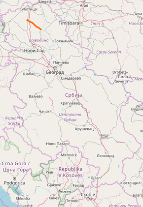
State Road 109, is an IIA-class road in northern Serbia, connecting Bačka Topola with Bečej. It is located in Vojvodina.[1]
| ||||
|---|---|---|---|---|
| ||||
 | ||||
| Route information | ||||
| Maintained by JP "Putevi Srbije" | ||||
| Length | 37.995 km (23.609 mi) | |||
| Major junctions | ||||
| From | Bačka Topola | |||
| To | Bečej | |||
| Location | ||||
| Districts | North Bačka, Central Banat | |||
| Highway system | ||||
IIA-Class Highways in Serbia
| ||||

Before the new road categorization regulation given in 2013, the route wore the following names: P 108 (before 2012) / 120 (after 2012).[2][3]
The existing route is a regional road with two traffic lanes. By the valid Space Plan of Republic of Serbia the road is not planned for upgrading to main road, and is expected to be conditioned in its current state.[4]
Sections
| Section number | Length | Distance | Section name |
|---|---|---|---|
| 10901 | 37.995 km (23.609 mi) | 37.995 km (23.609 mi) | Bačka Topola (Bečej) – Bečej (Bačka Topola) |
gollark: ...
gollark: Which they won't, because it would not provide any useful service to them.
gollark: But that's not helpful if nobody uses it.
gollark: I mean, if by "hub" you mean "online list of participating servers and modpacks", that would work fine.
gollark: Though it makes the hub pointless, yes.
See also
References
- "Republic of Serbia – national road network" (PDF). Putevi Srbije (in Serbian).
- "National road categorization regulation – Official Gazette of Republic of Serbia no. 105/2013 and 119/2013" (PDF). Serbian Spatial Planners Association (in Serbian).
- "Link between actual and previous section and road markings" (PDF). Putevi Srbije (in Serbian).
- Space plan of Republic of Serbia from 2010 to 2021
External links
This article is issued from Wikipedia. The text is licensed under Creative Commons - Attribution - Sharealike. Additional terms may apply for the media files.