Stříbrné Hory
Stříbrné Hory, until 1947 Český Šicndorf (German: Böhmisch Schützendorf) is a village and municipality (obec) in Havlíčkův Brod District in the Vysočina Region of the Czech Republic.
Stříbrné Hory | |
|---|---|
Municipality | |
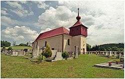 Church of Saint Catherine | |
_vlajka.jpg) Flag _znak.jpg) Coat of arms | |
 Stříbrné Hory | |
| Coordinates: 49°36′17″N 15°41′27″E | |
| Country | |
| Region | Vysočina |
| District | Havlíčkův Brod |
| Area | |
| • Total | 3.73 km2 (1.44 sq mi) |
| Elevation | 473 m (1,552 ft) |
| Population (2020)[1] | |
| • Total | 251 |
| • Density | 67/km2 (170/sq mi) |
| Postal code | 582 22 |
| Website | http://www.stribrnehory.cz/ |
The municipality covers an area of 3.73 square kilometres (1.44 sq mi), and has a population of around 251.
Stříbrné Hory lies approximately 9 kilometres (6 mi) east of Havlíčkův Brod, 25 km (16 mi) north of Jihlava, and 106 km (66 mi) south-east of Prague.
References
- "Population of municipalities of the Czech Republic". Czech Statistical Office. 1 January 2020.
This article is issued from Wikipedia. The text is licensed under Creative Commons - Attribution - Sharealike. Additional terms may apply for the media files.