South Turramurra
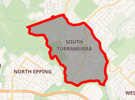
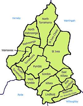
South Turramurra is a suburb on the Upper North Shore of Sydney in the state of New South Wales, Australia 18 kilometres (11 mi) north-west of the Sydney central business district, in the local government area of Ku-ring-gai Council. Turramurra and North Turramurra are separate suburbs.[2]
| South Turramurra Sydney, New South Wales | |||||||||||||||
|---|---|---|---|---|---|---|---|---|---|---|---|---|---|---|---|
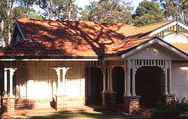
 Contemporary Federation home, Kissing Point Road | |||||||||||||||

| |||||||||||||||
| Population | 3,084 (2016 census)[1] | ||||||||||||||
| • Density | 1,028/km2 (2,660/sq mi) | ||||||||||||||
| Established | 1885 | ||||||||||||||
| Postcode(s) | 2074 | ||||||||||||||
| Area | 3.0 km2 (1.2 sq mi) | ||||||||||||||
| Location | 18 km (11 mi) north-west of Sydney CBD | ||||||||||||||
| LGA(s) | Ku-ring-gai Council | ||||||||||||||
| State electorate(s) | Ku-ring-gai | ||||||||||||||
| Federal Division(s) | Bradfield | ||||||||||||||
| |||||||||||||||

South Turramurra is a leafy suburb, surrounded by the upper section of the Lane Cove National Park. There are many walking trails, including the Great North Walk and walking trails with access to neighbouring suburbs such as North Epping, Marsfield and West Pymble.
History
Turramurra is an Aboriginal word which is thought to mean either big hill, high place,[3] or small watercourse.[4] Early settlers referred to the area as Eastern Road until the name Turramurra was adopted when the railway station was built in 1897.
During the early 1990s a community organisation (Coalition Against Lane Cove Valley Freeways) was formed to oppose plans for the construction of the B2/B3 extension, designed to connect the M2 motorway in North Epping with the Pacific Highway.[5]
South Turramurra became a separate suburb from Turramurra on 5 August 1994.[6]
Demographics
At the 2016 census, the suburb of South Turramurra recorded a population of 3,084 people. Census data shows that:[1]
- South Turramurra's Age distribution reflects the popularity of the suburb with families and retirees. The median age was 42 years, compared to the national median of 38 years. Children aged under 15 years made up 23.7% of the population (national average is 18.7%) and people aged 65 years and over made up 18.1% of the population (national average is 15.8%).
- Ethnic diversity : 67.8% of people were born in Australia, compared to the national average of 65.5%; the next most common country of birth was England at 6.0. 77.6% of people only spoke English at home. Other languages spoken at home included Mandarin at 3.8%.
- Religion : The most common responses for religion were No Religion 32.6%, Anglican 21.0% and Catholic 17.8%.
- Finances: South Turramurra is a wealthy suburb. The median household weekly income was $2,564, compared to the national median of $1,438. This difference is also reflected in real estate, with the median mortgage payment being $3,000 per month, compared to the national median of $1,755.
- Housing: The great majority (98.2%) of occupied private dwellings were separate houses. The average household size was 3.1 people.
Transport
The nearest train station is Turramurra railway station. Buses to South Turramurra operate from Turramurra train station. The Transdev NSW bus route 571 runs between Turramurra and South Turramurra along Kissing Point Road, and route 572 runs the same route extended to Macquarie University.
The Comenarra Parkway, a minor arterial road consisting of only one lane in each direction, creates a boundary with Turramurra, to the north and West Pymble to the south.
Commercial area
South Turramurra Shopping Village is located on the corner of Auluba Road and Kissing Point Road.
Schools
- Turramurra High School Located on Maxwell Street
- Turramurra Public School is located on the south side of Turramurra but is technically in Turramurra, not South Turramurra
Parks
South Turramurra is surrounded on the other three sides by the Lane Cove National Park.
- Field of Dreams, Kissing Point Road near Vernon Street
- Sir David Martin Oval (Auluba Oval), Auluba Road (Home of Kissing Point Sports Club)
- Netball Courts, Canoon Road
Sport and recreation
The area is home to the Kissing Point Sports Club. The club consists of:
Community
The strong community support for the anti-freeway campaigners resulted in the protection of the bushland at the foot of the suburb of South Turramurra as part of the Lane Cove River National Park. Many different and diverse action groups were formed (and still remain) in order to effectively lobby government. The environmental community group STEP Inc, which was formed in South Turramurra in 1978 has grown to be a powerful force for the environment in northern Sydney.
1st Turramurra Scout Group is one of the oldest and strongest Scout Groups on the northside, with active programs for boys and girls aged from 8–11 Cub Scouts, 11–15 Scouts through to young men and women 15–17 Venturer Scouts and 18–25 Rovers.[7]
Turramurra and Kissing Point Rover Scout Crews, both based on the south side of Turramurra, are active groups of young people aged 18~25, who are into a wide range of outdoor, social and community service activities.
There are also a number of Churches and various religious temples in South Turramurra, some having youth groups for children aged 5 - 18 years old.
Climate
| Climate data for Macquarie Park (Willandra Village) | |||||||||||||
|---|---|---|---|---|---|---|---|---|---|---|---|---|---|
| Month | Jan | Feb | Mar | Apr | May | Jun | Jul | Aug | Sep | Oct | Nov | Dec | Year |
| Record high °C (°F) | 44.5 (112.1) |
41.4 (106.5) |
40.7 (105.3) |
33.5 (92.3) |
28.5 (83.3) |
24.8 (76.6) |
26.0 (78.8) |
30.1 (86.2) |
34.4 (93.9) |
39.1 (102.4) |
42.0 (107.6) |
43.2 (109.8) |
44.5 (112.1) |
| Average high °C (°F) | 27.7 (81.9) |
27.4 (81.3) |
25.9 (78.6) |
23.4 (74.1) |
20.3 (68.5) |
17.4 (63.3) |
17.1 (62.8) |
18.5 (65.3) |
21.1 (70.0) |
23.3 (73.9) |
24.8 (76.6) |
27.2 (81.0) |
22.8 (73.0) |
| Average low °C (°F) | 16.9 (62.4) |
16.9 (62.4) |
15.2 (59.4) |
12.0 (53.6) |
9.2 (48.6) |
6.5 (43.7) |
4.9 (40.8) |
5.7 (42.3) |
7.8 (46.0) |
10.8 (51.4) |
13.0 (55.4) |
15.6 (60.1) |
11.2 (52.2) |
| Record low °C (°F) | 8.5 (47.3) |
8.9 (48.0) |
6.1 (43.0) |
2.5 (36.5) |
0.3 (32.5) |
−1.7 (28.9) |
−3.5 (25.7) |
−1.1 (30.0) |
0.1 (32.2) |
0.9 (33.6) |
1.2 (34.2) |
6.5 (43.7) |
−3.5 (25.7) |
| Average precipitation mm (inches) | 114.1 (4.49) |
144.2 (5.68) |
131.4 (5.17) |
107.3 (4.22) |
88.0 (3.46) |
113.3 (4.46) |
57.4 (2.26) |
56.1 (2.21) |
61.1 (2.41) |
86.1 (3.39) |
93.1 (3.67) |
84.3 (3.32) |
1,139.1 (44.85) |
| Average precipitation days | 12.5 | 12.8 | 13.2 | 10.3 | 10.5 | 10.8 | 8.6 | 8.0 | 8.1 | 10.8 | 12.9 | 11.2 | 129.7 |
| Source: Bureau of Meteorology[8] | |||||||||||||
References
- Australian Bureau of Statistics (31 October 2012). "South Turramurra (State Suburb)". 2011 Census QuickStats. Retrieved 3 September 2017.

- Gregorys Sydney Street Directory, Gregorys Publishing Company, 2007
- "Turramurra". Kur-ing-gai Historical Society. Retrieved 9 September 2013.
- McCarthy; 1963, cited in "Turramurra". Geographical Names Register (GNR) of NSW. Geographical Names Board of New South Wales. Retrieved 22 January 2015.

- The Book of Sydney Suburbs, Frances Pollon, Angus and Robertsons, 1990
- "South Turramurra (Suburb)". Geographical Names Register (GNR) of NSW. Geographical Names Board of New South Wales. Retrieved 5 July 2014.

- "1st Turramurra Scout Group". Scouts Australia NSW. Retrieved 4 August 2013.
- "Macquarie Park (Willandra Village)". Climate statistics for Australian locations. Bureau of Meteorology. Retrieved 20 October 2011.
External links
- Joan Rowland (2011). "South Turramurra". Dictionary of Sydney. Retrieved 29 September 2015. [CC-By-SA]