South Carolina Highway 768
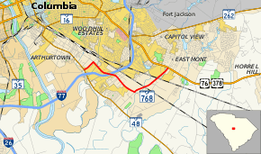
South Carolina Highway 768 (SC 768) is a primary state highway in the U.S. state of South Carolina. It serves to connect businesses along Shop Road to nearby state highways.
| ||||
|---|---|---|---|---|
 | ||||
| Route information | ||||
| Maintained by SCDOT | ||||
| Length | 4.88 mi[1] (7.85 km) | |||
| Existed | 1982–present | |||
| Major junctions | ||||
| West end | ||||
| East end | ||||
| Location | ||||
| Counties | Richland | |||
| Highway system | ||||
| ||||
Route description
SC 768 is an urban highway that zig-zags from SC 48 to U.S. Route 76 (US 76) and 378 for 4.88 miles (7.85 km). The main stretch is Shop Road, where it is a four-lane divided highway and has an interchange with Interstate 77 (I-77); while Beltline Boulevard and Pineview Road are a two-lane with a median.[2]
History
The first SC 768 appeared from 1942-1948 as a spur off US 76, from Marion 4 miles (6.4 km) to Pitch Pot Swamp. It was downgraded to secondary status.
The current SC 768 was established between 1980–82, as a new primary routing; which has changed little since.[3]
Major intersections
The entire route is in Richland County.
| Location | mi[1] | km | Destinations | Notes | |
|---|---|---|---|---|---|
| Columbia | 0.00 | 0.00 | |||
| 1.31– 1.82 | 2.11– 2.93 | I-77 exit 6 | |||
| | 4.88 | 7.85 | |||
| 1.000 mi = 1.609 km; 1.000 km = 0.621 mi | |||||
References
- "Statewide Highways (shapefile)" (zip). South Carolina Department of Transportation. September 29, 2017. Retrieved December 8, 2017.
- Google (November 23, 2012). "South Carolina Highway 768" (Map). Google Maps. Google. Retrieved November 23, 2012.
- "Mapmikey's South Carolina Highways Page (SC 760-779)". Retrieved November 23, 2012.
External links

