South Carolina Highway 60
South Carolina Highway 60 (SC 60) is a primary state highway in the U.S. state of South Carolina. It serves the town of Irmo, connecting nearby Lake Murray and Harbison State Forest.
| ||||
|---|---|---|---|---|
| Lake Murray Boulevard | ||||
 | ||||
| Route information | ||||
| Maintained by SCDOT | ||||
| Length | 5.16 mi[1] (8.30 km) | |||
| Existed | 1929–present | |||
| Major junctions | ||||
| West end | ||||
| East end | ||||
| Location | ||||
| Counties | Lexington, Richland | |||
| Highway system | ||||
| ||||

Route description
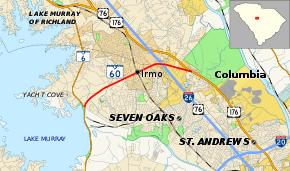
SC 60 is a mostly four-lane with median suburban highway that travels 5.16 miles (8.30 km) from SC 6 to U.S. Route 176 (US 176), with an interchange with Interstate 26 (I-26)/US 76.[2]
History
SC 60 was established in 1929 as a new primary routing. The route has remained unchanged since inception, though its eastern endpoint was originally US 76/SC 2; the highway was widened to mostly four lanes with median by 2000.
Junction list
| County | Location | mi[1] | km | Destinations | Notes |
|---|---|---|---|---|---|
| Lexington | | 0.00 | 0.00 | ||
| Richland | Irmo | 3.75 | 6.04 | Exit 102A–B (I-26) | |
| | 5.16 | 8.30 | |||
| 1.000 mi = 1.609 km; 1.000 km = 0.621 mi | |||||
gollark: Phones are, in fact, computers.
gollark: > seeing adverts on your computer
gollark: ↑_↑
gollark: Based on the picture, that is one of those times.
gollark: In my time as unofficial and unwilling tech support person, I found that often the real problem with the computer setup was the user.
References
- South Carolina Department of Transportation: Statewide Highways 2012. Specifics: . Files: .
- Google (September 6, 2013). "South Carolina Highway 60" (Map). Google Maps. Google. Retrieved September 6, 2013.
External links

- Mapmikey's South Carolina Highways Page: SC 60-69
This article is issued from Wikipedia. The text is licensed under Creative Commons - Attribution - Sharealike. Additional terms may apply for the media files.