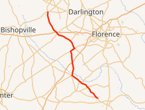
South Carolina Highway 403
South Carolina Highway 403 (SC 403) is a primary state highway in the U.S. state of South Carolina. It serves the town of Timmonsville and the surrounding rural area with the cities of Lake City and Hartsville.
| ||||
|---|---|---|---|---|

| ||||
| Route information | ||||
| Maintained by SCDOT | ||||
| Length | 36.1 mi[1] (58.1 km) | |||
| Existed | 1940–present | |||
| Major junctions | ||||
| South end | ||||
| ||||
| North end | ||||
| Location | ||||
| Counties | Florence, Sumter, Darlington | |||
| Highway system | ||||
| ||||
Route description
SC 403 is a two-lane rural highway that traverses for 36.1 miles (58.1 km) beginning north of Lake City, along SC 341. Going through a northeasterly direction to Hobbs Crossroads, it then goes north to Sardis. Connecting with Interstate 95 (I-95) north of Sardis, it continues north connecting with U.S. Route 76 (US 76) near and then through Timmonsville. At Windhams Crossroads, it connects with US 401, where it provides access to I-20. At Lees Crossroads, it overlaps for .2 miles (0.32 km) with US 15 before it ends, along the road towards Hartsville. The vast majority of the landscape along the route is farmland, with the exception in and around Timmonsville.[2][3][4]
History
SC 403 was established in 1933 as a renumbering of US 301 from US 76 in Timmonsville to US 15 at Lees Crossroads. The entire route was paved in 1939. Around 1942, SC 403 was extended south SC 407 in Sparrows Crossroads. In 1948, SC 403 was retracted back to its original routing, leaving behind Hill Road (S-21-38). Between 1968-1970, SC 403 was extended south to its current southern terminus with SC 341, replacing part of SC 53 and nearly all of SC 309. Between 2005-2012, US 15 was realigned its Lees Crossroads intersection, removing an intersection corner bypass, giving an odd overlap with SC 403 for 0.2 miles (0.32 km) to where the corner bypass originally reconnected.
South Carolina Highway 309
| |
|---|---|
| Location | Hobbs Crossroads-Camp Branch |
| Length | 11.9 mi[5] (19.2 km) |
| Existed | 1940–1970 |
South Carolina Highway 309 (SC 309) was established in 1940 as a new primary routing, from SC 341 in Hobbs Crossroads, southeast to US 301. By 1942, it was extended southeast to reconnect with SC 341. Between 1968-1970, SC 309 was renumbered as an extension of SC 403 with only its westernmost piece downgraded to secondary road (Lynches River Road S-42-14).
Junction list
| County | Location | mi[1] | km | Destinations | Notes |
|---|---|---|---|---|---|
| Florence | Camp Branch | 0.0 | 0.0 | ||
| Byrds Crossroads | 5.0 | 8.0 | To Lynches River County Park | ||
| Kelley Crossroads | 7.8 | 12.6 | |||
| Sumter | Hobbs Crossroads | 11.3 | 18.2 | Northern terminus of SC 53 | |
| Florence | | 15.4 | 24.8 | I-95 exit 150 | |
| | 19.1 | 30.7 | West end of US 76 overlap | ||
| Timmonsville | 20.6 | 33.2 | East end of US 76 overlap | ||
| Darlington | Windhams Crossroads | 28.1 | 45.2 | ||
| Lees Crossroads | 35.9 | 57.8 | South end of US 15 overlap | ||
| 36.1 | 58.1 | North end of US 15 overlap | |||
1.000 mi = 1.609 km; 1.000 km = 0.621 mi
| |||||
References
- Google (September 4, 2013). "South Carolina Highway 403" (Map). Google Maps. Google. Retrieved September 4, 2013.
- Florence County (PDF) (Map). South Carolina Department of Transportation. July 2005. Retrieved September 4, 2013.
- Sumter County (PDF) (Map). South Carolina Department of Transportation. August 2005. Retrieved September 4, 2013.
- Darlington County (PDF) (Map). South Carolina Department of Transportation. July 2005. Retrieved September 4, 2013.
- Google (September 4, 2013). "South Carolina Highway 309" (Map). Google Maps. Google. Retrieved September 4, 2013.
External links

- Mapmikey's South Carolina Highways Page: SC 300-309
- Mapmikey's South Carolina Highways Page: SC 400-409
