South Carolina Highway 392
South Carolina Highway 392 (SC 392) is a 3.6-mile-long (5.8 km) state highway in the U.S. state of South Carolina. The highway connects rural areas of Aiken and Saluda counties with Ridge Spring.
| ||||
|---|---|---|---|---|
| ||||
| Route information | ||||
| Maintained by SCDOT | ||||
| Length | 3.62 mi[1] (5.83 km) | |||
| Major junctions | ||||
| South end | ||||
| North end | ||||
| Location | ||||
| Counties | Aiken, Saluda | |||
| Highway system | ||||
| ||||

Route description
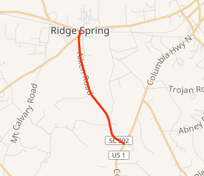
SC 392 begins at an intersection with U.S. Route 1 (US 1; Columbia Highway) south-southeast of Ridge Spring, Aiken County. This intersection is southwest of Aiken Wayside Park. It travels to the northwest and curves to the north-northwest. The highway enters Saluda County. It crosses Flat Rock Creek and passes by Flat Rock Cemetery just before entering the city limits of Ridge Spring. At Main Street, it meets its northern terminus, an intersection with SC 23/SC 39.[2]
Major intersections
| County | Location | mi[1] | km | Destinations | Notes |
|---|---|---|---|---|---|
| Aiken | | 0.00 | 0.00 | ||
| Saluda | Ridge Spring | 3.62 | 5.83 | ||
| 1.000 mi = 1.609 km; 1.000 km = 0.621 mi | |||||
gollark: It would be useful if it was proved or disproved, and one of the things it would be useful for is Project PURPOSELESS CHAIRMANSHIPS, you see.
gollark: Yes, I know, I'm saying it's necessary for the successful completion of Project PURPOSELESS CHAIRMANSHIPS.
gollark: Yes, we get those frequently.
gollark: Please do, it would really help with Project PURPOSELESS CHAIRMANSHIPS?
gollark: Go prove the Riemann hypothesis or something.
See also


References
- "Statewide Highways (shapefile)" (zip). South Carolina Department of Transportation. September 29, 2017. Retrieved December 8, 2017.
- Google (May 14, 2016). "South Carolina Highway 392" (Map). Google Maps. Google. Retrieved May 14, 2016.
External links

- SC 392 South Carolina Hwy Index
This article is issued from Wikipedia. The text is licensed under Creative Commons - Attribution - Sharealike. Additional terms may apply for the media files.